


Services on Demand
Journal

Article
 English (pdf)
 Article in xml format
 Article references
 Send this article by e-mail
Indicators
Related links
-
 Cited by Google
 -
 Similars in Google
Share

 Permalink
Journal of the Southern African Institute of Mining and Metallurgy
On-line version ISSN 2411-9717Print version ISSN 2225-6253
J. S. Afr. Inst. Min. Metall. vol.125 n.1 Johannesburg Jan. 2025
https://doi.org/10.17159/2411-9717/3432/2025
PROFESSIONAL TECHNICAL AND SCIENTIFIC PAPERS
Advanced seismic acquisition techniques in South African mines: Insights from the FUTURE project
M.K. RapetsoaI; M.S.D. ManziI; M. SihoyiyaI; A. MalehmirII; I. JamesI; LV. SoccoIII; J. LepineIV; C. ColomberoIII; O. ValeshinIV; R.J. DurrheimI
ISchool of Geosciences, University of the Witwatersrand, Johannesburg, South Africa. ORCiD M.K Rapetsoa: http://orcid.org/000C-0003-3275-8994; M.S.D Manzi: http://orcid.org/0000-0002-1654-5211; M. Sihoyiya: http://orcid.org/0000-0003-1956-5223; I. James: http://orcid.org/0000-0002-1655-3529; R.J. Durrheim: http://orcid.org/0000-0003-3832-0600
IIUppsala University, Uppsala, Sweden. ORCiD A. Malehmir: http://orcid.org/0000-0003-1241-2988
IIIPolitecnico do Torino,Turin, Italy. ORCiD L.V. Socco: http://orcid.org/0000-0001-8830-9050; C. Colombero: http://orcid.org/0000-0001-9818-7464
IVSercel, Nantes, France
ABSTRACT
The FUTURE project aims to enhance seismic surveying in South African mining by integrating advanced acquisition technologies. In this paper, we detail surface and underground seismic surveys at the South Deep gold mine as part of the project. Surface seismic acquisition used co-located broadband micro-electromechanical sensors, one and three component recorders connected to geophones, distributed acoustic sensing using a straight fibre optic cable, along with a 6 ton broadband seismic vibrator operating with 4-180 Hz linear sweeps. In addition, underground surveys employed a combination of straight, and helically wound fibre optic cables, cabled-based and nodal sensors, along with a 500 kg drophammer mounted on a skid steer bobcat. The surface and underground seismic arrays were time synchronised using a GPS-time transmitter to allow for accurate seismic data recording in a GPS-denied environment. Results show the efficacy of these techniques in acquiring high-resolution seismic data, revealing detailed subsurface geological structures and mineralisation down to 3500 m below ground surface. Surface data revealed clear seismic reflections corresponding to the Black Reef and Ventersdorp Contact Reef. An underground P-wave velocity model exhibits low velocity anomalies that are associated with fracturing, while a P-wave reflection stack section shows significant reflections and a degree of faulting below the tunnel floor that was not observed on the surface reflection seismic data. We highlight the potential of these technologies to enhance safety, efficiency, and sustainability in mining. This study sets a benchmark for future reflection seismic surveys, paving the way for safer, more efficient, deep mineral exploration and extraction practices.
Keywords: seismics, mining, mine design, exploration, DAS
Introduction
The South African mining industry is a critical component of the national economy, contributing significantly to employment and export revenues. However, the industry faces numerous challenges, including the need for improved safety, efficient resource extraction, and accurate subsurface imaging (Manzi et al., 2012a, 2012b; Pretorius et al., 2000; Rapetsoa et al., 2024). Geophysical methods play a crucial role in mineral exploration, mine planning and safety. In particular, the seismic methods have been pivotal in deep gold exploration and mine development in the Witwatersrand goldfields by offering high-resolution imaging of gold-bearing horizons (pebble conglomerates known as reefs) and complex geological structures (faults, dykes, and sills) that have a direct impact on ore extraction (Malehmir et al., 2014; Nkosi et al., 2018; Mutshafa et al., 2023). However, seismic surveys in a structurally complex, metamorphosed, and deformed mining environment, such as the Witwatersrand Basin, yields specific complications, such as low signal-to-noise ratio and strongly scattered seismic energy (Salisbury et al., 2003). In terms of resolution, mine tunnels provide the opportunity to bring seismic instruments closer to the target, thus providing higher resolution and better depth of penetration. Like surface-based surveys, in-mine surveys pose several challenges that need to be addressed such as: (1) lack of GPS signal inside the mines, (2) high level of noise from mine operations and infrastructure, and (3) limited space inside the mine for proper survey designs.
Recent technological advancements in seismic acquisition are transforming the field of geophysics, particularly for mining applications (Malehmir et al., 2012). Distributed acoustic sensing (DAS) technology, which leverages straight and helically wound fibre optic cables to measure seismic wave propagation, offers improved data resolution due to their broadband nature, deployment efficiency, and cost-effectiveness (Douglass et al., 2023; Rafi et al., 2024). Similarly, P-wave broadband sources and nodal sensors (single and three-component) provide flexibility and enhanced data quality for both surface and underground seismic surveys (Stotter and Angerer, 2011; Tellier et al., 2021). These innovations present an opportunity to address the shortcomings of traditional methods, enabling more accurate imaging and safer mining operations.
The FUTURE (Fibre-Optic Sensing and UAV-Platform Techniques for Innovative Mineral Exploration) project represents a pioneering effort to address mining challenges through the integration of advanced seismic acquisition technologies. The project builds upon previous studies, such as those conducted at Maseve mine (Rapetsoa et al., 2022). In this study, we aim to enhance the imaging capabilities and operational safety mines by leveraging state-of-the-art equipment, such as nodal systems (1C and 3C), and distributed acoustic sensing (DAS) technologies.
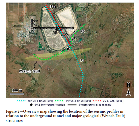
In this paper, we provide a detailed account of the surface and underground seismic surveys conducted at the South Deep gold mine as part of the FUTURE project. The South Deep mine, one of the world's largest gold deposits, presents a challenging environment due to its extreme depth of ~3700 m, significant environmental noise from ongoing mining operations, and geological complexity introduced by features such as dykes and faults (e.g., the Wrench Fault), making it an ideal site for testing and advancing innovative seismic technologies. By deploying both traditional and cutting-edge methods, the project seeks to establish a comprehensive understanding of subsurface structures and improve the detection of ore bodies and potential hazards.
The technical objectives of this study are to document the seismic acquisition parameters and methodologies employed during surface and underground surveys, compare the effectiveness of traditional seismic methods with advanced techniques like distributed acoustic sensing (DAS), wireless recorders connected to geophones, and micro-electromechanical systems (MEMS) accelerometers in challenging mine environments, establish a benchmark for future seismic surveys in the mining industry, and contribute to the development of safer and more efficient seismic survey techniques that will ultimately improve operational safety and resource extraction in the mining sector. The paper also addresses some challenges that are related to in-mine seismic surveys in active deep mines and provide guidelines that may be useful when designing similar surveys in other deep mines in the world.
The geological objectives of the surveys are to image the gold deposits and delineate geological structures, such as faults and dykes ahead of the mine face that may: (1) affect mine planning and development, (2) act as conduits for water and flammable gas ingress into mining levels, and (3) be re-activated and result in seismicity.
Acquisition
Surface Acquisition
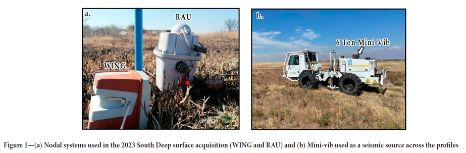
The surface seismic acquisition involved deploying two distinct nodal systems: the WING node or digital field unit (DFU) and the remote acquisition unit (RAU), as illustrated in Figure 1(a). These systems were utilised to compare their performance and data quality. A total of 485 broadband MEMS sensors (WING) and 485 one-component RAUs (5 Hz) were co-located along the seismic profiles to ensure consistency in data comparison. Additionally, 91 three-component RAUs were deployed along Profile 1 (P1a) with a spacing of 20 m to provide more detailed imaging of specific targets. Both the Wings and RAU were spaced at 10 m. A 6 ton mini-vib (Figure 1b) was used as the seismic source, providing a controlled and repeatable signal with a sweep length of 48 s sweep frequencies ranging from 4 to 180 Hz. The Sercel Lite system was employed for data acquisition, ensuring high fidelity and reliability in recording the seismic signals. Differential Global Positioning System (DGPS) was used for precise geodetic surveying, ensuring accurate positioning of the sensors and source points.
Profile 1 (P1) targeted the Wrench Fault (WF) trending southwest-northeast, aiming to capture detailed seismic reflections and structural information related to the WF system. Profile 2 (P2), positioned above active mine tunnels, aimed to complement the underground seismic surveys by improving the imaging of structures above the mine tunnels.
Distributed Acoustic Sensing (DAS)
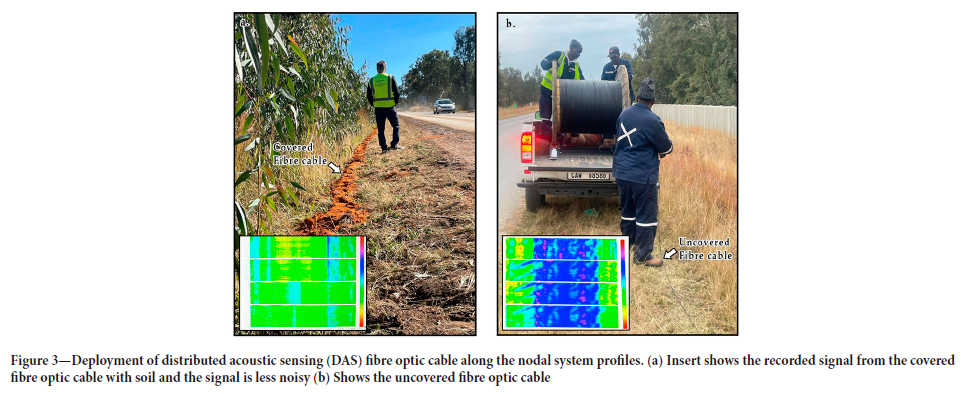
To enhance data quality and capture additional seismic information, distributed acoustic sensing (DAS) technology was integrated alongside the nodal systems. The fibre optic cable used in DAS was strategically deployed alongside the nodal systems for comparison purposes. The fibre optic cable had a total length of 1820 m, with a gauge length set at 10 m and a spatial sampling interval of 5 m, resulting in a high-density channel configuration along the fibre length. To improve the coupling and signal quality, the fibre optic cable was covered with sand (Figure 3a), which significantly reduced noise levels compared to the uncovered fibre cable (Figure 3b). The DAS interrogator was fixed at a single location for three days, capturing both passive and active seismic data.
Tunnel Acquisition
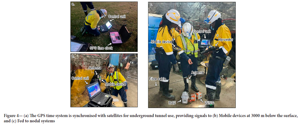
The underground seismic survey at South Deep gold mine involved a combination of cabled systems, nodal sensors, and fibre optic cables. These experiments aimed to assess the feasibility of using seismic surveys in GPS-denied environments and to compare various acquisition technologies. Before deployment underground, the GPS time system developed under the Smart Exploration Project (Malehmir et al., 2019) was synchronised with satellites on the surface (Figure 4a). Upon reaching 3000 m below the surface, the GPS system was connected to a mobile device to ensure functionality (Figure 4b). The system was then integrated with the nodal sensors and tested using the harvester (Figure 4c).
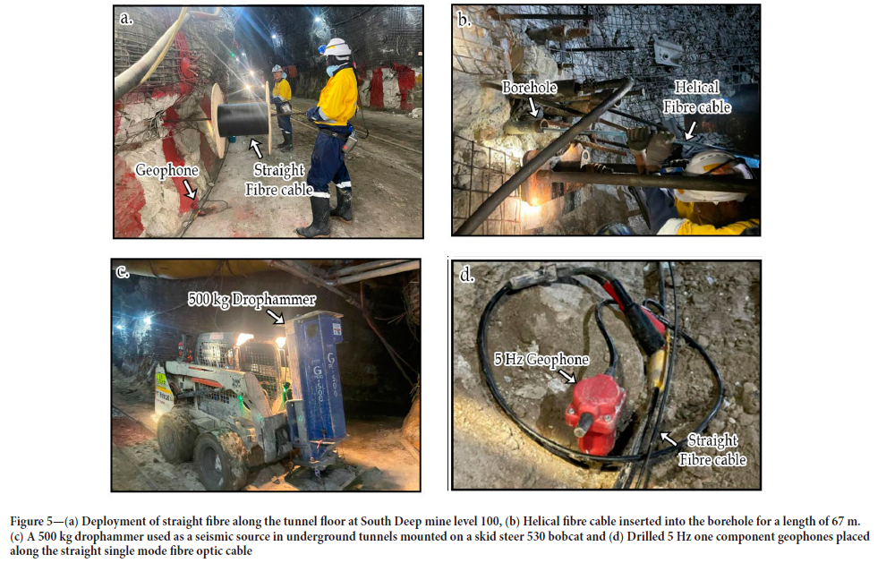
Two types of fibre optic cables were used: a straight single-mode fibre optic cable (Figure 5a:~727 m along the tunnel floor) and a multimode helical wound fibre optic cable (Figure 5b: 67 m inserted into a near-horizontal borehole). The cables were spliced together, extending the total fibre length to approximately 763 m. The straight fibre was covered with gravel to enhance coupling with the tunnel floor. A 500 kg drophammer mounted on a skid steer bobcat was used as the seismic source (Figure 5c). Shot spacing was set at 10 m, with each location receiving a minimum of four shots. One-component 5 Hz spiked geophones were drilled into the ground every 5 m for optimal coupling (Figure 5d). These geophones were connected in a series using the Geode system powered by 12 V lithium batteries.
The DAS interrogator was set up near the refuge bay at level 100, working in conjunction with the GPS-time system for precise time tagging. The GPS-time (micro-second accuracy) system can transmit a simulated real or false GPS-time signal without cabling from the surface. Prior to data acquisition, a tap test was conducted along the fibre optic cable to map its response and correlate it with geophone locations. The DAS system operated simultaneously with the cabled seismic system, capturing both passive and active seismic signals. A GPS-time tagging system was used to synchronise the tunnel DAS and surface nodal array to capture the seismic wavefield between the tunnels and the surface. Integrating the GPS-time system with the fibre optic cable through the DAS interrogators GPS antenna reduces the attenuation of the GPS-time signal along the length of the fibre cable. Despite the challenges encountered while conducting a survey in an active and operating deep mine, we managed to acquire more than 240 shot records for both surface and underground surveys, with the GPS-time transmitter also used for the continuous recording of passive seismic data (e.g., ambient noise). The time-synchronised surface and tunnel array enable the scanning of the rock mass between the surface and the tunnels like a magnetic resonance imaging (MRI) scanning device.
In selecting the equipment for the FUTURE project, we focused on systems that met the specific needs of the study, such as high-resolution imaging and depth of penetration, ensuring optimal data acquisition for subsurface imaging in the challenging South Deep mine environment.
These needs were addressed later in the study, as we successfully achieved the required resolution and depth of penetration. While a comprehensive comparison with other available systems was not conducted, the chosen equipment, including the WING, RAU, and DAS, were selected based on their ability to meet key parameters such as high resolution, flexibility, and reliability. These systems were ideal for complex geological conditions at these mining depths and the operational demands of the mine. For example, to increase the resolution and depth of penetration compared to the previous studies, a combination of a broadband source with broadband nodal receivers was used. DAS systems are also broadband continuous array of sensors (Willis, 2022). The benefits of generating and recording a broadband signal include the reduction of seismic wavelet side lobes by low frequencies and sharpening of the seismic wavelet by higher frequencies (Manzi et al., 2018). The previous surveys in the same area were acquired using a conventional (bandwidth limited) seismic source (10-96 Hz sweep frequency) and 10 Hz cabled geophones (Manzi et al., 2012a, b; Manzi et al., 2013). MEMS sensors (accelerometers) were also chosen because they are insensitive to electromagnetic noise, which is dominant in an operating mine like South Deep mine. Furthermore, sources and sensors used in this project are smaller and lighter than conventional systems making them easier to handle in the field. The MEMS sensors, in particular, are more stable with respect to temperature and ageing of their components, providing more reliable seismic amplitudes and wavelet phase at low frequencies.
This survey set-up surpasses the capability of any synchronised active and passive seismic survey in the world, thanks to the GPS-time transmitter, broadband wireless nodes, and DAS technology, opening new possibilities for more innovative survey designs and in-mine seismic studies (Brodic et al., 2021; Rapetsoa et al., 2024).
Seismic resolution
The resolution of the acquired seismic data is influenced by various factors, including sensor type, spacing, and frequency range of the seismic wavefield. For surface seismic surveys with a dominant frequency of 65 Hz and an average velocity of 6000 m/s, the vertical seismic resolution limit is 23.08 m. Similarly, for underground surveys with a dominant frequency of 60 Hz, the vertical resolution limit is 25 m, according to the ¼ wavelength criterion (Widess, 1973; Yilmaz, 2001). This suggests that the top and bottom of any reef with a thickness smaller than the resolution limit may not be fully resolved. The lateral resolution is governed by sensor spacing and the dominant wavelength. The spatial resolutions provided by the nodal systems (10 m spacing for WINGS and 1C RAU, 20 m spacing for 3C RAU) and DAS (5 m sampling interval) offered a multi-scale approach to seismic imaging. While nodal systems provided uniform and robust coverage, DAS contributed high-density data critical for capturing fine-scale subsurface features. This synergy enhanced the overall resolution and interpretability of the seismic dataset.
Results and interpretation
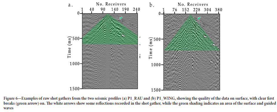
The surface seismic data collected from the WING and the RAU demonstrated clear first arrivals and discernible reflections (Figure 6). The raw shot gathers from both systems showed excellent data quality, with notable reflections and possible guided waves. The green arrows in the shot gathers indicate the P-wave first breaks, while the white arrows highlight some of the P-wave reflections. The comparison between the RAU (Figure 6a) and WING (Figure 6b) systems revealed minimal differences in data quality, confirming the efficacy of both systems in capturing high-resolution seismic data. The consistent receiver spacing and sweep parameters across profiles ensured reliable data for subsequent processing and interpretation.
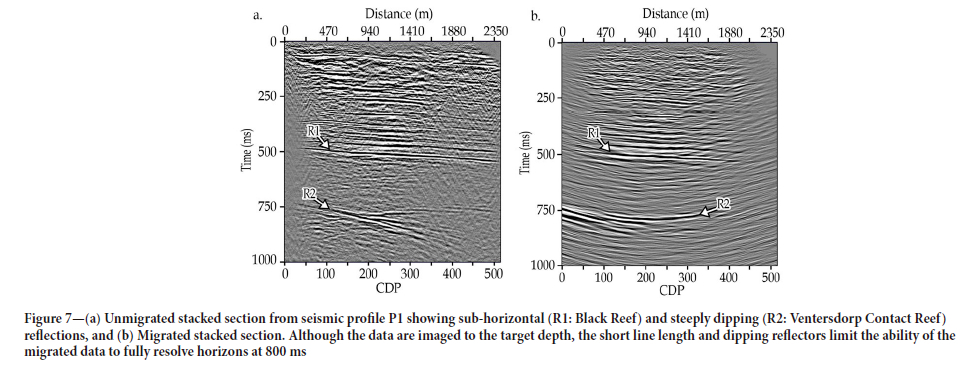
Figures 7a and 7b show the unmigrated and the migrated stacked sections, respectively, of the surface seismic profile (P1). The limited length of the profile restricts imaging to about 1000 ms (~3.2 km depth, using interval P-wave velocities of 6500 m/s). The seismic profiles show well-developed Black Reef (R1: BLR) and Ventersdorp Contact Reef (R2: VCR) reflectors, which have been extensively studied in the study area. Additionally, near-surface reflections are well imaged, providing clear detail of the upper subsurface layers. The characterisation of the BLR and VCR reflectors is detailed in Manzi et al. (2012b) using 3D seismic data, and their depths in this study corresponds to those reported in the literature.
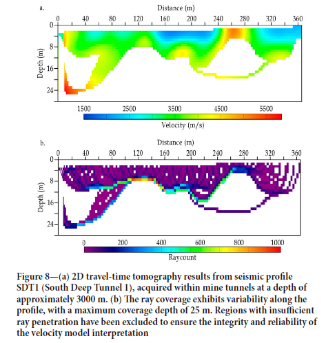
The underground seismic acquisition yielded high-quality data, despite the challenging environment. The P-wave seismic tomography results from profile SDT1 revealed three distinct P-wave velocity zones, providing valuable insights into the geological conditions of the area. The near-tunnel zone, characterised by velocities between 2000 and 3000 m/s, is indicative of fractured rock, which could correspond to zones of reduced mechanical strength and potential stability risks for mine planning. The intermediate zone, with P-wave velocities ranging from 3100 to 4400 m/s, represents more competent geological units, likely indicating less fractured and more consolidated formations. The deeper high-velocity zone (4500-5800 m/s) suggests the presence of dense, highly competent rock, which provides structural support to the mining environment (Figure 8a). The ray path coverage (Figure 8b) indicated reliable penetration to depths of 14 to 20 m, offering a robust model of the near-tunnel velocity structure. These velocity variations underscore lithological and structural heterogeneities that are critical for evaluating geotechnical conditions and ensuring the safety and efficiency of mining operations.
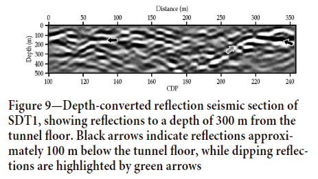
The depth-converted seismic section of SDT1 displayed significant reflections within the first 200 m below the tunnel, particularly in the central part of the section where the data fold was highest (Figure 9). These reflections likely correspond to lithological boundaries and geological structures, delineating fault zones and compartmentalised geological units. Such insights are critical for understanding stress distributions and planning mining activities to avoid hazardous areas. The complex geological setting and existing infrastructure, such as side tunnels and mine workings, influenced the recorded seismic wave-field, adding complexity to the interpretation. Integrating seismic tomography with reflection imaging and detailed geological mapping ensures comprehensive structural interpretations, enhancing safety and efficiency in mining operations. Despite these challenges, the seismic data acquired underground allowed for a meaningful structural interpretation, highlighting fault compartmentalisation and the presence of distinct geological units.
Discussion
The successful deployment of advanced seismic acquisition technologies at South Deep gold mine demonstrates the feasibility of high-resolution seismic surveys in both surface and underground environments. The comparison of nodal systems, DAS, and conventional cabled geophones provided a comprehensive dataset for analysing subsurface structures. The integration of GPS-time synchronisation and innovative data acquisition techniques ensured high accuracy and reliability, even in GPS-denied underground settings.
Seismic data acquisition for both surface and underground surveys faced several challenges from potential sources of error, primarily noise and coupling issues. For surface acquisition, nodal equipment was affected by noise from moving machinery and traffic along the survey routes. Coupling issues with the nodal receivers were mitigated by burying some sensors or ensuring that they were securely planted into the ground. DAS cables, however, faced significant coupling challenges, which were improved by covering the fibre optic cables with sand. This solution enhanced coupling but added to the deployment time. For underground acquisition, both DAS and traditional wired geophones encountered noise from mining activities, including drilling and machinery operations, and coupling issues due to the hard rock environment. Mitigation efforts, such as drilling geophones into the rock and scheduling surveys during periods of minimal traffic and halted drilling activities, significantly improved data quality and reliability.
The results underscore the potential for using seismic surveys to enhance our understanding of subsurface geology, to monitor mining-induced changes, and improve safety in mining operations.
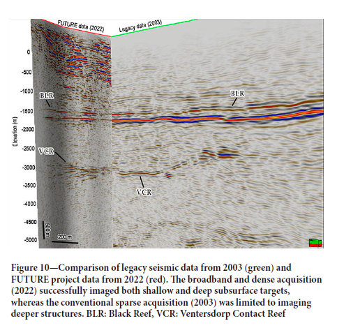
The data quality and detailed imaging achieved in this study highlight the importance of meticulous planning and execution in seismic surveys. A comparison of surface legacy seismic data collected in 2003 using traditional methods with the 2022 surface FUTURE dataset (Figure 10) underscores the advancements achieved in this study. The 2022 surface FUTURE data exhibited both near-surface and deep seismic signatures, while the legacy data primarily recovered information at larger depths. This improvement is attributed to the broadband nature of the seismic sensors and source used in the FUTURE project. The distinct P-wave velocity zones identified in the tomography provide valuable insights into the subsurface structure, that is, the stratification aids in understanding lithological variations, which are crucial for mine planning and stability assessments. The depth-converted seismic section further reveals significant reflections, indicative of lithological boundaries and fault structures. These reflections suggest the presence of fault compartmentalisation, which are critical for understanding fluid flow, ore distribution, and stress concentrations within the mining environment. The influence of existing mine infrastructure on the seismic wave-field highlights the complexity of data acquisition and interpretation in active mining operations. Overall, the velocity model and reflection seismic data contribute to a comprehensive understanding of the subsurface geology, directly informing safety measures, optimizing resource extraction, and mitigating potential geohazards. Despite the challenges posed by the underground setting, the robust structural interpretation achieved in this study demonstrates the value of integrating seismic methods into mining practices. Although a direct comparison of the underground P-wave velocities between traditional seismic methods and the methods presented in this study is not provided, the P-wave velocity model demonstrates that valuable insights can still be obtained from traditional seismic methods. The limited frequency range and sparse sensor spacing of traditional methods resulted in lower resolution. However, modern techniques, such as those used in the surface data, would have provided higher resolution imaging. The broadband and dense acquisition (FUTURE data) successfully imaged both shallow and deeper targets, addressing the limitations of conventional surveys (legacy data), which primarily focused on deeper targets while neglecting near-surface structures. Future research can build on these findings, utilizing the acquired data and methodologies to further refine seismic imaging techniques and enhance their application in the mining industry.
The use of broadband seismic sensors and a broadband source in the surface acquisition phase of the FUTURE project at South Deep gold mine significantly enhanced data quality and imaging capability. Broadband sensors, such as MEMS, capture a wide range of frequencies (4 Hz to 180 Hz), enabling detailed subsurface characterisation by resolving both deep structures with low frequencies and small-scale features with high frequencies. These sensors offer high sensitivity, low noise levels, and adaptability to various geological conditions, resulting in superior signal-to-noise ratios and clearer seismic images. The broadband mini-vibe source, with its adjustable sweep length and frequency, generated rich seismic signals, improving the resolution and penetration depth of the survey. This comprehensive frequency range facilitated better imaging of complex geological structures, essential for effective mineral exploration and accurate geological modelling. Overall, the deployment of advanced broadband technology proved invaluable for detailed and integrated subsurface investigation.
The use of DAS within the FUTURE project at the South Deep mine opened many possibilities for its application. Through permanent installation in the mine's tunnel floors and boreholes, DAS will enable continuous monitoring of seismic activity, machinery movements, and drilling operations in real-time. This proactive monitoring strategy will bolster safety measures, significantly reducing the likelihood of accidents, and fostering a secure work environment for mine workers. Additionally, DAS will play a pivotal role in optimizing operational efficiency by providing invaluable insights into machinery performance and underground conditions, ultimately leading to heightened productivity and substantial cost savings. Furthermore, the high-resolution data acquired by DAS can be used to identify potential mineral deposits with greater accuracy, guiding exploration activities within the underground tunnels. This not only benefits the mine's bottom line but also contributes to the long-term sustainability of the operation.
Conclusion
The successful implementation of advanced seismic acquisition technologies at the South Deep gold mine through the FUTURE project marks a significant milestone in the evolution of mining exploration and safety practices. By integrating state-of-the-art equipment such as nodal systems and distributed acoustic sensing (DAS) technologies, this study has demonstrated the feasibility and effectiveness of high-resolution seismic surveys in both surface and underground environments. The comparison of different acquisition methods has provided valuable insights into their respective strengths and limitations, paving the way for optimised surveying strategies in future mining efforts. The results obtained from surface and underground seismic surveys have yielded detailed imaging of subsurface geological structures and mineralisation, enhancing our understanding of the geological complexities inherent in mining operations. Moreover, the deployment of advanced broadband sensors and sources has significantly improved data quality and imaging capability, enabling better characterisation of mineral deposits and geological hazards. The implications of this research extend beyond academic research, with practical implications for enhancing operational safety, efficiency, and sustainability in the mining industry. By leveraging the insights gained from this study, mining companies can optimise exploration efforts, mitigate geological risks, and minimise environmental impacts. Furthermore, the adoption of continuous monitoring technologies like DAS promises to revolutionise safety practices by providing real-time insights into seismic activity and underground conditions. The FUTURE project represents a pioneering effort to advance seismic survey techniques, setting a benchmark for future endeavours in the mining industry. By embracing innovation and collaboration, we can chart a course towards safer, more efficient, and economically sustainable mining operations for generations to come.
Acknowledgements
This research is funded by the FUTURE project of ERA-NET Cofund on Raw Materials (ERA-MIN3), Advanced Orebody Knowledge (AOK), and DSI-NRF Centre of Excellence (CoE) for Integrated Mineral and Energy Resource Analysis (CIMERA). The Department of Science and Innovation (DSI) is greatly appreciated for funding the South African partners in the FUTURE project.
We would also like to extend our gratitude to South Deep mine of Gold Fields Ltd. for granting us permission to work at their mine and present these datasets. We also thank researchers and postgraduate students from Wits University, Uppsala University, Politecnico di Torino, and Venda University for their participation on the acquisition of the seismic data as part of the ERA-MIN3-Future Project.
We would like to thank the Council for Geoscience (CGS) for allowing us to their seismic equipment in an underground experiment.
References
Brodic, B., Malehmir, A., Pacheco, N., Juhlin, C., Carvalho, J., Dynesius, L., Van Den Berg, J., De Kunder, R., Donoso, G., Sjölund, T., Araujo, V., 2021. Innovative seismic imaging of volcanogenic massive sulfide deposits, Neves-Corvo, Portugal-Part 1: In-mine array. Geophysics, vol. 86, no. 3, pp. B165-B179. https://doi.org/10.1190/geo2020-0565.1 [ Links ]
Douglass, A.S., Ragland, J., Abadi, S. 2023. Overview of distributed acoustic sensing technology and recently acquired data sets. The Journal of the Acoustical Society of America, vol. 153 no. 3, pp. A64-A64. https://doi.org/10.1121/10.0018174 [ Links ]
Malehmir, A., Donoso, G., Markovic, M., Maries, G., Dynesius, L., Brodic, B., Pecheco, N., Marsden, P., Bäckström, E., Penney, M., Araujo, V. 2019. Smart Exploration: from legacy data to state-of-the-art data acquisition and imaging. First Break, vol. 37, no. 8, pp. 71-74. https://doi.org/10.3997/1365-2397.n0049 [ Links ]
Malehmir, A., Durrheim, R.J, Bellefleur, G., Urosevic, M., Juhlin, C., White, D. J., Milkereit, B., Campbell, G. 2012. Seismic methods in mineral exploration and mine planning: A general overview of past and present case histories and a look into the future. Geophysics, vol. 77, no. 5, pp. WC173-WC190. https://doi.org/10.1190/2012-0724-spsein.1 [ Links ]
Malehmir, A., Koivisto, E., Manzi, M., Cheraghi, S., Durrheim, R.J., Bellefleur, G., Wijns, C., Hein, K.A., King, N. 2014. A review of reflection seismic investigations in three major metallogenic regions: The Kevitsa Ni-Cu-PGE district (Finland), Witwatersrand goldfields (South Africa), and the Bathurst Mining Camp (Canada). Ore Geology Reviews, vol. 56, pp. 423-441. https://doi.org/10.1016/j.oregeorev.2013.01.003 [ Links ]
Manzi, M.S.D., Durrheim, R.J., Hein, K.A.A., King, N. 2012a. 3D edge detection seismic attributes used to map potential conduits for water and methane in deep gold mines in the Witwatersrand basin, South Africa. Geophysics, vol. 77, pp. WC133-WC147. https://doi.org/10.1190/geo2012-0135.1 [ Links ]
Manzi, M.S.D., Gibson, M.A.S., Hein, K.A.A., King, N., Durrheim, R.J. 2012b. Application of 3D seismic techniques to evaluate ore resources in the West Wits Line goldfield and portions of the West Rand goldfield, South Africa. Geophysics, vol. 77, no. 5, pp. WC163-WC171. https://doi.org/10.1190/geo2012-0133.1 [ Links ]
Mutshafa, N., Manzi, M.S.D., Westgate, M., James, I., Brodic, B., Bourdeau, J.E., Durrheim, R.J., Linzer, L. 2023. Seismic imaging of the gold deposit and geological structures through reprocessing of legacy seismic profiles near Kloof-Driefontein Complex East Mine, South Africa. Geophysical Prospecting, vol. 71, pp. 1181-1196. https://doi.org/10.1111/1365-2478.13283 [ Links ]
Pretorius, C., Trewick, W., Fourie, A., Irons, C. 2000. Application of 3-D seismics to mine planning at Vaal Reefs gold mine, number 10 shaft, Republic of South Africa. Geophysics, 65, pp. 1862-1870. https://doi.org/10.1190/1.1444870 [ Links ]
Rafi, M., Mohd Noh, K. A., Abdul Latiff, A. H., Otchere, D. A., Tackie-Otoo, B. N., Putra, A. D., Riyadi, Z. A., Asfha, D. T. 2024. Application of distributed acoustic sensing in geophysics exploration: Comparative review of single-mode and multi-mode fiber optic cables. Applied Sciences, vol. 14, no. 13, p. 5560. https://doi.org/10.3390/app14135560 [ Links ]
Rapetsoa, M., Manzi, M., James, I., Sihoyiya, M., Durrheim, R.J., Pienaar, M. 2024. Innovative seismic imaging of the platinum deposits, Maseve Mine: Surface and in-mine. Minerals, vol. 14, no. 9, p. 913. https://doi.org/10.3390/min14090913 [ Links ]
Rapetsoa, M.K., Manzi, M.S., Westgate, M., Sihoyiya, M., James, I., Onyebueke, E., Kubeka, P., Durrheim, R.J., Kgarume, T. 2022. Cost-effective in-mine seismic experiments to image platinum deposits and associated geological structures at Maseve platinum mine, South Africa. Near Surface Geophysics, vol. 20, no. 6, pp. 572-589. https://doi.org/10.1002/nsg.12216 [ Links ]
Salisbury, M.H., Harvey, C.W., Matthews, L. 2003. 1. The Acoustic Properties of Ores and Host Rocks in Hardrock Terranes, in: Hardrock Seismic Exploration, Geophysical Developments Series. Society of Exploration Geophysicists, pp. 9-19. https://doi.org/10.1190/1.9781560802396.ch1 [ Links ]
Stotter, C., Angerer, E. 2011. Evaluation of 3C microelectromechanical system data on a 2D line: Direct comparison with conventional vertical-component geophone arrays and PS-wave analysis. Geophysics, vol. 76, no. 3, pp. B79-B87. https://doi.org/10.1190/1.3561769 [ Links ]
Tellier, N., Laroche, S., Wang, H., Herrmann, P. 2021. Single-sensor acquisition without data jitter: A comparative sensor study. First Break, 39, pp. 91-99. https://doi.org/10.3997/1365-2397.fb2021007 [ Links ]
Widess, M.B. 1973. How thin is a thin bed? Geophysics, vol. 38, no. 6, pp. 1176-1180. https://doi.org/10.1190/1.1440403 [ Links ]
Willis, M.E. 2022. Distributed Acoustic Sensing for Seismic Measurements - What Geophysicists and Engineers Need to Know. Society of Exploration Geophysicists. https://doi.org/10.1190/1.9781560803850 [ Links ]
Yilmaz, Ö. 2001. Seismic Data Analysis: Processing, Inversion, and Interpretation of Seismic Data. Society of Exploration Geophysicists. https://books.google.co.za/books?id=ceu1x3JqYGUC [ Links ]
 Correspondence:
M.K. Rapetsoa
Email: moyagabo.rapetsoa@wits.ac.za
Received: 30 Jun. 2024
Revised: 5 Dec. 2024
Accepted: 16 Jan. 2025
Published: January 2025
