


Services on Demand
Journal

Article
 English (pdf)
 Article in xml format
 Article references
 Send this article by e-mail
Indicators
Related links
-
 Cited by Google
 -
 Similars in Google
Share

 Permalink
Town and Regional Planning
On-line version ISSN 2415-0495Print version ISSN 1012-280X
Town reg. plan. (Online) vol.85 Bloemfontein 2024
https://doi.org/10.38140/trp.v85i.7964
RESEARCH ARTICLE
Resilience of peri-urban wetland ecosystems: A case study of Nandoni, Limpopo province, South Africa
Veerkragtigheid van buitestedelike vleiland-ekosisteme: 'n gevallestudie van Nandoni, Limpopo-provinsie, Suid-Afrika
Resilience ea tikoloho ea libaka tse mongobo tsa peri-urban: thuto ea mohlala ea Nandoni, profinseng ea Limpopo, Afrika Boroa
Priscila BandaI; Godfrey MusvotoII; Trynos GumboIII
IPhD student, Department of Town and Regional Planning, Faculty of Engineering and the Built Environment, Durban University of Technology, Durban, 4001, South Africa. Email: priscbanda@gmail.com, ORCID: https://orcid.org/0000-0001-7485-1703
IIDepartment of Town and Regional Planning, Faculty of Engineering and the Built Environment, Durban University of Technology, Durban, 4001, South Africa. Email: godfreym@dut.ac.za, ORCID: https://orcid.org/0000-0001-7902-2752
IIIDepartment of Urban and Regional Planning, Faculty of Engineering and the Built Environment University of Johannesburg, Johannesburg, 2006, South Africa. Email: tgumbo@uj.ac.za, ORCID: https://orcid.org/0000-0003-3617-4996
ABSTRACT
Human beings tend to encroach on wetlands, particularly in peri-urban areas in developing countries, as they use their rich ecosystem services. Such practices of encroachment lead to the reduction of quality and size of water resources. There is a paucity of policy information on how to effectively manage wetlands in the face of disruption from human settlements adaptation activities. This study examines the resilience of wetland ecosystems in Nandoni's peri-urban areas in South Africa to provide mitigation strategies to inform policy and praxis on how wetlands can be effectively managed in the face of disruption from human settlements around them. The study adopted a case study research design and used the mixed methods research approach, which includes qualitative and spatial data. Data was collected through key informant interviews with purposively selected spatial planners, environmentalists, and traditional leaders. Photographic and mapping surveys were conducted to determine the impact of development on wetlands. The study found that human activities such as farming, brickmaking, and residential development have impacted on wetlands, resulting in water pollution, wetland degradation or loss of wetlands, and extinction of animal species. Findings also revealed that human extraction activities affect the spatial resilience of Nandoni, while other activities such as recreational pursuits do not have as much effect in terms of the area's level of resilience. The study recommends that policy makers and wetland users adopt sustainable strategies such as improving post-relocation support, sustainable practices in wetland management, and adaptive co-management to alleviate the impacts of adaptation activities. The latter degrade wetlands in peri-urban areas that support communities and the environment. A holistic inclusivity should be adopted among stakeholders to foster collaborative initiatives that raise awareness and enforce policies.
Keywords: Peri-urban area, urban encroachment, spatial resilience, wetland ecosystems, Nandoni
OPSOMMING
Mense betree dikwels vleilande, veral in buitestedelike gebiede van ontwikkelende lande, om die ryk ekosisteem-dienste wat dit bied, te benut. Hierdie indringing lei tot die afname in die kwaliteit en grootte van waterbronne. Daar is min beleidsinligting oor hoe vleilande effektief bestuur kan word te midde van ontwrigting deur menslike nedersettings. Hierdie studie ondersoek die veerkragtigheid van vleiland-ekosisteme in Nandoni, Suid-Afrika, met die doel om versagtingsstrategieë te ontwikkel wat beleid en praktyke inlig oor die bestuur van vleilande in die lig van menslike aktiwiteite. 'n Gevallestudie-navorsingsontwerp en gemengde-metode-navorsing is gebruik, wat kwalitatiewe en ruimtelike data insluit. Data is ingesamel deur on-derhoude met geselekteerde ruimtelike beplanners, omgewingsbewustes en tradisionele leiers, sowel as fotografíese en karteringopnames om die impak van ontwikkeling op vleilande te bepaal. Die studie het bevind dat menslike akti-witeite soos boerdery, baksteenmaak en residensiële ontwikkeling 'n negatiewe impak op vleilande gehad het, wat gelei het tot waterbesoedeling, vleilandagter-uitgang, verlies van vleilande en uitster-wing van dierespesies. Bevindinge dui aan dat menslike ontginningsaktiwiteite die ruimtelike veerkragtigheid van Nandoni beïnvloed, terwyl ontspanning-saktiwiteite minder impak het. Die studie beveel aan dat beleidmakers volhou-bare strategieë aanvaar, insluitend die bevordering van volhoubare praktyke in vleilandbestuur, ondersteuning ná hervestiging en medebestuur, om die impak van menslike aktiwiteite op vlei-lande te verlig. Holistiese inklusiwiteit onder belanghebbendes moet bevorder word om samewerking en beleidsafd-winging te versterk.
KAKARETSO
Batho ba tloaetse ho kenella libakeng tse mongobo, haholo-holo libakeng tse haufi le litoropo linaheng tse tsoelang pele, kaha ba sebelisa lits'ebeletso tsa bona tse ruileng tsa tikoloho. Mekhoa e joalo ea ho kenella e lebisa phokotsong ea bo-leng le boholo ba mehloli ea metsi. Ho na le bofokoli ba tlhahisoleseding ea maano mabapi le mokhoa oa ho laola mekhoabo ka katleho ho sa tsotellehe tsitiso ea mesebetsi ea ho ikamahanya le bolulo ba batho. Phuputso ena e hlahloba ho tiea ha tikoloho ea mekhoabo libakeng tse haufi le toropo ea Nandoni Afrika Boroa ho fana ka maano a phokotso ho tsebisa maano le praxis mabapi le hore na mekhoabo e ka laoloa ka nepo joang ha ho tobane le tsitiso e tsoang meahong ea batho e ba potileng. Boithuto bona bo amohetse moralo oa phuputso ea phu-putso 'me ea sebelisa mokhoa oa ho etsa lipatlisiso oa mekhoa e tsoakaneng, o ke-nyelletsang lintlha tsa boleng le sebaka. Lintlha li ile tsa bokelloa ka lipuisano tsa litsebi le bahlophisi ba sebaka ba kheth-iloeng ka morero, litsebi tsa tikoloho le baetapele ba setso. Liphuputso tsa litsoantso le 'mapa li ile tsa etsoa ho fumana phello ea nts'etsopele libakeng tse mongobo. Boithuto bona bo fumane hore mesebetsi ea batho joalo ka temo, ho etsa litene, le nts'etsopele ea bolulo e amme mekhoabo, e bakang tsilafalo ea metsi, ho senyeha ha mekhoabo kapa tahlehelo ea mekhoabo, le ho timela ha mefuta ea liphoofolo. Liphuputso li ile tsa boela tsa senola hore mesebetsi ea ho ntsoa ha batho e ama ho tiea ha sebaka sa Nandoni, ha mesebetsi e meng e kang ho ithabisa ha e na phello e ngata ho latela boemo ba sebaka sa ho tiea. Phuputso e khothalletsa hore baetsi ba melaoana le basebelisi ba mekhoabo ba nke maano a tsoarellang a kang ho ntlafatsa tsehetso ea ka mor'a phalliso, mekhoa ea moshoelella taolong ea me-khoabo, le tsamaiso e kopanetsoeng e ikamahanyang le maemo ho fokotsa litlamorao tsa mesebetsi ea ho ikama-hanya le maemo. Ea morao e senya mekhoabo libakeng tse haufi le litoropo tse tsehetsang sechaba le tikoloho. Kenyelletso e akaretsang e lokela ho amoheloa har'a bankakarolo ho khotha-letsa boikitlaetso ba tsebelisano-'moho bo phahamisang tlhokomeliso le ho tiisa maano.
1. INTRODUCTION
Wetland ecosystem services to surrounding local communities such as peri-urban communities are facing threats by unsustainable anthropogenic activities caused by spatial development (Pereira et al., 2024: 491). Hence, they lack sufficient inquiry as to the nature and extent of how these human activities impact on them as well as on how they are coping with the maintenance of resilience. Janse et al. (2019: 11) define wetlands as ecological systems that provide many ecosystem services to the world such as provisioning services (clean water), regulating services through adaptation to climate change and support of biodiversity, as well as cultural and supporting services. Despite their ecological and economic value, roughly two thirds of the world's natural wetlands have disappeared since 1900 (Davies et al., 2020: 594-595). This loss is continuing, mostly because of agricultural and urban development. The remaining wetlands are threatened by hydrological change and nutrient enrichment, driven by population growth, economic development, and climate change (FAO, 2011). Wetlands generally increase resilience to climate change, by buffering against droughts and floods, storing carbon and, if untouched, cooling the climate in the long term. Policymakers recognise the importance of healthy wetlands for achieving sustainable development goals and are concerned about their loss (Strokal, 2021: 70). Therefore, this provides grounds for the adoption of sustainable practices in wetland use in the development quest as far as displacement and relocation of community households are concerned, as well as in the case of mega structures such as dams.
In the case of Nandoni peri-urban area, which is on the outskirts of Thohoyandou in Limpopo province, residences in and around wetlands in the Budeli, Mutoti, and Mphego areas have been relocated. Most of the relocations in the area occurred when Nandoni dam construction took place, from 1998 to 2005. Nandoni dam was a government project implemented by the Department of Water Affairs and Forestry. The purpose of the project was to construct a dam that would provide water supply to communities in the Vhembe District. Construction of Nandoni dam affected 33 villages, including the Mutoti, Budeli, Mphego, Tshiulungoma, Dididi, Tshitomboni, Muledane, Tswinga, Maniini, and Tshaulu communities. Roughly 405 homesteads were relocated to the Nandoni peri-urban area and people settled in and around the wetlands of Budeli, Mutoti, and Mphego. These areas are administered in a communal system of land tenure where the territorial councils exercise authority over the allocation of land parcels for specific uses by individuals or organisations in the respective peri-urban villages. Despite these relocations, hardly anything is known about the level of adaptation and resilience of the wetland's ecosystems around these villages.
Various studies have been conducted on the importance and impact of wetlands on neighbouring communities and the environment in terms of the ecosystem's services. However, hardly anything has been explored in terms of their spatial resilience in peri-urban areas amid development (Finlayson & Gardner, 2020). Due to development, the relationship between various human activities should be kept in balance with nature. Wetlands surrounding the villages of Budeli, Mutoti, and Mphego are negatively affected because of expansion and encroaching development, which has led to vulnerability in these sensitive landscapes. They have been seriously altered from their original state in terms of quality and size and because of the pressure they faced due to development. This article examines the resilience of peri-urban wetlands ecosystems in the Nandoni area in Limpopo province, South Africa, to scope and map the level of spatial resilience in relation to changes in land use and land cover in 10-year periods from 1996 to 2022. The article investigates adaptation activities and their impact on Budeli, Mutoti, and Mphego peri-urban areas and proposes strategies such as improving post-relocation support through infrastructure provision, sustainable practices in wetland management, and adaptive co-management to mitigate the impact of adaptation activities and to inform policy and praxis on how they can be effectively managed in the face of disruption from human settlements.
2. LITERATURE REVIEW
2.1 Peri-urban areas
In recent years, increased attention has been paid to peri-urban development encroachment (Bryant, Russwurm & McLellan, 1982; Wiggens & Proctor, 2001; Busck et al., 2006; Qviström, 2007). The term 'peri-urban areas' has been used to describe geographical areas that lie on the urban fringe, the periphery, the inner rural, and the rural commuting zone (Bryant et al., 1982). Adam (2020) defines peri-urbanisation as the process that involves the conversion of rural land uses on the fringes of cities to urban land uses, primarily for residential development. The consequential effects of peri-urbanisation are physical, economic, and social transformation in an incremental manner (Bartels, Bruns & Simon, 2020). Despite the changes in peri-urban areas being associated with improvements in economic activities to its peri-urban settlers in the form of opportunities to tap into services rendered by the city, some scholars argue that peri-urbanisation creates inequalities in the deprivation of resources such as land and water to peri-urban settlers, due to increasing population (Abdulai et al., 2020; Chirisa et al., 2016; Ingwani, 2019; Nilsson et al., 2013). The resultant effects impinge on the residents' quality of life. The process of peri-urbanisation has different effects on the level of development of areas or regions. In developed countries such as Sweden, for example, peri-urbanisation is related to more positive social and economic transformations through the adoption of conservation, construction, and restoration of wetland policies. For example, in their spatial planning at all levels, the Swedish National Environmental Protection Agency (2000) and the European Water Directive Framework (2000) include national, regional (county administration), and local (municipal) levels of adoption (Pascual et al., 2017). In Sweden, the collaboration and synergy in wetland management in peri-urban areas such as Hasselholm, Staffanstorp, and Mariastaden enable social and economic well-being through homegrown solutions to municipal problems such as wastewater effluent (Hahn et al., 2006). Consequently, the creation of artificially created wetlands (constructed wetlands) in these peri-urban areas within Sweden has resulted in the treatment of wastewater effluent within them, leading to the discharge of clean effluent to water bodies within these areas. In contrast to the context in developing countries, peri-urbanisation is associated with disorder that emanates from sprawling development (Ravetz, Fertner & Nielsen, 2012). Effects and challenges are also context and place specific as far as peri-urbanisation is concerned. Furthermore, Smith (2022) emphasises that, in South Africa, peri-urbanisation challenges have been caused and worsened by economic, developmental, and geographical injustices of the apartheid land policy and planning.
2.2 Wetland ecosystems
Wetland ecosystems are complex adaptive systems that call for sustainability in such ecosystems and adaptive management practices that emphasise the importance of taking change into account. These systems consist of many interdependent parts that interact in many ways, giving rise to emergent, system-wide patterns that cannot be predicted from the properties of the individual system components. Furthermore, these system-wise patterns influence the behaviour of the individual system parts and their interactions with other parts, creating a feedback process that shapes the evolution of the system over time and allows it to adapt to changing contexts (Lansing, 2003: 186). In the midst of this, human beings are dependent on ecosystem services from these systems. Their utilisation produces both deliberate and unintentional impacts on these services steered by individual or collective choices within natural constraints.
Musasa and Marambanyika (2020: 682) highlight the importance of wetlands as distinct ecosystems, often flooded by water either permanently or seasonally, and vital to human life. They are critical in addressing climate change as they act as natural buffers, by controlling the intensity of floods and storm surges. They have economic value five times higher than tropical forests and provide numerous recreation activities such as fishing, bird and wildlife watching, and hiking in part because they are such a vital tourist attraction, with mostly rural economies across Africa depending on them. Globally, wetlands are being depleted three times faster than forests (Scott & Jones, 1995: 4-6). In South Africa, in particular, 48% of wetlands are critically endangered and the country has lost 50% of its original wetland area (Smith, 2022). The loss of wetlands can be attributed to many factors such as the impact of climate change, population increase and urbanisation, as well as changes in land use. The pressure from human activities is expected to increase as population grows. The Worldwide Fund for Nature cites wetland blindness as one of the reasons why wetlands are undervalued in Africa. In South Africa, for example, wetland blindness explains why wetlands were once considered valueless wastelands. The government provided incentives to farmers to convert them to agricultural land, altering and degrading them in the process (Wessels, 2022).
2.3 Resilience
Resilience is fundamentally a system property embedded in ecology (Sellberg et al., 2021). It refers to the magnitude of change or disturbance that a system can experience without shifting into an alternate state that has different structural and functional properties and supplies different bundles of the ecosystem services that benefit people (Salvia & Quaranta, 2020: 18). Examples of shifts between alternate states include transitions
from coral reefs to algae-covered rocks, from grasslands to shrub-dominated landscapes, and from clear to cloudy water in freshwater lakes. Associated with each of these shifts are changes in the supply of ecosystem services, for example fish production, grazing potential, tourism, and recreation opportunities (Allen et al., 2016: 628). The lower the resilience of an ecological system such as a wetland ecosystem, the lower the level of identity. The system's loss in identity consequently leads to its disappearance. The operationalisation of resilience is obtained by quantifying the system's identity and assessing the potential for changes in identity (Cumming, 2011: 304).
Walker et al. (2020) posit that resilience is made up of key components such as learning how to identify and avoid crossing tipping points or certain levels or thresholds whenever possible; keeping away from questionable thresholds, and acquiring knowledge about the characteristics of a system that promote resilience. The key attributes of resilience comprise the ability to adapt, change, reorganise, and cope in the midst of a disturbance (Walker, 2019). The goal of resilience is also about changing so as not to be altered. The anticipated function of resilient structures such as wetland ecosystems is responding to a disturbance, by altering its corresponding levels of its distinct parts and how they interact, which consequently changes the way it functions (Lundberg & Moberg, 2003). This would result in the same kind of system through learning from the disturbance and would acquire adaptation abilities that are different from its initial set-up. Frydenberg (2017) further emphasises that resilient systems are synonymously learning systems that build resilience to threats or disturbances in its entirety, that is, through the sum of all its individual parts that make up the system. Achieving resilience in one entity or part causes an imbalance or loss of resilience in other ways. The practice of afforestation or agricultural activities in a natural wetland ecosystem may promote ecological benefits such as green plant growth. However, it may alter the natural vegetation biosphere within the localised wetland, leading to attraction of invasive flora and fauna that may result in long-term detrimental effects.
Glicksman (2008) states that ecosystem management is another important element in maintaining resilient ecosystems such as wetlands. This is achieved by having and upholding good governance structures. In wetland ecosystems' management institutions or institutional arrangements, leadership, in the form of stakeholders involved, wetland users, policies, and the legislation that governs them, plays a pivotal role (Dechasa et al., 2021: 32). Adaptive co-management principles foster stakeholders to share responsibility among them within the system, find common ground, learn from their institutions and practices, as well as adapt and modify them for subsequent cycles. This fosters inclusion of informal, local, and traditional knowledge, formal scientific knowledge and the sharing of rights, responsibilities, and power among a diverse range of relevant stakeholders (Ruitenbeek & Cartier, 2001: 7). These interactions may occur at community, provincial, national, and international levels. Stakeholders from the government (municipalities), as well as resource users such as wetland users collaborate in a continuum of involvement varying with the different phases of the adaptive management cycle. Adopting this joint approach would provide a proactive measure to the challenges of reversing the rapid degradation of ecosystems, while meeting the high demand of the use of ecosystems services.
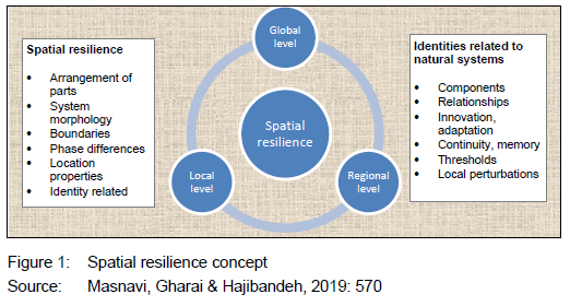
2.4 Spatial resilience theory
The spatial resilience theory brings clarity and meaning to the research findings in relation to resilience of peri-urban wetland ecosystems. Spatial resilience, a subset of resilience, refers to the ways in which spatial variation in relevant variables, both inside and outside the system of interest, influences and is influenced by system resilience across multiple spatial and temporal scales (Cumming, 2011: 21; Feliciotti et al., 2017: 72; Allen et al., 2016: 628). It has elements that are both internal and external to the system. The primary internal elements of spatial resilience include the spatial arrangement of system components and interactions; spatially relevant system properties such as system size, shape, and the number and nature of system boundaries, for example, hard or soft, and whether temporally variable or fixed over time scales of interest; spatial variation in internal phases such as the successional stage that influence resilience, and unique system properties that are a function of location in space (Cumming, 2011: 899). Furthermore, the primary external elements of spatial resilience include context that is, spatial surroundings defined at the scale of analysis, connectivity including spatial compartmentalisation or modularity, and resulting spatial dynamics such as spatially driven feedback and spatial subsidies. Both internal and external elements must be considered in relation to other aspects of system resilience, including such elements as the number and nature of components and interactions, the ability of the system to undergo change while maintaining its identity, system memory, and the potential inherent in the system for adaptation and learning (Angler & Allen, 2016: 617).
Spatial resilience is thus an interplay, at different scales, between the spatial attributes of the system and the different system constituents such as elements, interactions, adaptive capacity, memory, and history, as illustrated in Figure 1. Spatial resilience, therefore, deals with spatial variation in both internal and external influences on identity or related characteristics that are aligned to a system such as a wetland ecosystem.
In view of spatial resilience of wetland ecosystems in peri-urban areas in Nandoni, the spatial resilience theory applies in that the case involves the relocation of household communities to bring dam construction for the development of the region. The initial desired goal was to improve the level of spatial and economic resilience of the region. However, in terms of adaptation strategies in the newly resettled areas, planning was reactive rather than proactive. A regional development initiative of dam construction was meant to re-create employment or livelihoods opportunities coupled with other conservation initiatives such as nature parks fused with recreational amenities, resorts along Nandoni Dam, its tributaries and natural wetlands systems promoting conservation, while simultaneously providing employment, wild gaming as well as water recreational parks that engage in boating and canoeing. In the case of Nandoni peri-urban villages, however, there is a mismatch, leading to the unhealthy engagement with wetland ecosystems within the area.
3. STUDY AREA
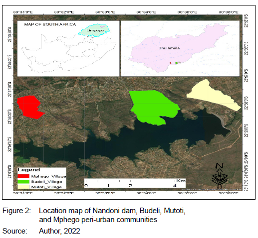
The three selected case study areas of Nandoni peri-urban areas have wetland ecosystems in the areas of Budeli, Mutoti, and Mphego, which are located on the outskirts of a small town called Thohoyandou in the Limpopo province of South Africa. Thohoyandou falls under Thulamela municipal authority jurisdiction and is situated in the south of Vhembe District, Northwest of Malamulele, on the R524 main road between Louis Trichardt and the Kruger National Park. The Livhuvhu River is situated in the northeastern part of South Africa and its catchment area extends from near Louis Trichardt in the west to the Kruger National Park in the east. Nandoni dam forms part of the Livhuvhu River Government Water Scheme (LRGWS) that supplies water for domestic use, irrigation, forestry, and ecosystem support. The aim of harnessing the river at Nandoni dam was to provide sufficient water resources to meet the requirements of the area (Department of Water Affairs and Forestry, 2003). Besides water provision, Nandoni dam offers water-based recreation and tourism development and acts as a catalyst to new development initiatives in the area. Figure 2 shows the location map of Nandoni dam, Budeli, Mutoti, and Mphego peri-urban villages.
Nandoni dam is built on state-owned land under the custodianship of the Department of Public Works and is administered in a communal system of land tenure, where the territorial councils exercise authority over allocation of land parcels for specific uses by individuals or organisations (South Africa, 2019). Moreover, Sinthumule and Netshisaulu, 2022: 1290) describe
the wetlands in Budeli, Mutoti, and Mphego as characterised by dense vegetation and heavily subdued by extreme anthropogenic challenges such as serious alteration of wetland quality and surrounding wetland habitat. Riverine bushes wetland types in these peri-urban areas have visible traces of dried-up and degraded escarpments or banks resulting from high levels of water being overdrawn through water harnessing and are also experiencing cultivation among other activities.
4. METHODS AND DATA
4.1 Research design
The research study made use of a case study design to investigate mitigation strategies to inform policy and praxis on how wetlands can be effectively managed in the face of disruption from human settlements around them (Thomas, 2011). This study used a mixed methods research approach, which merged both qualitative and quantitative data (Driscoll, 2007). In this study, key informant interviews collected data on the experiences of the impacts of peri-urban households' relocation to wetlands. Land-cover data (forest, built-up, crop) of wetlands in the selected peri-urban communities of Budeli, Mutoti, and Mphego were mapped during 2023-2024. This research approach was ideal for the study, as it uses GIS data in conjunction with interview data to verify the extent of spatial change and the extent of change of development activities taking place in the selected peri-urban villages of Budeli, Mutoti, and Mphego.
4.2 Population, sample and response rate
The study employed purposive sampling in the selection of key informants. Rahman (2023) defines purposive sampling as a technique that identifies cases, individuals, or communities best suited to answer the research aim. Eight key informants specifically operating in environment planning and living in the wetland environment were selected. This guaranteed trustworthiness, and for this study, data saturation was reached (Hossain, Alam & Ali, 2024). Informants included four spatial planners from the Department of Physical Planning, one environmentalist from the Department of the Environment from Thulamela local municipality, and three traditional leaders from Budeli, Mutoti, and Mphego villages.
The sampling procedure for photographic image classification and interpretation involved the direct collection of training samples data from Google Earth Engine (GEE), using the point drawing tool in the GEE workspace with true colour composites (Phan, Kuch & Lehnert, 2020: 2411). A training sample is a labelled set of data that is used to inform or train a classifier and is vital to supervise image classification (Paul & Zhang, 2014: 3872). The trained classification can then be applied to new data to create a classification, for example, land-cover training data that will contain examples of each class in the study's legend such as forest, built-up, and crop. In respect of these labels, the classifier can predict the most likely land-cover class for each pixel in an image and these are categorical. The study used a three-step procedure to come up with the training sample in GEE that is, creation of new feature collections in GEE representing land-cover classes of interest, loading of the Landsat composites to use as background image and as reference, and lastly collecting and exporting the training data.
Table 1 shows the summary of the number of training points used in training classifiers in the study. The class consists of forest, built-up, and crop. The number of points used for training as per peri-urban village in Nandoni, Limpopo province, is shown per class per village.
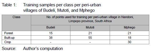
After collection in GEE as points, they were then exported in shapefile format as feature collection in GEE, and then later ingested into the same GEE environment as shapefile. The same process was used to collect validation data used in the accuracy assessment stage of the work. The data types collected included wetland type, quality, size, characteristics, spatial configuration and degree of development expansion onto wetlands, and resilience surrounding wetland ecosystems. GEE contributed many advantages to the study such as its space-saving abilities, as image analysis and classification were done in the cloud and images were downloaded at the last stage for map layout creation, guaranteeing speed and efficiency.
4.3 Data collection
The research study used primary and secondary data sources as key informant interviews from spatial planners, environmentalists, and traditional leaders, photographic surveys and mapping through QGIS Landsat satellite images during the period 2023-2024. The study used photographic images of wetlands in the selected peri-urban communities of Budeli, Mutoti, and Mphego and used GEE in image classification and interpretation. Key informant interviews complemented the surveys. The interview schedule had fourteen questions covering various issues such as awareness of wetlands close to Budeli, Mutoti, and Mphego; the status quo of these wetlands in the selected peri-urban areas; inquiry into adaptation activities practised on wetlands in the selected peri-urban areas; inquiry into the kind of activities practised in the selected peri-urban areas; the extent to which these activities have affected the wetlands close to Budeli, Mutoti, and Mphego; the level of resilience of wetlands in the selected peri-urban areas; the level of resistance to resilience of the wetlands in the selected peri-urban areas; inquiry into land-tenure system in Nandoni's peri-urban areas; the role of Thulamela local municipality in land management in the selected cases; challenges encountered; how these challenges are addressed by the local municipality in managing wetland encroachment activities in the selected peri-urban cases, and insights into better management of affected wetlands in the peri-urban areas. Secondary data used included documentation such as baseline studies on theory on wetland ecosystems frameworks; comprehensive plans and policy inclusive of the Spatial Planning and Land-use Management Act 16 of 2013; the Municipal Systems Act (2000); the Water and Sanitation Act (1997), and the Thulamela Municipality Spatial Development Framework (2019-2023) to use as benchmarks in terms of development standards that are permissible within the related peri-urban municipal jurisdiction, thereby exposing theory-praxis gaps shown in the research findings such as development encroachment beyond the floodline in Budeli and divergences from procedures such as those laid down in Environmental Impact Assessment as examples.
4.4 Data analysis and interpretation
For analysis of the spatial resilience (changes in land use and land cover), the differences in hectares were measured to calculate and report the percentage change for the three classes (forest, built-up, and crop) per peri-urban village in Nandoni for the years 1996-2022. These changes were mapped to show, for 1996-2022, the extent of change of development activities taking place in the selected peri-urban communities.
Key informant interview responses were thematically analysed (Terry et al., 2017: 25). The thematic analyses focused on development expansion activities in the peri-urban communities in Nandoni, Limpopo province, South Africa; the impacts of identified activities on wetlands practised by the local communities in the respective villages of Budeli, Mutoti, and Mphego; the extent of expansion of activities onto wetlands in the peri-urban communities of Budeli, Mutoti, and Mphego; policy strategies that can be adopted to mitigate the impacts of expanded development on wetlands, and inferences drawn or raised on spatial resilience on ecosystems in peri-urban communities in Nandoni. Photographic images and mapping were used to complement key informant interviews for more data validity and reliability.
5. FINDINGS
5.1 Spatial resilience (changes in land use and land cover) over the years in Budeli, Mutoti, and Mphego peri-urban areas in Nandoni
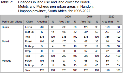
Table 2 shows the changes in land use and land cover for Budeli, Mutoti, and Mphego peri-urban areas for1996-2022 in hectares.
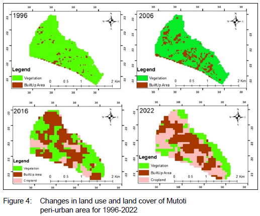
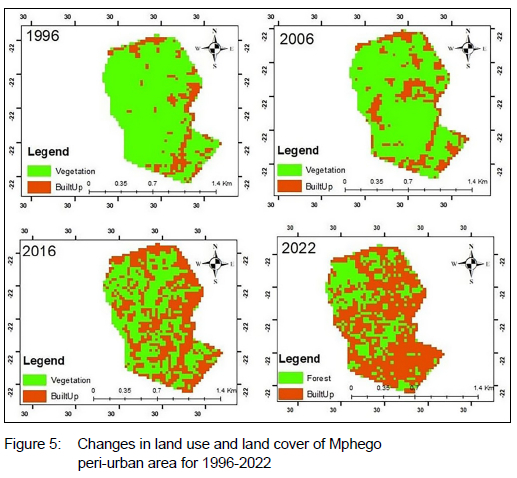
Figures 3, 4, and 5 depict the land-use and land-cover maps for Budeli, Mutoti, and Mphego peri-urban villages for 1996-2022.
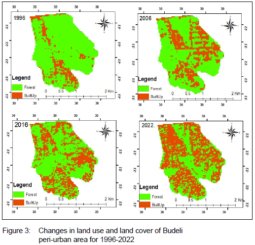
5.1.1 Level of spatial resilience (changes in land use and land cover) in 1996 in Budeli, Mutoti, and Mphego peri-urban areas
In Budeli, 289 hectares were covered with forests which is 86% compared to built-up land use cover at 14%. In Mutoti, peri-urban area forest land use cover was relatively high at 96%, but built-up land use cover was relatively low at 4%. From the 126 hectares in Mphego, 86% was forest land use coverage which is high in comparison to built-up land use cover with 14%. Mutoti's initial forest land-use coverage was the highest among the three peri-urban areas. Figures 3, 4 and 5 show that, in 1996, forest land use and land cover (green) covered a larger area within Budeli, Mutoti, and Mphego peri-urban areas.
5.1.2 Level of spatial resilience (changes in land use and land cover) in 2006 in Budeli, Mutoti, and Mphego peri-urban areas
Table 2 and Figures 3, 4, and 5 show that, in Budeli, there was a reduction in forest land use and land cover of 18% from 1996 to 2006. By contrast, built-up land use and land cover increased by 18% from 1996 to 2006. In Mutoti, for the year 2006, forest land use was high at 84%, compared to built-up land use cover at 16%. Forest land use and land cover for 2006 remained high. However, from 1996 to 2006, forest land use and land cover declined from 96% in 1996 to 84% in 2006. In Mphego, forest land use and land cover remained relatively high at 77%, compared to built-up land use and land cover of 23%. For the period 1996 to 2006, forest land use and land cover decreased by 9% and the percentage increase for built-up land use and lan cover for the same period was 8%. There was a decrease of forest land use and land cover for all three villages in 2006 from 1996, signifying an alteration or conversion of the natural landscape to facilitate the different forms of development. The level of spatial resilience is being compromised in the case of Budeli, Mutoti, and Mphego peri-urban areas to facilitate development initiatives such as residential development.
5.1.3 Level of spatial resilience (changes in land use and land cover) in 2016 in Budeli, Mutoti, and Mphego peri-urban areas
In 2016, forest land use and land cover in Budeli were relatively lower than in the built-up area, with 38% and 62%, respectively, as depicted in Table 2 and Figures 3, 4, and 5. Analysing forest land use and land cover trends from 1996, 2006 and 2016, it was found to be high initially and, in 2006, there was a general decrease to 68%. In 2016, there was a further decrease to 38%. This shows that, in Budeli, forest land use and land cover is decreasing over the 10-year period intervals. By contrast, built-up area has generally increased from 14% in 1996, 32% in 2006, and 62% in 2016. This shows that the rate of development is superseding the rate of nature conservation in terms of maintaining natural landscapes such as forests. In Mutoti, changes in forest land use and land cover, from 1996 to 2016, show a general decrease from 96%, 84%, and 33%, respectively. In terms of built-up land use and land cover, from 1996 to 2016, there was a general increase from 4%, 16%, and 19%, respectively. Of the 202 hectares in Mutoti, 48% were cropland (farming) and forest land use and land cover were higher at 33% than built-up land use and land cover at 19%.
From the 126 hectares in Mphego, forest land use and land cover, from 1996 to 2016, showed a gradual decrease from 86% to 77% and to 52%. The built-up land use and land cover from 1996 to 2016 showed a steady increase from 14% to 23%, and to 48%, respectively. This indicates a reduced level of resilience in forest land, due to changes in land use, as built-up areas are gradually replacing natural landscapes.
5.1.4 Level of spatial resilience (changes in land use and land cover) in 2022 in Budeli, Mutoti, and Mphego peri-urban areas
In 2022, forest land use and land cover in Budeli were lower than built-up land use and land cover, that is 38% and 62%, respectively, as shown in Table 2. Forest land use and land cover from 2016 to 2022 showed a constant decrease at 38%, as reflected in Figure 3 land use and land coverage map. From 2016 to 2022, built-up land use and land cover remained steadily high.
In Mutoti, forest land use and land cover were lower than built-up land use and land cover, with 30% and 50%, respectively. From 2016 to 2022, forest land use and land cover showed a slight decrease from 33% to 30%. Although croplands (farming) decreased from 48% in 2016 to 20% in 2022, built-up land use and land cover, from 2016 to 2022, increased sharply from 19% to 50%. The level of spatial resilience in Mutoti shows a decrease as built-up land use cover is exceeding forest land use and land coverage.
In Mphego, forest land use and land coverage are lower than built-up land use cover, with 47% and 53%, respectively. From 2016 to 2022, forest land use and land cover showed a slight decrease from 52% to 47%. For the same period, built-up land use and land cover showed a small increase from 48% to 53%. The spatial resilience for Mphego in 2022 was low.
5.2 Land developments in the peri-urban areas of Budeli, Mutoti, and Mphego in Nandoni
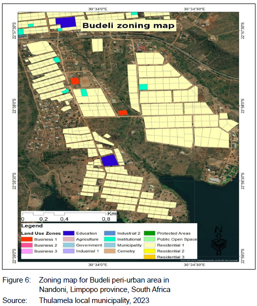
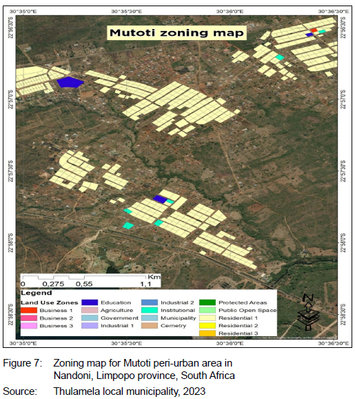
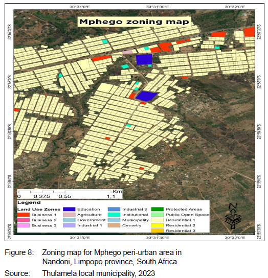
Through key informant interview responses from Thulamela local municipal authority, it was noted that the number of wetlands cannot be substantiated, since most of the wetlands that have expanded developments on them have not yet been surveyed. Hence, the developments are considered to be illegal. Figures 6, 7 and 8 show designated land developments in the peri-urban communities of Budeli, Mutoti, and Mphego. Figures 6, 7 and 8 reveal that what is reflected in policy such as zoning maps is diverging from what is being practised in the planning environments through illegal activities such as brickmaking, farming, and residential encroachment violations. Key informants provided land-use maps in support of their claims. This shows that planning is reactive rather than proactive and that planning practice is ahead of planning policy.
5.3 Level of adaptation activities in Budeli, Mutoti, and Mphego peri-urban communities in Nandoni
The study found that activities such as farming, brickmaking, residential development, recreation, and traditional medicine sourcing are being practised in Budeli, Mutoti, and Mphego peri-urban communities.
5.3.1 Farming
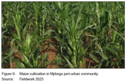
Key informant interview data findings revealed that farming activities are being practised in Budeli and Mutoti peri-urban villages. The farming activities range from animal husbandry and aquaculture to crop planting. Household communities of Budeli and Mutoti practise fishing on wetland banks and livestock such as cattle graze intensively on wetland pastures leading to overgrazing and scanty vegetation. Overgrazing has led to the deterioration and degradation of wetland vegetation quality and aesthetics. Contrasting the two peri-urban villages of Budeli and Mutoti, Mutoti displays the most dominant farming activities being practised on wetland sites in the three domains of animal husbandry, aqua-culture and crop planting. In Mphego, cultivation of crops is also practised on wetlands for livelihood purposes. Photographs clearly show the process of conversion of wetland sites into farming sites. Figure 9 shows maize cultivation in Mphego peri-urban community.
5.3.2 Brickmaking
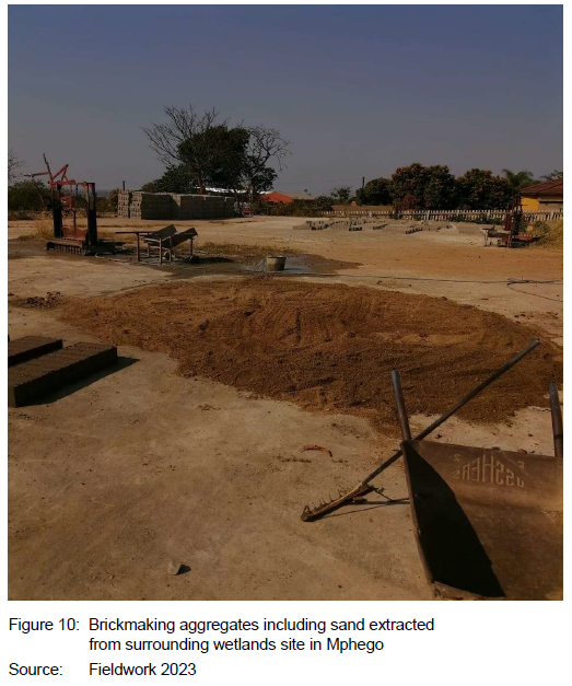
Findings from key informant interviews revealed that, in Mphego, brickmaking activities are benefiting local community households and resulting in the development and expansion of brickmaking activities on wetlands in the area. Key informant responses point out that brickmaking is deemed a mining activity and viewed as illegal by Thulamela local municipal authority. The brickmaking process involves dredging of wetland soil as well as use of water, which is compromising the quality of the wetland. Figure 10 shows a brickmaking and sand extraction site in Mphego peri-urban area in Nandoni, Limpopo province, South Africa.
5.3.3 Residential development
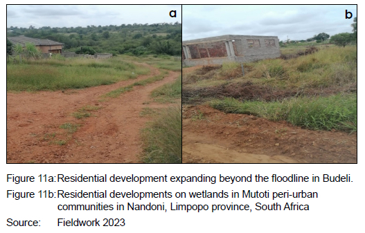
Budeli, Mutoti, and Mphego communities have benefited throughresidential development that has expanded on wetland sites, as shown by key informant interviews, photographic images and mapping (Figures 3, 4 and 5). In Budeli, some of the residential propertieshave expanded beyond the floodline. The Local Authority considers these developments illegal by law. Figure 11a shows residential development expanding beyond the floodline in Budeli. Figure 11b shows residential developments on wetlands in Mutoti peri-urban areas in Nandoni, Limpopo province, South Africa, thus validating the extent to which residential development has taken up wetland space in the quest for development.
5.3.4 Recreation
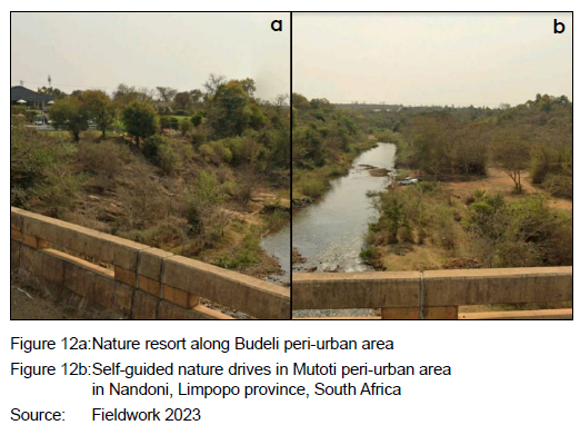
Key informant responses, photographic surveys, and mapping reveal that recreational activities take place on wetlands in Budeli and Mutoti peri-urban communities. Further examination points out that some wetlands with recreational activities are privately owned by reputable businessmen in Thohoyandou. These privately owned wetland sites attract tourists, as they offer recreational activities such as nature resorts, game reserves, nature parks and self-guided nature drives, festivals, weddings, and business events that supplement the rich vegetation diversity surrounding these wetlands. Figures 12a and 12b show recreational activities taking place on wetlands in Budeli and Mutoti peri-urban areas as well as in respect of those activities' distance to the floodline.
5.3.5 Traditional medicinal plants source
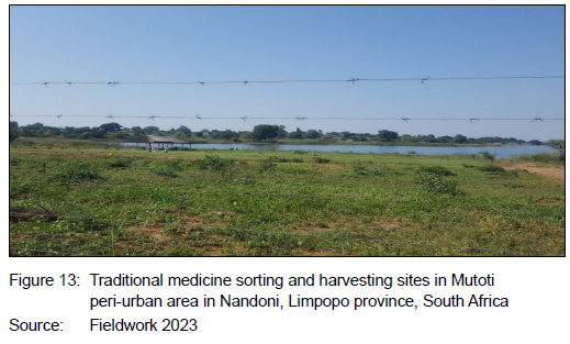
Data collected from key informant interviews shows that wetland vegetation in Mutoti peri-urban community is a rich source of traditional medicinal plants collected by traditional herbalists and the local community households. The retrieval of medicinal plants is complemented by worship practices around the wetland area. In terms of wetland ecosystem services functions, wetlandsin Mutoti are providing both provisioning and cultural ecosystem services. Figure 13 shows some local household members in Mutoti peri-urban area who have created a site where they sort harvested medicinal herbs.
5.4 Impacts of adaptation activities on wetlands in Budeli, Mutoti, and Mphego peri-urban communities
5.4.1 Modification of size and quality of wetland sites
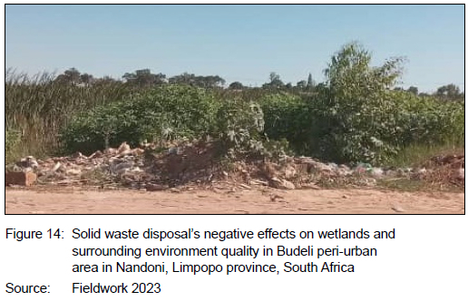
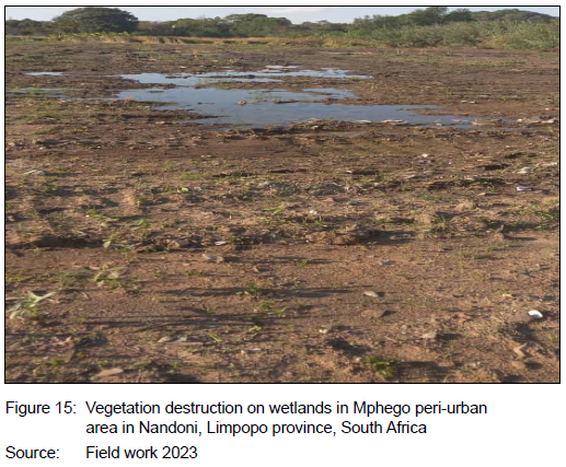
Findings from data collected from key informants and mapping through land use and land cover maps showed the negative effects on wetlands and their surroundings by activities in which local household communities engage such as alteration in size and quality of wetlands. Key informant interviews, in this instance, provided expert information, supported by land use and land cover maps in Figures 3, 4 and 5. Brickmaking in Mphego peri-urban area was highlighted as affecting wetlands in that area both intrinsically and extrinsically. The intrinsic effects included surrounding wetland pollution and scooping out of wetland soil, while the extrinsic effects included wetland bank degradation and vegetation destruction that disrupt the balance of nature. In Budeli and Mutoti, findings revealed that wetlands in these areas are experiencing solid waste disposal by local households and have assumed a dumping site role as opposed to their ecological conservative role. Figure 14 shows solid waste disposal's negative effects on wetlands and surrounding environment quality in Budeli peri-urban area in Nandoni, Limpopo province, South Africa. Figure 15 shows vegetation destruction on wetlands in Mphego peri-urban area in Nandoni, Limpopo province, South Africa.
5.4.2 Transformation of wetland sites to other uses
Findings revealed that wetland sites have been transformed to other uses such as farmland and recreational facilities in Budeli and Mutoti because of their conservative recreational nature. They are reported to be experiencing clearance of wetland vegetation, in order to accommodate recreational initiatives in these areas. Figure 4 shows the conversion of land uses from forest to crop land through mapping in Mutoti peri-urban area, for example.
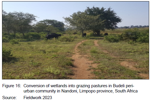
Farming practices such as livestock farming in Budeli have led to the conversion of wetland sites into livestock pasture sites that are, in turn, being affected by overgrazing. In Mphego, farming practices on seasonal inland wetlands were highlighted as not altering the wetlands but instead as leading to their disappearance. Figure 16 shows the conversion of wetlands into grazing pastures in Budeli peri-urban community in Nandoni, Limpopo province South Africa.
5.4.3 Land-tenure system
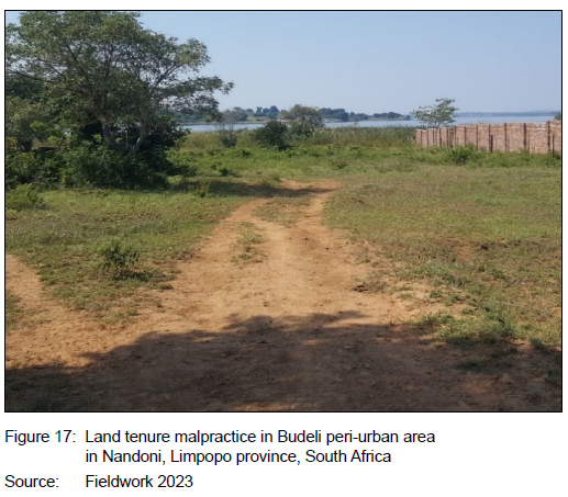
Findings revealed that the land-tenure system has acted as a catalyst for the destruction and disappearance of wetlands within the selected cases. The land-tenure system in Budeli, Mutoti, and Mphego is communal land, with traditional leaders overseeing land allocation. However, key informant inquiries and observations through photographic images revealed a misappropriation of land allocation. Findings pointed out that some development for residential or commercial purposes is deviating from the procedures laid down by the environmental impact assessment. These short-term gains are reported to lead to long-term costs to the environment. Human gains and development initiatives are given precedence over conserving the environment. Figure 17 shows an example of land-tenure malpractice in Budeli, where land developments are located in precarious areas that are detrimental to the environment, while causing danger to the households in the event of a natural disaster such as flooding.
5.5 Strategies that can be adopted in mitigating impacts of adaptation activities on wetlands in peri-urban communities in Nandoni, South Africa
5.5.1 Improving post-relocation support
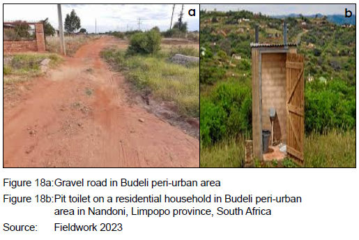
Findings revealed that stakeholders involved in land management should aim to improve relocation support for resettled people because of infrastructure development. The key informants provided substantial evidence through inquiry, revealing that in Budeli and Mutoti there is a lack of potable water in the individual residential units and households have to fetch water from nearby sources or buy drinking water. They also added that there are no portable toilets in residential units. This was viewed as learning by experience in terms of post-relocation, enabling land management enforcers to come up with an inventory list of what had been planned, and what was achieved, in order to incrementally address what had failed to materialise in the relocation process that may endanger surrounding ecological spaces such as wetland ecosystems. Figure 18 shows gravel roads and pit ablution facilities in Budeli peri-urban community. This indicates a mismatch in planning practices, where the level of development meets high standards but lacks adequate amenities on-site.
5.5.2 Sustainable practices in wetland use
Data findings through key informant inquiry and mapping pointed out the need for sustainable practices in wetland use. Sustainable practices included soil conservation, employment of irrigation, speciflcally irrigation method(s) that conserve water while simultaneously ensuring high crop yield such as drip irrigation, livelihood diversification within the peri-urban area scope, re-grassing, re-vegetation, planting trees, diversification in plant varieties particularly those that are less invasive, adoption of drought-resistant plants that have positive effects on the water level, as well as devising a planting schedule on when and what specific crop to plant per season that have less effects on water uptake whilst conserving water. It was also implied that, for sustainable practices to be operationalised, concerned institutions and stakeholders involved should be actively engaged, or be in constant communication from policy formulation to policy implementation stages, and that they should follow up processes after the implementation stage. This would curb identified expanded developments on wetlands, for example, on an incremental basis, promoting proactive responses or solutions in wetland management. It was also highlighted that, for sustainable practices to realise results, there is a need for proper enforcement systems that monitor all activities being practised on wetlands such as residential, farming, brickmaking, recreational practices, and traditional herbal medicine harvesting. In the case of the brickmaking activities in Mphego village, it was suggested that issuance of licenses and notices of non-compliance to wetland users should be clear and conclusive in litigation procedures, in order to avoid the process being viewed as a dead end. This could discourage repetition of bad practices by brickmakers.
5.5.3 Adaptive co-management
Key flndings revealed that there should be joint management in stakeholders' participation, that is related to land management by both household users and enforcers through learning by collaborating. This is reflected in key informant inquiry and through photographic images that have visible observable attributes in poor land-management decisions. Traditional leaders were encouraged to work in synergy with the local authority land custodians such as spatial planners and environmentalists, as they provide more informed land-related advisory guidelines. The synergistic approach would be backed by law through the Spatial Planning and the Land Use Management Act, Land Use schemes, the Spatial Development Framework, and the Integrated Development Plan used by Thulamela local municipality. These blueprint planning tools provide points of reference that clearly stipulate the roles of the local authority and the household community. Findings from data collected further highlighted that relocation should not be treated as a once-off event, but should have follow-up processes that follow its implementation to encourage monitoring and feedback that help solve unforeseen concerns, or that may lead to the disruption of the natural landscape, cause irreversible damage, or make adaptation or bouncing back a mammoth task.
6. POLICY RECOMMENDATIONS
Policy recommendations are mainly related to improving post-relocation support for people resettled by infrastructure development. Proactive adaptation strategies such as soil conservation through soil erosion control, employment of irrigation, specifically irrigation method(s) such as drip irrigation that conserve water while simultaneously ensuring high crop yield, livelihood diversification within the peri-urban area scope, re-grassing, re-vegetation, planting trees, diversification in plant varieties that are less invasive, adoption of drought-resistant plants, thereby impacting positively on the water level, as well as devising a planting schedule on when and what specific crop to plant per season that have less effects on water uptake while conserving water. These adaptation strategies would ensure that people live in harmony with their natural landscapes such as wetlands, resulting in less detrimental effects on the surrounding spatial form and its ecosystem services such as water, soil, and vegetation This provides diagnostics to planning practices that are ahead of planning policy blueprints reflected in the zoning maps of Budeli, Mutoti, and Mphego in research findings. Adaptive co-management in land management by stakeholders involved, that is spatial planners, environmentalists, and traditional leaders, is necessary as this is more diagnostic and will lead to solving problems with a homegrown approach. Joint management would ensure learning through collaboration in decision-making, conflict resolution or the management process. This would, in turn, enhance spatial resilience and manage wetland ecosystems complexities that transcend multiple levels and scales through the implementation of diversified conservative practices that have less effects on the environment or natural environment such as resorts, gaming, and bird watching. This would also enhance learning by doing and joint management, in other words, local and scientific knowledge, sharing of rights, responsibilities, and power by relevant stakeholders at multiple scales. Another key policy recommendation is the adoption of sustainable practices that sustain both the household communities and their surrounding ecological landscape such as wetlands. An inclusive approach in land-allocation issues between the local municipal authority and traditional leaders should be practised, thus curbing the shortfalls of the current land-tenure system. Conclusive litigation procedures in enforcement would help in submitting a definite penalty for non-compliance of wetland users in the case of mining activities on wetlands as a way of regularising illegal mining activities in Mphego peri-urban area. Inclusion of community participatory initiatives such as the holding of imbizos can help raise awareness of wetland importance, and of how the use and extent of human activities can affect wetlands flora and fauna.
7. CONCLUSION
The study concludes that there are expanded development activities on wetland ecosystems in Nandoni's peri-urban areas such as farming, residential development, brickmaking, recreational activities, and harvesting of herbal medicinal plants. These activities contribute both negative and positive effects to Nandoni's surrounding peri-urban fringes, and the level of spatial resilience is being affected, leading to the need for the adoption of sustainable wetland ecosystems strategies that promote spatial and economic development of the region or area. Brickmaking, farming, residential development, and medicinal herb harvesting activities cause negative impacts such as water pollution that affects the wetlands' water quality and reduces their water content, thereby affecting their size or coverage. In the case of recreational activities such as the establishment of lodges along wetlands close to the Livhuvhu river course, as well as their supporting activities, these are not causing much damage, compared to other human activities. The spatial transformation within Nandoni is the result of the intensity of certain unsustainable wetland adaptation activities, whereas some activities such as recreational activities (nature resorts, game reserves, nature parks and self-guided nature drives) have a minimal impact. Drawing from these inferences, the study acknowledges that spatial transformation of change is real and is influenced by certain drivers of change in the form of wetland activities. There is a need to maintain or strike a balance in wetland use and conservation that will minimise the negative impacts on wetlands in Nandoni's peri-urban areas.
Wetland ecosystems misuse through unsustainable adaptation practices revealed in the study findings are leading to negative impacts that compromise them as they capture and store carbon more than any other ecosystem on earth. Their drainage, depletion or destruction may cause significant carbon emissions. Findings suggested holistic inclusivity in stakeholder participation, in order to avoid illegal land allocations. For example, cooperation between local municipal authorities and traditional leaders plays a crucial role in addressing wetland disturbances that disrupt the natural balance.
The study findings provided empirical evidence through mapping the changes in land use and land cover for Budeli, Mutoti, and Mphego peri-urban areas over 10-year intervals, commencing from 1996 up to 2022. Forest land use cover dwindled for all three peri-urban areas (Budeli, Mutoti, and Mphego) from 1996 up to 2022. By contrast, built-up land use cover increased. This signifies the level of development with respect to ecological preservation. In the case of Mutoti peri-urban area, its hectarage land use and land cover for forest was initially high, and in 2016 and 2022, cropland or farming emerged as a new land use. In this instance, land use changed from forest to cropland, which seems to be adding to the ecological landscape. However, it has done more harm than good in that it involved the destruction of natural wetland vegetation to accommodate new vegetation species. The extrinsic elements that form the surrounding wetland landscape are being altered and converted into new land uses in the peri-urban areas of Budeli, Mutoti, and Mphego.
The theoretical constructs of spatial resilience advocate for the interaction of internal and external elements of the systems (in this instance, wetland ecosystems). However, internal elements are being disturbed by anthropogenic influences of human settlements, and this is being transferred to the external elements such as the structural elements of the system or the surroundings of the wetlands.
There is a negative interactive relationship between the internal and external elements of wetland ecosystems in the case of Nandoni. The lack of synergy is leading to a loss in the ability of wetland ecosystems to maintain their ability to undergo change, while maintaining their identity, system memory, and potential inherent in the system for adaptation and learning. Wetland ecosystems elements, in the case of the peri-urban areas in Nandoni, lack balance and are mismatched, affecting the nature balance of the local context. Spatial resilience is dependent on the global, regional, and local contexts in this cyclical, forward and backward interaction.
In terms of governance or policy implications in land management, Thulamela local municipality and traditional leaders of the respective villages of Budeli, Mutoti, and Mphego in Nandoni lack synergy in terms of land allocation, collaboration, and enforcement of sustainable wetland policy practices. The irregularities in land findings revealed fragmentation in power between Thulamela local authority stakeholders and traditional leaders. Traditional leaders are the custodians of land distribution in these peri-urban areas, and findings revealed that traditional leadership is crippled by greed and corruption, leading to unjust land allocation practices such as allocation on sites that are unfit for land-use development, such as in the case of the Budeli allocation of residential units beyond the floodline. Law enforcement in relation to the community households practising brickmaking in Mphego, for example, which is considered a mining activity, is being practised by the local authority. However, the deficiency in policy, in terms of which the litigation process has resulted in a dead-end, encourages the continuation of brickmaking activities. In this instance, the perpetrators are aware that they will be issued warnings or notices, but that their matter will not go further.
Land management is an important attribute in peri-urban wetland expanded developments as it helps regulate the nature of activities that certain land parcels occupy, including sensitive landscapes such as wetlands. In the study, the relocation process of affected households, due to the construction of the Nandoni dam, was aimed at bringing regional economic development through various recreational activities within the selected case studies of Budeli, Mutoti, and Mphego. However, this did not fully realise as household residents remained in the selected peri-urban areas. As a result, they resorted to livelihood adaptive strategies, in order to meet their immediate concerns through the ecosystems services provided by the wetlands near them. Planning praxis in the case of Nandoni is reactive, and findings revealed adaptive co-management and stakeholder engagement as far as the wise use of wetland ecosystems are concerned.
REFERENCES
ABDULAI, I., ENU-KWESI, F. & AGYENIM, J. 2020. Peri-urbanisation: A blessing or scourge? Journal of Planning and Land Management, 1(2), pp. 12-22. https://doi.org/10.36005/jplm.v1i2.23 [ Links ]
ADAM, D. 2020. Special report: The simulations driving the world's response to COVID-19. Nature, 580(7802), pp. 316-319. https://doi.org/10.1038/d41586-020-01003-6 [ Links ]
ALLEN, C.R., ANGELER, D.G., CUMMING, G.S., FOLKE, C., TWIDWELL, D. & UDEN, D.R. 2016. Quantifying spatial resilience. Journal of Applied Ecology, 53(3), pp. 625-635. https://doi.org/10.1111/1365-2664.12634 [ Links ]
ANGLER, D.G. & ALLEN, C. 2016. Quantifying resilience. Journal of Applied Ecology, 53, pp. 617-624. https://doi.org/10.1111/1365-2664.12649 [ Links ]
BARTELS, L.E., BRUNS, A. & SIMON, D. 2020. Towards situated analyses of uneven peri-urbanisation: An (urban) political ecology perspective. Antipode, 52(5), pp.1237-1258. https://doi.org/10.1111/anti.12632 [ Links ]
BRYANT, C.R., RUSSWURM, L.J. & MCLELLAN, A.G. 1982. The city's countryside. Land and its management in the rural-urban fringe. London, UK: Longman. [ Links ]
BUSCK, A.G., KRISTENSEN, S.P., PRÆSTHOLM, S., REENBERG, A. & PRIMDAHL, J. 2006. Land system changes in the context of urbanisation: Examples from the peri-urban area of Greater Copenhagen. Geografisk Tidsskrift/Danish Journal of Geography, 106(2), pp. 21-34. https://doi.org/10.1080/00167223.2006.10649554 [ Links ]
CHIRISA, I., BANDAUKO, E., MAZHINDU, E., KWANGWAMA, N.A. & CHIKOWORE, G. 2016. Building resilient infrastructure in the face of climate change in African cities: Scope, potentiality, and challenges. Development Southern Africa, 33(1), pp. 113-127. https://doi.org/10.1080/0376835X.2015.1113122 [ Links ]
CUMMING, G.S. 2011. Spatial resilience: Integrating landscape ecology, resilience, and sustainability. Landscape Ecology, 26, pp. 899-909. https://doi.org/10.1007/s10980-011-9623-1 [ Links ]
DAVIES, G.T., FINLAYSON, C.M., PRITCHARD, D.E., DAVIDSON, N.C., GARDNER, R.C., MOOMAW, W.R., OKUNO, E. & WHITACRE, J.C. 2020. Towards a universal declaration of the rights of wetlands. Marine and Freshwater Research, 72(5), pp. 593-600. https://doi.org/10.1071/MF20219 [ Links ]
DECHASA, F., SENBETA, F., DIRIBA, D. & WARKINEH, B. 2021. Stakeholders' actions and involvement in wetland resources management in the Central Rift Valley of Ethiopia. Ethiopian Journal of Biological Sciences, 19(1), pp. 31-60. [ Links ]
DEPARTMENT OF WATER AFFAIRS AND FORESTRY. 2003 Sustainable utilisation plan. [Online]. Available at: https://www.dws.gov.za/Documents/Other/RMP/Nandoni%20SUP%20report%20_May%202003_.pdf [Accessed: 17 Maart 2024]. [ Links ]
DRISCOLL, D. 2007. Merging qualitative and quantitative data in mixed methods research: How to and why not. Ecological and Environmental Anthropology, 3(1), pp. 18-21. [ Links ]
FAO (Food and Agriculture Organization). 2011. The state of the world's land and water resources for food and agriculture (SOLAW) -Managing systems at risk. London, UK: Earthscan. [ Links ]
FELICIOTTI, A., ROMICE, O., PORTA, S. 2017. Urban regeneration, masterplans and resilience: the case of Gorbals, Glasgow. Urban Morphology, 21(1), pp. 61-79. https://doi.org/10.51347/jum.v21i1.4063 [ Links ]
FINLAYSON, C. & GARDNER, R. 2020. Ten key issues from the Global Wetland Outlook for decision makers. Marine and Freshwater Research, 72(3), pp. 301-310. https://doi.org/10.1071/MF20079 [ Links ]
FRYDENBERG, E. 2017. Coping and the challenge of resilience. London, UK: Palgrave Macmillan. https://doi.org/10.1057/978-1-137-56924-0 [ Links ]
GLICKSMAN, R.L. 2008. Ecosystem resilience to disruptions linked to global climate change: An adaptive approach to federal land management. Nebraska Law Review, 87, pp. 833-837. https://digitalcommons.unl.edu/nlr/vol87/iss4/1 [ Links ]
HAHN, T., OLSSON, P., FOLKE, C. & JOHANSSON, K. 2006. Trustbuilding, knowledge generation and organizational innovations: The role of a bridging organization for adaptive co-management of a wetland landscape around Kristianstad, Sweden. Human Ecology, 34, pp. 573-592. https://doi.org/10.1007/s10745-006-9035-z [ Links ]
HOSSAIN, M.S., ALAM, M.K. & ALI, M.S. 2024. Phenomenological approach in the qualitative study: Data collection and saturation. ICRRD Journal, 5(2), pp. 147-172. https://doi.org/10.53272/icrrd.v5i2.4 [ Links ]
INGWANI, E. 2019. Livelihoods resilience in peri-urban communal areas of Zimbabwe. Journal of Urban Systems and Innovations for Resilience in Zimbabwe, 1(1 & 2), pp. 74-93. [ Links ]
JANSE, J.H., VAN DAM, A.A., HES, E.M., DE KLEIN, J.J., FINLAYSON, C.M., JANSSEN, A.B., VAN WIJK, D., MOOIJ, W.M. & VERHOEVEN, J.T. 2019. Towards a global model for wetlands ecosystem services. Current Opinion in Environmental Sustainability, 36, pp. 11-19. https://doi.org/10.1016/j.cosust.2018.09.002 [ Links ]
LANSING, J.S. 2003. Complex adaptive systems. Annual Review of Anthropology, 32(1), pp. 183-204. https://doi.org/10.1146/annurev.anthro.32.061002.093440 [ Links ]
LUNDBERG, J. & MOBERG, F. 2003. Mobile link organisms and ecosystem functioning: Implications for ecosystem resilience and management. Ecosystems, 6, pp. 87-98. https://doi.org/10.1007/s10021-002-0150-4 [ Links ]
MASNAVI, M.R., GHARAI, F. & HAJIBANDEH, M. 2019. Exploring urban resilience thinking for its application in urban planning: A review of literature. International Journal of Environmental Science and Technology, 16, pp. 567-582. https://doi.org/10.1007/s13762-018-1860-2 [ Links ]
MUSASA, T. & MARAMBANYIKA, T. 2020. Threats to sustainable utilization of wetland resources in Zimbabwe: A review. Wetlands Ecology and Management, 28, pp. 681-696. https://doi.org/10.1007/s11273-020-09732-1 [ Links ]
NILSSON, K., PAULEIT, S., BELL, S., AAALBERS, C. & NIELSEN, T.A.S. (Eds). 2013. Peri-urban futures: Scenarios and models for land use change in Europe. Berlin, Germany: Springer Science & Business Media. https://doi.org/10.1007/978-3-642-30529-0 [ Links ]
PASCUAL, U., BALVANERA, P., DÍAZ, S., PATAKI, G., ROTH, E., STENSEKE, M., WATSON, R.T., DESSANE, E.B., ISLAR, M., KELEMEN, E. & MARIS, V. 2017. Valuing nature's contributions to people: The IPBES approach. Current Opinion in Environmental Sustainability, 26, pp. 7-16. https://doi.org/10.1016/j.cosust.2016.12.006 [ Links ]
PAUL, S. & ZHANG, X. 2014. Small sample GEE estimation of regression parameters for longitudinal data. Statistics in Medicine, 33(22), pp. 3869-3881. https://doi.org/10.1002/sim.6198 [ Links ]
PEREIRA, P., INÁCIO, M., PINTO, L., KALINAUSKAS, M., BOGDZEVIC, K. & ZHAO, W. 2024. Mapping ecosystem services in urban and peri-urban areas. A systematic review. Geography and Sustainability, 5(3), pp. 491-509. https://doi.org/10.1016/j.geosus.2024.06.002 [ Links ]
PHAN, T.N., KUCH, V. & LEHNERT, L.W. 2020. Land cover classification using Google Earth Engine and random forest classifier - The role of image composition. Remote Sensing, 12(15), article 2411. https://doi.org/10.3390/rs12152411 [ Links ]
QVISTRÖM, M. 2007 Landscapes out of order: studying the inner urban fringe beyond the rural-urban divide. Geografiska Annaler Series B Human Geography, 89(3), pp. 269-282. https://doi.org/10.1111/j.1468-0467.2007.00253.x [ Links ]
RAHMAN, M.M. 2023. Sample size determination for survey research and non-probability sampling techniques: A review and set of recommendations. Journal of Entrepreneurship, Business and Economics, 11(1), pp. 42-62. [ Links ]
RAVETZ, J., FERTNER, C. & NIELSEN, T.S. 2012. The dynamics of peri-urbanization. In: Nilsson, K., Pauleit, S., Bell, S., Aalbers, C. & Nielsen, T.S. (Eds), Peri-urban futures: Scenarios and models for land use change in Europe. Berlin, Heidelberg: Springer, pp. 13-44. https://doi.org/10.1007/978-3-642-30529-0_2 [ Links ]
RUITENBEEK, J. & CARTIER, C.M. 2001. The invisible wand: Adaptive co-management as an emergent strategy in complex bio-economic systems. CIFOR occasional paper, 34, pp.1-47. 10.17528/cifor/000957 [ Links ]
SALVIA, R. & QUARANTA, G. 2020. Food chains and ecosystem services through a resilience lens. Cooperative pproaches for a Changing World. In: Mattas, K. (Ed.). Sustainable Food Chains and Ecosystem. Switzerland: Springer, pp. 17-34. https://doi.org/10.1007/978-3-030-39609-1_2 [ Links ]
SCOTT, D.A. & JONES, T.A. 1995. Classification and inventory of wetlands: A global overview. Vegetation, 118(1-2), pp. 3-16. https://doi.org/10.1007/BF00045186 [ Links ]
SELLBERG, M.M., QUINLAN, A., PREISER, R., MALMBORG, K. & PETERSON, G.D. 2021. Engaging with complexity in resilience practice. Ecology & Society, 26(3), article 8. https://doi.org/10.5751/ES-12311-260308 [ Links ]
SINTHUMULE, N.I. & NETSHISAULU, K.H. 2022. Wetland resource use and conservation attitudes of rural vs. urban dwellers: A comparative analysis in Thohoyandou, Limpopo province, South Africa. Water, 14(8), article 1290. https://doi.org/10.3390/w14081290 [ Links ]
SMITH, J.L. 2022. Continuing processes of uneven development in post-apartheid South Africa. African Geographical Review, 41(2), pp.168-188. 1https://doi.org/10.1080/19376812.2020.1860098 [ Links ]
SOUTH AFRICA. 2019. Thulamela Local Municipality 2019/2023 Spatial Development Framework. Pretoria: Government printer. [ Links ]
SOUTH AFRICA. Thulamela Local Municipality 2021/2022 2023/2024 Integrated Development Plan. Pretoria: Government printer. [ Links ]
SOUTH AFRICA. 2000. Municipal Systems Act, Act 32 of 2000. Pretoria: Government printer. [ Links ]
SOUTH AFRICA. 2013. Spatial Planning and Land-use Management Act, Act 16 of 2013. Pretoria: Government printer. [ Links ]
SOUTH AFRICA. 1997. Water and Sanitation Act, Act 28 of 1997. Pretoria: Government printer. [ Links ]
STROKAL, V. 2021. Transboundary rivers of Ukraine: Perspectives for sustainable development and clean water. Journal of Integrative Environmental Sciences, 18(1), pp. 67-87. https://doi.org/10.1080/1943815X.2021.1930058 [ Links ]
TERRY, G., HAYFIELD, N., CLARKE, V. & BRAUN, V. 2017. Thematic analysis. In: The SAGE handbook of qualitative research in psychology. London, UK: SAGE Publications Ltd, pp. 17-36. https://doi.org/10.4135/9781526405555.n2 [ Links ]
THOMAS, G. 2011. How to do your case study: A guide for students and researchers. London, UK: SAGE. [ Links ]
WALKER, B. 2019. Finding resilience: Change and uncertainty in nature and society. Clayton South, VIC: CSIRO Publishing. https://doi.org/10.1079/9781789241594.0000 [ Links ]
WALKER, B.H., HOLLING, C., CARPENTER, S. & KINZIG, A. 2020. Resilience, adaptability and transformability in social-ecological systems. Ecology and Society, 9(2), article 5. http://www.ecologyandsociety.org/vol9/iss2/art5/. https://doi.org/10.5751/ES-00650-090205 [ Links ]
WESSELS, N. 2022. Assessing the role of natural open spaces in ecosystem service provision for enhanced urban planning in the Global South. Unpublished PhD dissertation, Stellenbosch University, Stellenbosch, South Africa. [ Links ]
WIGGINS, S. & PROCTOR, S. 2001. How special are rural areas? The economic implications of location for rural development. Development Policy Review, 19(4), pp. 427-436. https://doi.org/10.1111/1467-7679.00142 [ Links ]
Received: February 2024
Peer reviewed and revised: July 2024
Published: December 2024
* The author(s) declared no potential conflicts of Interest with respect to the research, authorship, and/or publication of this article
