



Services on Demand
Journal

Article
 English (pdf)
 Article in xml format
 Article references
 Automatic translation
 Send this article by e-mail
Indicators
Related links
-
 Cited by Google
 -
 Similars in Google
Share

 Permalink
Town and Regional Planning
On-line version ISSN 2415-0495Print version ISSN 1012-280X
Town reg. plan. (Online) vol.86 Bloemfontein 2025
https://doi.org/10.38140/trp.v86i.8765
REVIEW ARTICLE
Spatial planning constraints in historically marginalised areas: An integrative review
Ruimtelike beplanningsbeperkings in histories gemarginaliseerde gebiede: 'N integrerende oorsig
Litšitiso tsa moralo oa sebaka ho libaka tse qheletsoeng: Tlhahlobo
Shylet NyamwanzaI; James ChakwiziraII; Michelle BeattieIII; Emaculate IngwaniIV
IDepartment of Urban and Regional Planning, University of Venda, Thohoyandou, South Africa. ROR: https://ror.org/0338xea48, Email: Shylet.Nyamwanza@univen.ac.za, ORCID: https://orcid.org/0000-0002-2354-0072
IIDepartment of Urban and Regional Planning, University of Venda, Thohoyandou, South Africa. ROR: https://ror.org/0338xea48, Email: james.chakwizira@univen.ac.za, ORCID: https://orcid.org/0000-0002-4319-1834
IIIUniversity of Highlands and Islands, UHI House Old Perth Road, Inverness, IV2 3JH, Scotland. ROR: https://ror.org/02s08xt61, Email: michelle.beattie@uhi.ac.uk, ORCID: https://orcid.org/0000-0003-2396-9992
IVDepartment of Urban and Regional Planning, University of Venda, Thohoyandou, South Africa. ROR: https://ror.org/0338xea48, Email: Emaculate.Ingwani@univen.ac.za, ORCID: https://orcid.org/0000-0001-6977-6681
ABSTRACT
Historically marginalised areas such as South African homelands experienced systemic disadvantages over time due to various factors. Several studies relating to spatial planning constraints in historically marginalised areas have been conducted worldwide. However, to date, no integrative review has been conducted to synthesise the evidence of spatial planning constraints that hinder proper planning in historically marginalised areas to achieve sustainable development. Following a systematic approach to gather and evaluate relevant literature and adhering to the guidelines of the Preferred Reporting Items for Systematic Reviews and Meta-Analyses (PRISMA), to ensure a transparent report on the purpose, methodology, and findings, this study identifies spatial planning constraints that hamper the planning of historically marginalised areas. Data was collected from different databases with only English language articles published between 2010 and 2023 being selected for the study. After sequentially narrowing the search and removing duplicates, 60 relevant papers remained, out of which 34 fulfilled the stated criteria of constituting spatial planning constraints in historically marginalised areas. Thematic analysis of the findings revealed a range of political, economic, social, governance, and public administration factors that constrain spatial planning of historically marginalised areas. These include poor policy implementation, inadequate infrastructure, resource mismanagement and inadequacy, land-tenure complexities, informality, rapid urban growth, inadequate government investment, poor energy facilities, evolving development, slow uptake, and locational factors. The study is relevant particularly to policymakers in devising strategies towards crafting targeted spatial planning implementation frameworks for historically marginalised areas.
Keywords: Historically marginalised areas, land-use planning, marginalised communities, spatial planning constraints, South African homelands, sustainable development
OPSOMMING
Histories gemarginaliseerde gebiede, soos die voormalige Suid-Afrikaanse tuislande, het sistemiese nadele oor tyd ervaar weens verskeie faktore. Hoewel verskeie internasionale studies reeds uitgevoer is oor ruimtelike beplannings-uitdagings in sulke gebiede, bestaan daar nog geen geïntegreerde oorsig wat spesifiek fokus op die beplanning van histories gemarginaliseerde gebiede nie. Hierdie studie gebruik 'n sistema-tiese benadering, met inagneming van PRISMA-riglyne, om relevante literatuur te identifiseer, evalueer en sintetiseer. Die doel is om ruimtelike beplannings-beperkings te identifiseer wat volhou-bare ontwikkeling in hierdie gebiede belemmer. Slegs Engelstalige artikels wat tussen 2010 en 2023 gepubliseer is, is uit verskeie databasisse gekies. Ná verwydering van duplikate en toepassing van insluitingskriteria, is 34 artikels geïdentifiseer wat spesifiek fokus op ruimtelike beplanningsbeperkings in histories gemarginaliseerde gebiede. Tematiese analise van die bevindinge toon 'n reeks faktore wat beplanning belemmer. Dit sluit in swak beleidsim-plementering, gebrekkige infrastruktuur, wanbestuur van hulpbronne, komplekse grondbesitstelsels, informele nederset-tings, vinnige stedelike uitbreiding, beperkte regeringsbelegging, swak energietoegang, stadige ontwikkelingsopname en lokalisasiefaktore. Hierdie studie is van besondere waarde vir beleidmakers en beplanners wat volhoubare stra-tegieë ontwikkel vir geteikende en effek-tiewe ruimtelike beplanningsraamwerke in histories gemarginaliseerde gebiede.
KAKARETSO
Libaka tse kileng tsa qheleloa ka thoko, joalo ka linaha tsa khale tsa Afrika Boroa, li bile le liphephetso tse tsitsitseng ka lebaka la mabaka a fapaneng. Le hoja liphuputso tse ngata tsa machaba li se li entsoe mabapi le mathata a moralo oa sebaka libakeng tse joalo, ha ho so ka ho etsoa kakaretso e kopaneng e tsepamisitseng maikutlo a yona ho liba-ka tsena. Thuto ena e sebelisa mokhoa o hlophisitsoeng, o latelang melaoana ea PRISMA, ho bokella, ho hlahloba le ho kopanya lingoliloeng tse amanang le sehlooho. Sepheo ke ho totobatsa litsitiso tse sitisang nts'etsopele e tsit-sitseng libakeng tse neng li qheleloa ka thoko. Lingoliloeng tsa Senyesemane tse phatlalalitsoeng pakeng tsa 2010 le 2023 feela li ile tsa hlahlojoa. Ka mor'a ho hlakola tse iphetang le ho sebelisa litekanyetso tsa ho khetha, lingoliloeng tse 34 li ile tsa amoheloa e le tsa bohlokoa. Tlhahlobo ea temothiki e bontsa lintlha tse 'maloa tse sitisang moralo, ho kenyeletsa: ho se phethahat-soe ha maano, ho hloka lisebelisoa tse ka sehloohong, tsamaiso e fokolang ea mehlodi, mathata a ngodiso ea mobu, ho ata ha meaho e seng molaong, kholo e potlakileng ea litoropo, ho se be le matsete a lekaneng a mmuso, mathata a motlakase, ho lieha ha nts'etsopele le liphephetso tsa tikoloho. Thuto ena e bohlokoa haholo ho baetsi ba maano ba batlang ho theha meralo e sebet-sang bakeng sa libaka tse kileng tsa hlokomolohuoa.
1. INTRODUCTION
One of the major global concerns in achieving sustainable development is the eradication of spatial injustices, as indicated by international frameworks such as the United Nations 2030 Agenda for Sustainable Development (UN, 2017b). This is particularly significant in historically marginalised areas such as the former South African homelands, where spatial injustices have persisted, due to apartheid-era planning legacies (Strauss 2019: 138). These conditions partly motivated the enactment of the Spatial Planning and Land-Use Management Act of 2013 (SPLUMA), which seeks to promote spatial justice through integrated and equitable spatial planning aimed at creating sustainable and liveable environments (Mashiri et al., 2017: 149). However, the realisation of these goals is often hindered by numerous spatial planning constraints (McKay, Simpson & Patel, 2017: 41). Historically marginalised areas, often shaped by historical injustices, systemic discrimination, and socio-economic disparities, frequently face unique spatial planning constraints that impact on their urban development and sustainability (Mashiri et al. 2017: 154) . These areas, which may include the South African former homelands, informal settlements, rural towns, and low-income urban neighbourhoods, have often been overlooked in mainstream spatial planning processes, leading to spatial challenges that exacerbate poverty, social exclusion, and environmental degradation (Todes & Turok 2018). Spatial planning in such areas involves more than simply organising land use; it encompasses a multidisciplinary approach aimed at addressing the deep-seated challenges related to accessibility, land ownership, infrastructure, and the provision of basic services (Kwenda, Ntuli & Mudiriza, 2020).
The historical marginalisation of these areas has produced structural inequalities that hinder their spatial development and sustainability (Albrechts 2013: 9). Segregationist policies and discriminatory zoning laws, prevalent in many parts of the world, have restricted access to essential resources and opportunities, contributing to stark contrasts in urban landscapes (Mehretu, Pigozzi & Sommers, 2000: 93). These planning constraints are not merely physical but are also intertwined with social, economic, and political factors that make holistic interventions essential (Chakwizira 2021: iii-vii). An integrative review of literature on spatial planning constraints in these areas provides valuable insights into the challenges faced and highlights best practices and strategies for equitable spatial planning.
This review explores the historical roots of spatial planning constraints and analyses the persistence of these constraints in the modern spatial planning setting. By examining global and regional case studies, this review aims to identify both the commonalities and unique aspects of spatial planning issues in marginalised communities.
2. LITERATURE REVIEW
The historically marginalised areas, which are usually characterised by limited resources, infrastructure deficits, and social inequalities, require special attention to ensure sustainable development. Understanding the spatial planning constraints faced in these areas is crucial for relevant effective spatial planning interventions.
2.1 Historical context
The literature on spatial planning constraints in historically marginalised areas highlights the complex interrelationship between historical injustices, policy legacies, socio-economic barriers, and infrastructural deficits. These communities often experience restricted spatial development and limited economic opportunities, rooted in entrenched inequalities and exclusionary policies (Todes & Turok, 2018: 41). The spatial legacy of colonialism and segregation has produced enduring forms of spatial segregation and inequality, particularly across the global South (Shackleton & Gwedla, 2021).
Colonial planning models typically prioritised the development of affluent urban cores while marginalising peripheral settlements, embedding structural disadvantages into the urban fabric (Strauss, 2019). A study of over 300 sub-Saharan African cities confirms that colonial governance significantly shaped urban spatial form (Henderson, Peng & Baruah, 2021: 12-15). For instance, cities under French colonial rule such as in Mali, Burkina Faso, and Côte d'lvoire were planned to be more compact and cohesive, due to the centralised nature of direct colonial administration (Njoh & Akiwumi, 2012: 170). In contrast, British colonies such as Ghana, Botswana, and Lesotho developed more fragmented urban forms, reflecting indirect rule and the dual governance model that preserved local authority alongside colonial control (Strauss, 2019: 84). These colonial legacies continue to influence the urban form and development trajectory of African cities nowadays.
In South Africa, these legacies were further entrenched under apartheid, which institutionalised spatial inequality through racially segregated zoning, the creation of homelands, and the fragmentation of urban settlements (Steenkamp, 2018: 9). Apartheid's rigid spatial planning model established group areas and buffer zones that entrenched urban exclusion (Harrison & Todes, 2015: 148-162; Noble & Wright, 2013: 8). Post-1994, the democratic government initiated efforts to restructure these inequalities, by integrating the ten former homelands into nine provinces and implementing spatial policies aimed at promoting equity and inclusion (Todes & Turok, 2018: 6). Key post-apartheid frameworks focused on land reform, infrastructure, economic development, and social equity (Marais & Cloete, 2016: 3).
However, reform efforts have often struggled to overcome the deep institutional dualities inherited from the past. For example, the Development Facilitation Act (DFA) aimed to address apartheid injustices but failed to fully account for the complexities of customary land tenure (Phulisani, 2019: 45). Its successor, SPLUMA, supports integrated planning but faces implementation challenges, particularly in rural areas where traditional authorities control land allocation (Marais, 2005: 7; Phulisani, 2019: 37). This dual system undermines accountability and impedes inclusive spatial governance, necessitating clearer legal harmonisation and participatory approaches to advance spatial justice (Akaateba, 2018: 4).
Addressing these spatial challenges is integral to achieving Sustainable Development Goal 11, which calls for inclusive, safe, resilient, and sustainable cities (Mangweta, Mokoele & Monama, 2022). The New Urban Agenda reinforces this, by advocating for spatial equity, universal access to adequate housing, and resilient infrastructure, especially for historically marginalised communities (UN, 2017a: 12).
2.2 Sustainable development
The concept of sustainable development, as articulated in global frameworks such as the Sustainable Development Goals (SDGs) and the New Urban Agenda (NUA), is broadly defined as development that meets the needs of the present without compromising the ability of future generations to meet their own needs (Bernaciak, 2017: 881). In the context of spatial planning, this principle is expanded to address spatial equity, inclusion, and environmental resilience. The NUA explicitly commits to "promoting equitable and affordable access to sustainable basic physical and social infrastructure for all, without discrimination" (UN, 2017a), which is crucial for historically marginalised areas that have experienced spatial and socio-economic exclusion. Similarly, SDG 11 seeks to "make cities and human settlements inclusive, safe, resilient and sustainable", with target 11.1 calling for access to adequate, safe, and affordable housing, particularly in historically marginalised areas (UN, 2017a). Furthermore, SDGs such as Goal 1 (No Poverty), Goal 6 (Clean Water and Sanitation), Goal 7 (Affordable and Clean Energy), Goal 9 (Industry, Innovation and Infrastructure), and Goal 10 (Reduced Inequalities) are integral to transforming historically marginalised areas through comprehensive spatial and socioeconomic reform (UN, 2017b) .
In South Africa, where apartheidera planning entrenched spatial inequality, these global frameworks align with the objectives of SPLUMA, which was enacted to promote inclusive and integrated spatial planning as stated in Spatial Planning Land Use Act (2013) part A(12)(i) (Republic of South Africa, 2013). However, despite SPLUMA's progressive intent, the implementation of this transformative agenda has been constrained by persistent institutional, political, and infrastructural challenges. These barriers continue to hinder effective planning and service delivery in historically marginalised areas, thereby limiting the potential impact of sustainable development efforts.
2.3 Spatial planning constraints in historically marginalised areas
Spatial planning constraints are the limitations and challenges that impede efficient spatial planning, development, and management of land and physical space within a specific area (Wapwera et al., 2015). According to Zhang et al. (2024), these can also be opportunities for improvement. The constraints can stem from regulatory, environmental, socio-economic, and infrastructural factors, each affecting the feasibility and sustainability of spatial development initiatives (Mehretu, Pigozzi & Sommers, 2000). In the United States of America, 'spaces of exclusion' such as historically marginalised ghettos arose from policies that restricted the economic, cultural, and political freedoms of residents (Mushi, 2013: 130). In Poland, spatial inequalities are still shaped by the socio-economic legacy of its division between Russia, Prussia, and Austria (Churski, Herodowicz, Konecka-Szydtowska & Perdat, 2021: 1). Across African cities, colonial urban policies continue to influence spatial structures, where colonial-imposed institutions still shape urban form (Henderson et al., 2021: 1). In sub-Saharan Africa, for example, cities under French colonial rule, such as in Mali and Côte d'Ivoire, developed with compact, centralised layouts as French authorities replaced indigenous systems with Eurocentric land practices, centralising control (Njoh & Akiwumi, 2012). In South Africa, this phenomenon has been exaggerated by a long history of racial spatial segregation, where the apartheid regime's desire to control the migrant labour system to provide cheap labour, and various spatial planning models of exclusionary zonings and policies supported unequal infrastructure development, the development of group areas, buffer areas and homelands (Steenkamp, 2018). This created an inextricably connected relationship between land, urban processes, capital, economic productivity, and the distinctive political dynamics of the country (Steenkamp, 2018). The establishment of 'homelands', through the creation of 'race group areas' remodelled South Africa's cities and constrained urbanisation (Magidimisha & Chipungu, 2019: 118). Addressing these inequalities is essential to promote urban development and support the inclusive and sustainable vision of the SDGs of the 2030 Agenda for Sustainable Development.
2.3.1 Socio-economic constraints
Socio-economic constraints refer to financial limitations and resource-related challenges that restrict or shape development, investment, and project implementation (Ukoba et al., 2024: 1). These constraints are central to understanding the challenges faced by marginalised areas in spatial planning, as they significantly affect infrastructure projects, social programmes, and spatial development, often resulting in delayed progress, scaled-back ambitions, or limited access to essential resources (Todes & Turok, 2018: 2). Insufficient funding can hinder large-scale development initiatives, limit the expansion of public services, and restrict resource allocation to critical sectors such as health, education, and infrastructure (Salet, Bertolini & Gielen, 2013). Budgetary limitations also weaken governments' capacity to respond effectively to urban challenges, affecting the quality and accessibility of public spaces and services (Wu & Gaubatz, 2013).
These constraints are compounded by persistent poverty, high unemployment rates, limited access to education, and inadequate public services, all of which undermine communities' ability to engage meaningfully in spatial planning processes (Phulisani, 2019: 3). Poverty and lack of access to capital inhibit investment in infrastructure and public services, creating a cycle of deprivation and marginalisation (Todes & Turok, 2018: 11). For example, research shows that informal settlements frequently lack adequate access to water, sanitation, and transport networks, perpetuating spatial exclusion and limiting economic opportunities (Cilliers & Victor, 2018: 31). In regions such as parts of Latin America and sub-Saharan Africa, where economic disparities are particularly severe, spatial planning interventions are often undermined by financial constraints, thereby reinforcing inequality across the urban landscape (De Satgé & Watson, 2018).
2.3.2 Environmental and health constraints
The environmental impacts of marginalised planning areas also contribute to significant health and safety risks. Poorly planned settlements are often situated in vulnerable zones prone to flooding, pollution, and other environmental hazards, which increase health risks and reduce quality of life. Research shows that marginalised communities are disproportionately affected by climate-change impacts, with limited capacity to adapt, due to the inadequacy of spatial planning frameworks that account for environmental resilience (Robledo, Gomez-Baggethun & Thompson, 2020: 142; Kandeh, Kpanake & Aboubacar, 2021: 68; Pelling, O'Brien & Matyas, 2022: 45). Studies on climate justice further emphasise that spatial planning in these areas must incorporate adaptive and preventive measures to protect these populations from environmental vulnerabilities.
2.3.3 Spatial planning participatory constraints
One of the critical barriers to equitable spatial planning is the lack of participation by local communities in the planning process. Studies show that top-down planning approaches often ignore the needs and perspectives of marginalised residents, leading to solutions that do not align with local priorities or cultural contexts (Chambers, 1997: 12; Moser & Dani, 2008: 23; Wesener, 2015: 451). On the other hand, participatory planning, where communities actively engage in decision-making processes related to spatial and urban development, has been shown to improve spatial planning outcomes, by empowering communities to take ownership of development processes and supporting social cohesion (Lemanski, 2017: 7). For example, in Cape Town, South Africa, the Violence Prevention through Urban Upgrading (VPUU) programme demonstrated the effectiveness of participatory planning, by actively involving local residents in the co-design of safer, more cohesive, and integrated neighbourhoods (Krause et al., 2014). Similarly, participatory budgeting, a democratic process in which community members directly decide how to allocate part of a public budget, has demonstrated positive results in promoting transparency and accountability. In Brazil, for example, participatory budgeting initiatives have led to more responsive and inclusive urban planning in disadvantaged areas (Abers, 2000). However, such participatory models are often resource-intensive and require strong institutional support, which is often lacking in marginalised settings.
2.3.4 Legal and institutional constraints
Legal frameworks often reinforce spatial inequality, by maintaining out-dated zoning laws, inadequate property rights, and discriminatory land-tenure systems. In many developing countries, informal settlements are not recognised legally, limiting their access to government services and legal protections (Payne, 2005). Furthermore, institutional weaknesses such as corruption and bureaucratic inefficiencies can hinder the effectiveness of spatial planning policies. For instance, studies in sub-Saharan Africa have found that weak governance structures limit the enforcement of planning regulations, resulting in unplanned urban sprawl and insufficient infrastructure development in marginalised areas (Fuseini & Kemp, 2015: 318; De Satgé & Watson, 2018: 36).
2.3.5 Political and persistent spatial legacy
The persisting spatial legacy of colonialism suggests that the spatial change and urbanisation processes of these former colonial cities cannot be divorced from their political histories (Fox, 2014). Africa is the least urbanised continent, but its urbanisation rate is growing significantly, and the continent is due to overtake Asia as the fastest-urbanising region of the world within a decade (UN, 2018b). Managing the constraints that come with this rapid transformation is a key policy challenge, yet the evidence base, particularly in the case of sub-Saharan Africa, remains limited (De Satgé & Watson, 2018).
2.4 Former homelands in South Africa
A homeland was one of the 'race group areas' which separated South Africa's population based on race during the apartheid government (Noble & Wright, 2013: 2). The former ten homelands, namely Transkei, Bophuthatswana, Ciskei, Venda, Gazankulu, KaNgwane, KwaNdebele, KwaZulu, Lebowa, and QwaQwa, ceased to exist post-1994, and were re-incorporated into the new nine provinces of a democratic South Africa (Kwenda et al., 2020). Despite government initiatives, recent studies indicate that South Africa's homeland urban centres continue to exist as 'poor island cities' (Magidimisha & Chipungu, 2019). There are still some areas with striking spatial inequalities within the borders of former homelands (Noble & Wright, 2013: 187-201).
Spatial planning is key in addressing the above persisting spatial inequalities, yet, the evidence base on spatial planning constraints that hinder the transformation of these spaces, particularly in the case of Africa, remain limited (Marais & Nel, 2019: 5). This integrative review examines the key spatial planning constraints in historically marginalised areas.
3. RESEARCH METHODOLOGY
3.1 Search strategy
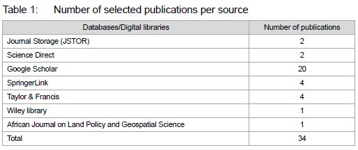
This paper employed the PRISMA integrative review tool (Figure 1) proposed by Page et al., (2021: 2) and similar to that used by Friman, Huck and Olsson (2017: 5); Moloney, Fieldes and Jacobs (2020: 3); and Gerea, Gonzalez-lopez and Herskovic (2021: 5), which made considerable contribution in their studies. The tool was used as a guideline to synthesise and analyse existing studies, theories, and findings on "spatial planning constraints in historically marginalised areas" (SPCHMA) published from 2010 to 2023. This allowed for the consideration of studies with varying methodologies to provide a clearer understanding of SPCHMA. The period selected provides the current and reliable data to understanding the present state of spatial planning constraints of the historically marginalised areas. The search was performed between 15 January 2023 and 30 June 2023. Then, the databases were explored on 11 September 2023 to extract publications relevant to SPCHMA. The search words included "Spatial planning constraints" AND "marginalised areas" OR "historically marginalised areas". Keywords were linked by Boolean words "AND" and "OR" across the databases/digital libraries. The databases/digital libraries that were used in the search for the relevant publications included the Journal Storage (JSTOR), Science Direct, Google Scholar, SpringerLink, Taylor & Francis, Wiley library, African Journal on Land Policy, and Geospatial Science (Table 1) as these have been widely used in integrative review research approaches. These databases are also subscribed to by the University of Venda and the University of Highlands and Islands, to which the authors are affiliated. The documents extracted were journal articles, conference papers, book chapters, erratum, and conference reviews.
3.2 Inclusion and exclusion criteria
Inclusion criteria:
• Papers published between 2010 to 2023.
• English-conducted studies.
• Complete papers.
• Papers with one or more spatial planning constraint in historically marginalised areas.
• Papers that focused on spatial planning constraints in historically marginalised areas.
• Peer-reviewed articles published in journals or conference proceedings.
Exclusion criteria:
• Papers without the name of the author or the date of publication.
• Papers published prior to 2010 and post-2023.
• Papers on spatial planning but mentioning nothing about spatial planning constraints in historically marginalised areas.
• Non-peer-reviewed articles published in journals or conference proceedings.
• Incomplete papers.
• Non-English papers.
3.3 Identification of studies
The reference lists of the included literature were scanned, and relevant literature included. Only full-text research papers on spatial planning constraints written in English were considered. Papers published across various disciplines on factors that hinder spatial planning and sustainable development in marginalised areas were considered, because some spatial development papers are published in management and social sciences journals. Papers on spatial planning that did not include any factors that hinder spatial planning in marginalised areas were removed. In addition, hand-searching alongside forward and backward searching of reference lists, university databases, and conferences also yielded positive results. The authors opted to include all publications disregarding the prestige of the source, privileging the paper's contribution to the topic.
3.4 Search findings
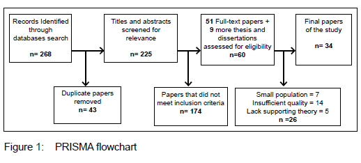
A total of 268 results from each individual database search (Google scholar [161], Journal storage [16], Science direct [13], SpringerLink [29], Taylor& Francis [32], Wiley Library [10], African Journal on Land Policy and Geospatial Science [7]) were sent to Microsoft Excel and Mendeley, where the abstract and content were subsequently analysed following the PRISMA screening criterion shown in Figure 1.
As shown in Figure 1, papers relevant to SPCHMA were selected during the initial phase, following the four-phase PRISMA integrative review guidelines. A total of 268 papers were identified, and 43 duplicates were removed, resulting in 225 unique papers. Screening titles and abstracts for relevance reduced this number to 51 papers. In addition, nine relevant papers were identified through references, university databases, and conference proceedings, including some theses and dissertations. This brought the total to 60 papers, which were subjected to content analysis to identify spatial planning constraints in marginalised areas. Full-text analysis then narrowed down the selection to 34 papers deemed most pertinent for the final analysis.
Throughout this process, crosschecking ensured that selected papers met quality standards and matched study requirements to ensure reliable findings.
3.5 Analysis of identified literature
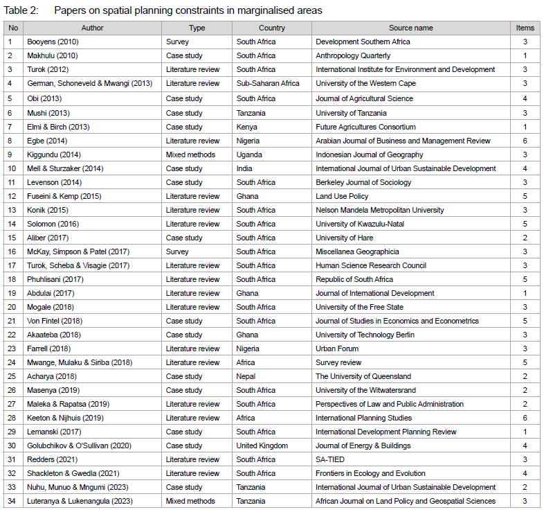
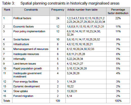
The titles and abstracts were scanned by one author, excluding the literature that did not comply with the inclusion criteria. The full text was obtained for articles, and inclusion was subject to consensus among all four authors. First, data analysis was performed on the 34 relevant studies to identify articles on SPCHMA. They were classified according to the author(s), year of publication, type of study/research methods used, country where the study was conducted, journal/source of publication, and the number of constraints in the study. The results were reported by arranging the year of publication in ascending order (Table 3). Thereafter, results from the Identification Test (Table 1) were used as criteria to do data extraction by classifying SPCHMA. For this analysis, 15 constraints were identified, namely political factors, economic factors, poor policy implementation, social factors, infrastructure, mismanagement of resources, inadequate resources, informality, land-tenure issues, rapid population growth, inadequate government investment, poor energy facilities, dynamic development, slow uptake, and forced migration. Content analysis was used to rank each SPCHMA, by reporting the number of articles that mentioned the constraint. One author performed data extraction, and a second author checked the results.
4. RESULTS AND DISCUSSION
4.1 Classification of literature on SPCHMA
The classification of articles on spatial planning constraints that limit sustainable development in historically marginalised areas can be considered for spatial and sustainable development. Table 3 ranks the articles based on the year in which they were published.
4.1.1 Publication year and source of publication
Table 3 shows fewer articles published before 2017, with scholarly output rising in later years. This suggests that from 2010 to 2016, research on spatial planning in marginalised areas received limited attention. Factors such as low academic interest, funding constraints, or competing priorities may have contributed to this trend. The post-2017 increase reflects a growing recognition of spatial planning's importance in marginalised areas, aligning with global movements toward inclusive urban planning and sustainable development goals (City of Johannesburg, 2016: 10). The data set mainly includes 34 articles from social and management sciences, revealing a gap in journals specifically for spatial planning research. Of these, 28 are journal articles and six are thesis-derived academic papers. This distribution highlights limited specialised journals on spatial planning, especially concerning marginalised areas, indicating a reliance on broader academic disciplines for publishing.
4.1.2 Research method used
An analysis of research methods used shows that the vast majority of authors relied on literature reviews or conceptual approaches 16 (47%) and case studies 14 (41%) to study SPCHMAs, while fewer used mixed-methods designs 7 (13%) and surveys 2 (6%). Empirical studies such as those by Farrell (2018: 278) and Redders (2021: 1) on SPCHMAs employed the literature review. The limited use of mixed-methods strategies and surveys reveals a knowledge gap in this area.
4.1.3 Country of origin
Studies on SPCHMAs were in over 10 countries, with African researchers contributing 88% of the publications, and South Africa alone accounting for 53% of these. Asia published only 2 articles (14%), and the United Kingdom contributed only one. The data suggests a focus on spatial marginalisation issues in Africa, particularly in South Africa, potentially indicating a more advanced stage of research in this area. It also suggests that spatial planning constraints are more prevalent in Africa, due to the dominance of colonial rule and apartheid regime in South Africa (Shackleton & Gwedla, 2021).
4.1.4 Number of constraints in the study
An analysis of the spatial planning constraints addressed across the reviewed publications reveals inconsistencies in the depth and breadth of focus. Of the publications examined, 14 addressed three constraints, five addressed five, and another five focused on two constraints. Four studies each analysed four constraints, although these may have varied in specific focus areas. Finally, only two publications examined six constraints, suggesting a limited engagement with a comprehensive set of planning limitations across the field.
This distribution indicates a general lack of uniformity in the scope of constraints studied, potentially impacting the comparability and depth of insights into spatial planning issues. The focus on fewer constraints in most of the studies may limit the ability to fully capture the complexity of planning challenges, while only a few studies offer a more thorough analysis that could yield broader implications. This variability could indicate a need for more standardised approaches or comprehensive frameworks to analyse planning constraints consistently across studies in this area.
4.2 Spatial planning constraints in historically marginalised areas
This summary of the integrative literature reveals that numerous studies, related to spatial planning constraints in SPCHMA, from various nations have been conducted. These studies investigated the difficulties in promoting spatial development of marginalised areas for sustainable development.
4.2.1 Political factors
The analysis shows that political factors account for 22% of the spatial planning constraints identified from the literature review, making them the dominant and most significant category in the group. This suggests that political factors can play a major role in shaping the spatial planning of historically marginalised areas, as these relate to priorities set by governments (Egbe, 2014: 17). According to Elmi & Birch (2013: 6), political decisions influence resource allocation, infrastructure development, land-use policies, and community engagement. The authors indicate that, usually, governments direct more resources to relatively better-off and politically dominant areas that may reinforce spatial inequalities in historically marginalised areas. For instance, a study by Marais (2005: 29) noted that, in an attempt for South Africa's National Spatial Development Plan (NSDP) to allocate spatial government resources, areas with 'potential' and 'comparative advantage' were prioritised. Such decisions would ultimately leave historically marginalised areas lagging in spatial development. Furthermore, decisions related to spatial planning regulation such as zoning regulations, land-use policies, and environmental regulations shape the physical environment of marginalised areas. For instance, restrictive zoning laws may limit the types of businesses allowed to operate in certain neighbourhoods, affecting economic opportunities for residents. Experience from South Africa (Turok, 2012: 1; Marais & Nel, 2019: 7) reveal that previously marginalised communities suffer underdevelopment, due to restrictive measures instituted by the apartheid government. Restrictions of land ownership in Black communities meant that all the access depended on White-based decisions to afford Blacks the opportunities to make development (Von Fintel, 2018: 85).
4.2.2 Economic factors
At 11%, economic factors emerge as one of the second most prominent categories of constraints identified in the analysis. This highlights their significant potential to influence spatial planning processes in historically marginalised areas. As stated by Keeton and Nijhuis (2019), economic factors can present significant constraints on the spatial planning of historically marginalised areas as they are embedded in decisions associated with investment, infrastructure development, housing affordability, and employment opportunities. According to Kiggundu (2014: 17), limited financial resources can hinder the implementation of spatial planning initiatives aimed at developing historically marginalised areas and improving infrastructure for sustainable development. In addition, Kwenda et al. (2020: 22) highlight that high levels of unemployment and poverty pose a challenge for spatial planners in attracting investment and fostering economic development in these areas. They argue that limited job opportunities and income inequalities aggravate social inequalities and constrain efforts to improve the quality of life for communities in historically marginalised areas. Furthermore, Dodman et al. (2017: 8) indicate that limited access to capital and financial services can hinder entrepreneurship and small business development in historically marginalised areas. Lastly, Turok and Scheba (2020) explain that economic factors such as rising housing costs and limited affordable housing options can lead to housing insecurity in historically marginalised areas. Therefore, spatial planning strategies must consider the affordability of housing and ensure that residents have access to safe and affordable accommodation. For example, this can be done through inclusionary zoning policies that require developers to include a certain percentage of affordable housing units in new developments to promote socio-economic diversity.
4.2.3 Social factors
Social factors, accounting for 9% of the spatial planning constraints identified in the literature, emerge as the third most significant category. This underlines their relevance in shaping planning outcomes, particularly in historically marginalised contexts. These factors can constrain spatial planning efforts in marginalised areas, by influencing community dynamics, social cohesion, and equity considerations. Literature (Turok, 2012; Obi, 2018; von Fintel, 2018) highlights that social issues, including poverty, racial discrimination, and inadequate women empowerment, have an impact on developments in historically marginalised areas. Evidence from South Africa by Phuhlisani (2019: 3) revealed that the foundation of structural poverty in formerly marginalised areas is the uneven spatial development inequalities left over from South Africa's apartheid government. The examined research also showed that, because it was based on race, spatial inequality continues to be the most significant aspect of inequality in the vast majority of African nations. In addition, Golubchikov and O'Sullivan (2020: 1) posit that social fragmentation within marginalised areas can hinder unified planning efforts and increase social inequalities. They argue that divisions based on race, ethnicity, class, or other factors may impede collaboration and cooperation among residents, making it challenging to implement effective spatial planning interventions.
4.2.4 Infrastructure constraints
The analysis indicates that infrastructure-related constraints, comprising 7% of the identified factors, rank as one of the fourth most significant categories of factors influencing spatial planning in historically marginalised areas. Evidence by Mell & Sturzaker (2014: 81-82); McKay et al. (2017: 21), and Phulisani (2017: 9) reveals that infrastructure-related constraints can significantly impede spatial planning efforts in historically marginalised areas, affecting various aspects of development and quality of life. In his study, Egbe (2014: 20) noted that hardly any or lack of infrastructure did not support meaningful development in Nigeria's rural areas. Inadequate and/or poor infrastructure such as transportation networks, public utilities, and social amenities in historically marginalised areas can impede access to essential services and hinder economic opportunities for residents (Mogale, 2018: 40). In addition, a study by Tomlinson & Krige (1997) and Von Fintel (2018: 83) show that spatial inequity is also inherent in the physical infrastructure that has been created over many years of unequal development processes. The authors are of the view that, in order to create equitable places, it is necessary to modify the current physical infrastructure, which is inefficient, linked to social exclusion and unequal resources allocation.
4.2.5 Land-tenure issues
Land tenure (5%) is related to ownership or rights on land, and this can indeed present significant constraints to spatial planning in historically marginalised areas (Fuseini & Kemp, 2015: 309). Historically marginalised areas often face challenges related to insecure land tenure, where residents lack formal documentation or legal recognition of their land rights (Phuhlisani, 2019: 7). This phenomenon can lead to tenure insecurity, land disputes, and the threat of eviction, undermining community stability and hindering spatial planning efforts to develop and upgrade infrastructure, housing, and services. According to Cilliers & Victor (2018: 31), historically marginalised areas are characterised by informal settlements, where residents occupy land without legal tenure rights. The authors further indicate that these areas often lack basic infrastructure and services, thus, posing challenges for spatial planners in addressing housing deficiencies, improving living conditions, and ensuring sustainable urban development. A study by Nattrass and Nattrass (1990: 531) reveals that insecure land tenure can restrict residents' access to credit, financing, and investment opportunities for housing improvements and infrastructure development. Without formal land titles or tenure security, residents may be unable to use their land assets as collateral for loans or investment, thereby hindering economic opportunities and socioeconomic development in historically marginalised areas. In addition, Von Fintel (2018) noted that insecure land tenure often disproportionately affects vulnerable and marginalised groups, including women, indigenous peoples, and ethnic minorities, who may face discrimination and exclusion in land rights and access to resources. Referring to South Africa, Von Fintel (2018) found out that land ownership and control in South Africa is dictated by the apartheid system which segregated Blacks from Whites since the beginning of colonialism and that to date, Blacks are not allowed to own and control land in White-dominated communities. Areas earmarked for Black communities lack appropriate services such as clean water, roads, and other development infrastructure. In line with the above, Solomon (2016: 1) highlighted that forced resettlements, which occurred in South Africa during the apartheid regime, contributed to spatial inequality because land ownership and control were based on race.
4.2.6 Rapid urban growth
Rapid urban growth (5%) presents several challenges and constraints to spatial planning endeavours in historically marginalised areas (Turok, 2012: 14). According to Mell & Sturzaker (2014: 65), rapid urban growth demands for land lead to competition for space in marginalised areas. This can result in informal settlements, land speculation, and encroachment on environmentally sensitive areas. Such situations pose challenges for spatial planners in managing land use and promoting sustainable development (Cilliers & Victor, 2018: 38). From another perspective, rapid urban growth often leads to environmental degradation, including air and water pollution, deforestation, and loss of green spaces (Fuseini & Kemp, 2015: 310). This suggests that historically marginalised areas may bear the burden of these environmental impacts, which may further marginalise vulnerable communities and pose health risks to residents. This calls for action, if socio-economic development associated with unprecedented rapid urbanisation in developing countries is to be better managed. A concern has been raised that, if this steep urbanisation is left unmanaged, it could result in severe environmental vagaries (Denoon-Stevens & Ramaila, 2018).
4.2.7 Locational factors
Locational factors display significant constraints for spatial planning in historically marginalised areas as it impacts social, economic, and environmental dynamics (Mehretu, Pigozzi & Sommers, 2000: 91). Many marginalised areas were originally established due to historical factors such as discriminatory policies, segregation, or economic exploitation. Marginalised areas may be situated far from essential services, economic opportunities, and transportation networks (Solomon, 2016: 39). This lack of accessibility can restrict residents' ability to access employment, education, healthcare, and other amenities, thereby constraining the spatial planning options for improving quality of life. In addition, some marginalised areas are located in environmentally sensitive areas such as floodplains, hilltops, wetlands, and forests (Obi, 2018). Planning for development in such areas requires careful consideration of environmental risks and mitigation strategies, which can constrain spatial planning options of making environments liveable. This can lead to populations settling in informal settlements or temporary shelters, leading to overcrowding, land disputes, and inadequate access to basic services. Furthermore, the experience from South Africa reveals that the apartheid administration compelled the development of migrant labour, by imposing disproportionate taxes on agriculture and livestock. This restricted their incomes that could be used for spatial developments (von Fintel, 2018). Due to inadequate funding and commitment, spatial development in these underprivileged communities has remained stagnant.
4.2.8 Inadequate government investment
Government investment means national spending to create public infrastructure that is essential for long-term economic growth and societal well-being, the lack thereof presenting significant constraints to spatial planning efforts in historically marginalised areas, impacting various aspects of development and quality of life (Turok, 2012). According to Mwange, Mulaku & Siriba (2018: 199), inadequate government investment in infrastructure, which may include roads, water supply, sanitation, electricity, and public transportation in historically marginalised areas, undermines spatial planning efforts to give access to basic services, create economic opportunities, and reduce inequalities. Inadequate government investment in environmental conservation and sustainable resource management worsens environmental degradation in historically marginalised areas (Mohamed, Worku & Lika, 2020: 1). Environmental degradation leads to deforestation, soil erosion, water pollution, and loss of biodiversity, which threaten ecosystems and natural resources, undermining resilience and sustainability in marginalised communities.
The experience from South Africa is that the national spending on facilities in previously marginalised communities is very low (Denoon-Stevens & Ramaila, 2018) . Although the apartheid government used to direct roughly 1.3% of its national expenditure towards housing in marginalised areas, the figure significantly dwindled after the democratic government took power. Local municipality subsidies are targeted at servicing the urban sector and not the rural areas. As a result, spatial inequality continues to persist and emerge in previously marginalised communities.
4.2.9 Informality
Informality (5%), the presence of unregulated or unplanned development within a given space, poses significant constraints to spatial planning in historically marginalised areas as it presents challenges related to land use, infrastructure provision, governance, and socio-economic development (Akaateba, 2018: 149). Furthermore, the author indicated that a high level of informality reflects the concentration of poverty in specific places and areas, including historically marginalised areas. Among other issues, informality leads to lack of formal land rights, thereby leaving residents vulnerable to eviction, displacement, and land conflicts in historically marginalised areas (Solomon, 2016: 47). Moreover, these areas may lack access to basic services such as clean water, sanitation, electricity, and healthcare and have substandard infrastructure, including unpaved roads, lack of drainage systems, and makeshift housing. This deficit constrains spatial planning, by necessitating investments in service provision to meet the needs of marginalised populations (Keeton & Nijhuis, 2019: 232). Informality leads to settling in environmentally vulnerable areas such as floodplains, steep slopes, wetlands, or hazardous industrial zones. This increases the risk of environmental degradation and natural disasters, necessitating spatial planning interventions to mitigate these risks and promote sustainable land-use practices (Mushi, 2013: 9). Therefore, informality can be viewed as a symptom of 'underdevelopment', or inadequate investment in physical and human capital that reflects a lack of human organisation and dispersed social interactions (Dodman et al., 2017: 12). Even though informality is associated with low living standards and a lack of social safety, many government programmes are conflicted about it, as public organisations are unsure about how to react and control it, and whether it is appropriate to encourage it. This partially reflects a lack of knowledge about the forces that drive informality and a belief that these marginal activities will eventually vanish as the economy and society evolve (De Satgé & Watson, 2018: 24). It is acknowledged to some extent that informality reflects individual initiative, inventiveness, and self-determination, but there is also reluctance to penalise actions that lack official approval and disregard numerous long-standing laws. In addition, they seem to evade paying taxes and give inhabitants comfortable living and working conditions. As a result, the state has reacted to informality in a variety of ways, from piecemeal 'pro-poor' support to cold-hearted evictions and the enforcement of by-laws under the pretence of reducing crime and squalor (De Satgé & Watson, 2018: 18).
4.2.10 Dynamic developments
Ever-changing developments such as rapid urbanisation, economic transformations, and technological advancements can present both opportunities and challenges for spatial planning in historically marginalised areas (Mell & Sturzaker, 2014: 65). For instance, rapid urbanisation and economic growth may result in uneven distribution of infrastructure investments, with historically marginalised areas receiving inadequate attention and resources. This infrastructure inequality hampers spatial planning efforts, by limiting access to essential services such as transportation, water, sanitation, and healthcare for marginalised communities. In addition, evolving developments often fuel the proliferation of informal settlements and informal economic activities in historically marginalised areas (Golubchikov & Sullivan 2020: 9). Informal urbanisation poses challenges for spatial planners in regulating land use, providing basic services, and integrating informal economies into formal urban systems, leading to socio-economic disparities and governance challenges (Luteranya & Lukenangula, 2023: 445). Furthermore, they often strain governance systems and institutional capacities to manage complex urban transformations in historically marginalised areas. According to Braimoh & Onishi (2007), weak regulatory frameworks, lack of transparency, and corruption undermine spatial planning efforts and hinder effective coordination among stakeholders, leading to fragmented and inequitable development outcomes.
4.2.11 Slow uptake
Historically marginalised areas may lack access to modern ICTs such as high-speed internet that are essential for accessing information, participating in decision-making processes, and fostering economic opportunities (Golubchikov & O'Sullivan, 2020: 15). The absence of ICT infrastructure hampers spatial planning efforts, by impeding communication, data sharing, and stakeholder engagement. Slow uptake in infrastructure and service provision such as out-dated transportation systems, energy grids, and water supply networks can result in inefficiencies and service disruptions in historically marginalised areas (Wall, 2024). This undermines spatial planning efforts, by limiting access to essential services and inhibiting socioeconomic development. In terms of economic opportunities, the lack of access to modern technologies and skills development programmes hinders innovation, competitiveness, and diversification of local economies, posing challenges for spatial planners in promoting sustainable economic development. Slow uptake may contribute to environmental degradation in historically marginalised areas such as outdated waste management practices and unsustainable agricultural methods (Mogale, 2018: 615). This exacerbates environmental pressures, undermines ecosystem resilience, and poses risks to public health, necessitating spatial planning interventions to promote green technologies and sustainable resource management practices.
4.2.12 Inadequate resources
Lack of adequate resources can significantly constrain spatial planning efforts in historically marginalised areas, affecting various aspects of development and quality of life. According to Egbe (2014: 17), limited financial resources hamper the implementation of infrastructure projects, social programmes, and community development initiatives, limiting the capacity of local authorities to address the specific needs and challenges of marginalised communities. For instance, evidence by Luteranya and Lukenangula (2023: 448) reveals that, in Tanzania, Kigamboni Municipality had insufficient town planning professionals by 29%, insufficient financial resources for land compensation, and other logistics. This, according to authors, slowed down the guiding and planning effort made by Kigamboni Municipal Council as well as routine monitoring of spatial development for peri-urban areas.
4.2.13 Poor energy facilities
Historically marginalised areas may lack access to reliable electricity supply, due to inadequate energy infrastructure (Golubchikov & O'Sullivan, 2020: 8). According to the authors, this limits the potential for economic activities, hinders the provision of essential services such as healthcare and education, and affects the overall quality of life for residents. For instance, inadequate energy facilities such as unreliable or unsafe cooking fuels contribute to health risks and environmental pollution in historically marginalised areas. Dependence on traditional biomass for cooking and heating purposes exposes residents to indoor air pollution, respiratory diseases, and fire hazards (Mushi, 2013: 121). Historically marginalised areas are often disproportionately affected by climate change impacts, including extreme weather events, water scarcity, and temperature fluctuations. Poor energy facilities exacerbate vulnerability to climate risks, by limiting access to adaptive measures such as climate-resilient infrastructure, renewable energy technologies, and energy-efficient solutions (Keeton & Nijhuis, 2019).
4.2.14 Poor policy implementation
The analysis shows that, among the factors identified in the literature, poor policy implementation, accounting for 11% of the constraints, ranks among the second most significant factors influencing spatial planning in historically marginalised areas. Available literature (Kiggundu, 2014; Turok, 2017; Egbe, 2014; Farrell, 2018; Solomon, 2016) indicates that poor policy implementation presents significant constraints to spatial planning efforts in historically marginalised areas, thereby undermining the effectiveness of planning interventions and exacerbating socio-economic inequalities. This can lead to inequitable distribution of resources, with historically marginalised areas receiving inadequate funding and support for spatial planning initiatives, thereby limiting the capacity of local authorities to address the specific needs and challenges of marginalised communities, perpetuating spatial inequalities, and hindering development outcomes (Mell & Sturzaker, 2014: 83). In addition, poor policy implementation may fail to prioritise stakeholder engagement, resulting in top-down decision-making processes that marginalise community voices and overlook local knowledge and priorities (Solomon, 2016).
4.2.15 Mismanagement of resources
The analysis reveals that resource mismanagement accounts for 7% of the identified constraints, positioning it among the fourth most significant factors affecting spatial planning in historically marginalised areas. Mismanagement of resources such as land, water, and energy including unequal distribution and inefficient utilisation leads to disparities and hinders spatial planning from addressing the needs of marginalised communities (Egbe, 2014: 17). Spatial planning efforts to promote environmentally sensitive land-use practices and conservation measures are undermined if natural resources are mismanaged and may lead to environment degradation (Turok, 2012: 45).
5. CONCLUSION
This review provided a comprehensive analysis of the constraints impacting spatial planning in historically marginalised areas. Among these, political factors play a critical role, as government decision-making often exacerbates spatial inequalities. Policy choices tend to prioritise already developed areas, diverting resources away from disadvantaged communities, thus intensifying economic marginalisation. Insufficient funding, limited investment, and inadequate infrastructure perpetuate cycles of poverty and unemployment, reinforcing spatial exclusion. Structural issues such as weak land-tenure systems, inadequate institutional support, and deficient infrastructure further entrench these inequalities. Informality and social fragmentation complicate planning, leading to unregulated growth that lacks essential services and legal recognition. Rapid urbanisation, coupled with the slow uptake of innovative technologies, widens the divide between marginalised areas and urban centres, placing added strain on infrastructure and the environment. These interconnected challenges hinder effective spatial planning and sustainable development. Addressing these issues requires an integrated and equitable approach to spatial planning. Strengthening political commitment and aligning policy priorities at all levels of government is crucial. Improved intergovernmental coordination, accountability, and capacity-building for local authorities are essential for effective implementation. Transparent resource governance must be prioritised to ensure that public investments are fairly distributed and sustainably managed. Key policy strategies should include increased infrastructure investment, equitable land-use policies, and securing land tenure for vulnerable populations. International examples offer valuable insights: Brazil's Favela Bairro programme demonstrates the power of participatory planning to integrate informal settlements (Fiori, Riley & Ramirez, 2001: 85), while Vietnam's National Strategy for Sustainable Development highlights the importance of prioritising infrastructure in rural areas (Son, 2022: 142). In Africa, land reform programmes have emphasised the importance of land-tenure security, and Kenya's Green Belt Movement demonstrates the significance of environmental sustainability in spatial development (Njagi, 2022: 58). India's Panchayati Raj system exemplifies how decentralised governance can better address local needs (Johnson, 2003: 109). A holistic, participatory approach that balances social, economic, and environmental considerations is essential to achieving inclusive and sustainable spatial development. Bridging the gap between policy frameworks and implementation will be vital in addressing historical spatial inequalities and advancing a more equitable planning agenda for marginalised communities.
REFERENCES
ABDULAI, A.G. 2017. Rethinking spatial inequality in development: The primacy of power relations. Journal of International Development, 29(3), pp. 386-403. https://doi.org/10.1002/jid.3265 [ Links ]
ABERS, R.N. 2000. Inventing local democracy: Grassroots politics in Brazil. Boulder, CO: Lynne Rienner Publishers. https://doi.org/10.1515/9781626371378 [ Links ]
ACHARYA, G.D. 2018. Including the excluded: Marginalised poor communities and development practices in rural Nepal. Unpublished PhD dissertation, University of Queensland, Australia. [ Links ]
AKAATEBA, M.A. 2018. Urban planning practice under neo-customary land tenure: The interface between government agencies and traditional authorities in peri-urban Ghana. Unpublished PhD dissertation.Technische Universitaet Berlin, Germany. [ Links ]
ALBRECHTS, L. 2013. Reframing strategic spatial planning by using a coproduction perspective. Planning Theory, 12(1), pp. 46-63. https://doi.org/10.1177/1473095212452722 [ Links ]
ALIBER, M. 2017. The former Transkei and Ciskei homelands are still poor, but is there an emerging dynamism. [Online]. Available at: <https://www.eeon3x3.org/artiele/former-transkei-and-ciskei-homelands-are-still-poor-there-emerging-dynamism> [Accessed: 24 January 2025]. [ Links ]
BERNACIAK, A. 2017. The New Urban Agenda - A challenge or an opportunity for Polish cities? Economic and Environmental Studies, 17(44):879-892. https://doi.org/10.25167/ees.2017.44.15 [ Links ]
BOOYENS, I. 2010. Rethinking township tourism: Towards responsible tourism development in South African townships. Development Southern Africa, 3637. https://doi.org/10.1080/03768351003740795 [ Links ]
BRAIMOH, A.K. & ONISHI, T. 2007. Spatial determinants of urban land-use change in Lagos, Nigeria. Land Use Policy, 24(2), pp. 502-515. https://doi.org/10.1016/j.landusepol.2006.09.001 [ Links ]
CHAKWIZIRA, J. 2021. Guest editorial. Town and Regional Planning, 78, p. iii-viii. https://doi.org/10.18820/2415-0495/trp78i1.Editorial [ Links ]
CHAMBERS, R. 1997. Whose reality counts? Putting the first last. London, UK: Intermediate Technology Publications. https://doi.org/10.3362/9781780440453.000 [ Links ]
CHURSKI, P., HERODOWICZ, T., KONECKA-SZYDLOWSKA, B. & PERDAL, R. 2021. Spatial differentiation of the socio-economic development of Poland - "Invisible" historical heritage. Land, 10(11), article 1247. https://doi.org/10.3390/land10111247 [ Links ]
CILLIERS, J. & VICTOR, H. 2018. Considering spatial planning for the South African poor: An argument for 'planning with'. Town and Regional Planning, 72, pp. 29-42. https://doi.org/10.18820/2415-0495/trp72i1.3 [ Links ]
CITY OF JOHANNESBURG. 2016. Spatial Development Framework 2040. [Online]. Available at: <https://www.joburg.org.za/doeuments/> [Accessed: 16 June 2024]. [ Links ]
DENOON-STEVENS, S.P. & RAMAILA, E. 2018. Community facilities in previously disadvantaged areas of South Africa. Development Southern Africa, 35(4), pp. 432-449. https://doi.org/10.1080/0376835X.2018.1456906 [ Links ]
DE SATGÉ, R. & WATSON, V. 2018. Urban planning in the Global South. eBook ed. Cham, Switzerland: Springer International Publishing. https://doi.org/10.1007/978-3-319-69496-2 [ Links ]
DODMAN, D., LECK, H., RUSCA, M. & COLENBRANDER, S. 2017. African urbanisation and urbanism: Implications for risk accumulation and reduction. International Journal of Disaster Risk Reduction, 26, pp. 7-15. https://doi.org/10.1016/j.ijdrr.2017.06.029 [ Links ]
EGBE, E.J. 2014. Rural and community development in Nigeria: An assessment. IOSR Journal of Humanities and Social Science, 19(3), pp. 104-112. https://doi.org/10.9790/0837-1935104112 [ Links ]
ELMI, M. & BIRCH, I. 2013. Creating policy space for pastoralism in Kenya. Future Agricultures Working Paper 068. Nairobi, Kenya. [ Links ]
FARRELL, K. 2018. An inquiry into the nature and causes of Nigeria's rapid urban transition. Urban Forum, 29(3), pp. 277-298. https://doi.org/10.1007/s12132-018-9335-6 [ Links ]
FIORI, J., RILEY, E. & RAMIREZ, R. 2001. Physical upgrading of, and social integration in Rio de Janeiro: The case of Favela Bairro. disP-The Planning Review, 37(147), pp. 48-60. https://doi.org/10.1080/02513625.2001.10556788 [ Links ]
FOX, S. 2014. The political economy of slums: Theory and evidence from sub-Saharan Africa. World Development, 54, pp. 191-203. https://doi.org/10.1016/j.worlddev.2013.08.005 [ Links ]
FRIMAN, M., HUCK, J. & OLSSON, L.E. 2017. Transtheoretical model of change during travel behavior interventions: An integrative review. International Journal of Environmental Research and Public Health, 14(6), pp. 1-15. https://doi.org/10.3390/ijerph14060581 [ Links ]
FUSEINI, I. & KEMP, J. 2015. A review of spatial planning in Ghana's socio-economic development trajectory: A sustainable development perspective. Land Use Policy, 47, pp. 309-320. https://doi.org/10.1016/j.landusepol.2015.04.020 [ Links ]
GEREA, C., GONZALEZ-LOPEZ, F. & HERSKOVIC, V. 2021. Omnichannel customer experience and management: An integrative review and research agenda. Sustainability (Switzerland), 13(5), pp. 1-24. https://doi.org/10.3390/su13052824 [ Links ]
GERMAN, L., SCHONEVELD, G. & MWANGI, E. 2013. Contemporary processes of large-scale land acquisition in sub-Saharan Africa: Legal deficiency or elite capture of the rule of law? World Development, 48, pp. 1-18. https://doi.org/10.1016/j.worlddev.2013.03.006 [ Links ]
GOLUBCHIKOV, O. & O'SULLIVAN, K. 2020. Energy periphery: Uneven development and the precarious geographies of low-carbon transition. Energy and Buildings, 211, article 109818. https://doi.org/10.1016/j.enbuild.2020.109818 [ Links ]
HARRISON, P. & TODES, A. 2015. Spatial transformations in a "loosening state": South Africa in a comparative perspective. Geoforum, 61, pp. 148-162. https://doi.org/10.1016/j.geoforum.2015.03.003 [ Links ]
HENDERSON, V., PENG, C. & BARUAH, N. 2021. Colonial legacies: Shaping African cities international trade and regional economics. Journal of Economic Geography, 21(1), pp. 29-65. https://doi.org/10.1093/jeg/lbaa026 [ Links ]
JOHNSON, C. 2003. Decentralisation in India: Poverty, politics and Panchayati Raj. London, UK: Overseas Development Institute. [ Links ]
KANDEH, J., KPANAKE, L. & ABOUBACAR, M. 2021. Assessing the resilience of urban communities in sub-Saharan Africa to climate change: Insights from spatial planning practices. Urban Climate, 37, pp. 63-75. https://doi.org/10.1016/j.uelim.2021.100852 [ Links ]
KEETON, R. & NIJHUIS, S. 2019. Spatial challenges in contemporary African new towns and potentials for alternative planning strategies. International Planning Studies, 24(3-4), pp. 218-234. https://doi.org/10.1080/13563475.2019.1660625 [ Links ]
KIGGUNDU, A.T. 2014. Constraints to urban planning and management of secondary towns in Uganda. Indonesian Journal of Geography, 46(1), pp. 12-21. https://doi.org/10.22146/ijg.4986 [ Links ]
KRAUSE, M., GILES, C., SHAY, D., COOKE, J., SMITH, E., TAANI, I. & LANGE, U. 2014. Violence prevention through urban upgrading: A manual for safety as a public good. Section I: Situational Crime Prevention - Urban Design, pp. 37-50. [ Links ]
KWENDA, P., MUDIRIZA, G. & KWENDA, P. 2020. Former homeland areas and unemployment in South Africa: A decomposition approach. Institute of Labor Economies, IZA discussion paper no. 12941, Germany. [ Links ]
LEMANSKI, C. 2017. Unequal citizenship in unequal cities: Participatory urban governance in contemporary South Africa. International Development Planning Review, 39(1), pp. 15-35. https://doi.org/10.3828/idpr2017.2 [ Links ]
LEVENSON, Z. 2014. We are humans and not dogs. Berkeley Journal of Sociology, 58, pp. 14-22. [ Links ]
LUTERANYA, M. & LUKENANGULA, J.M. 2023. Informal land subdivisions and their effects on spatial development in peri-urban areas. African Journal on Land Policy and Geospatial Sciences, 6(3), pp. 2657-2664. https://doi.org/10.48346/IMISTPRSM/ajlp-gs.v6i3.39539 [ Links ]
MAGIDIMISHA, H.H. & CHIPUNGU, L. 2019. In the post-apartheid South Africa: Focus on Bantustans. In: Kukina, I. (Ed.). Proceedings of the XXVISUF International Conference Urban Form and Social Context: From Traditions to Newest Demands, 5-9 July, Krasnoyarsk: Siberian Federal University, pp. 118-128. [ Links ]
MAKHULU, A.M. 2010. The "dialectics of toil": Reflections on the politics of space after apartheid. Anthropological Quarterly, 83(3), pp. 551-580. https://doi.org/10.1353/anq.2010.0004 [ Links ]
MALEKA, A.K. & RAPATSA, L.M. 2019. South Africa's legal framework on spatial planning and development: A historical and constitutional context. Perspectives of Law and Public Administration, 10(2), pp. 86-95. [ Links ]
MANGWETA, R., MOKOELE, N.J. & MONAMA, S.A. 2022. Building sustainable cities to address urban sprawl: A reflective analysis towards achieving SDGs. EUREKA: Social and Humanities, (6), pp. 72-78. https://doi.org/10.21303/2504-5571.2022.002704 [ Links ]
MARAIS, L. 2005. Housing in former homeland areas of South Africa: Delivery, issues and policy in the Free State province. In: Proceedings of the World Congress on Housing: Transforming Housing Environments through Design, 27-30 September, Pretoria: South Africa: International Association of Hydrology, pp. 1-8. [ Links ]
MARAIS, L. & CLOETE, J. 2016. Patterns of territorial development and inequality from South Africa's periphery: Evidence from the Free State province. Working Paper no. 188 for the Territorial Cohesion for Development Working Group. Santiago, Chile. [ Links ]
MARAIS, L. & NEL, V. 2019. Space and planning in secondary cities: Reflections from South Africa. Johannesburg: University of Johannesburg Press. [ Links ]
MASENYA, L. 2019. Poverty in South Africa: An analysis of former vs non-former homeland areas. Unpublished Masters study, University of the Witwatersrand, South Africa. [ Links ]
MASHIRI, M., NJENGA, P., NJENGA, C., CHAKWIZIRA, J. & FRIEDRICH, M. 2017. towards a framework for measuring spatial planning outcomes in South Africa. Sociology and Anthropology, 5(2), pp. 146-168. https://doi.org/10.13189/sa.2017.050205 [ Links ]
MCKAY, T., SIMPSON, Z. & PATEL, N. 2017. Spatial politics and infrastructure development: Analysis of historical transportation data in Gauteng-South Africa (1975-2003). Miscellanea Geographica. Regional Studies on Development, 21(1), pp. 35-43. https://doi.org/10.1515/mgrsd-2017-0003 [ Links ]
MEHRETU, A., PIGOZZI, B.W. & SOMMERS, L.M. 2000. Concepts in social and spatial marginality. Geografiska Annaler, Series B: Human Geography, 82(2), pp. 89-101. https://doi.org/10.1111/j.0435-3684.2000.00076.x [ Links ]
MELL, I.C. & STURZAKER, J. 2014. Sustainable urban development in tightly constrained areas: A case study of Darjeeling, India. International Journal of Urban Sustainable Development, 6(1), pp. 65-88. https://doi.org/10.1080/19463138.2014.883994 [ Links ]
MOGALE, D.D. 2018. The status and role of provincial governance in the South African constitutional dispensation 1996-2012. Unpublished PhD dissertation. University of the Free State, South Africa. [ Links ]
MOHAMED, A., WORKU, H. & LIKA, T. 2020. Urban and regional planning approaches for sustainable governance: The case of Addis Ababa and the surrounding area changing landscape. City and Environment Interactions, 8, article 100050. https://doi.org/10.1016/j.cacint.2020.100050 [ Links ]
MOLONEY, W., FIELDES, J. & JACOBS, S. 2020. An integrative review of how healthcare organizations can support hospital nurses to thrive at work. International Journal of Environmental Research and Public Health, 17(23), pp. 1-21. https://doi.org/10.3390/ijerph17238757 [ Links ]
MOSER, C. & DANI, A. 2008. Assets, livelihoods, and social policy. Washington, DC: The World Bank. https://doi.org/10.1596/978-0-8213-6995-1 [ Links ]
MUSHI, C.A. 2013. Examining urban poverty, inequalities and human capability development in the context of adjustment: The case of Vingunguti and Buguruni settlements, Dar-es-Salaam. Unpublished PhD dissertation, University of Tanzania, Tanzania. [ Links ]
MWANGE, C., MULAKU, G.C. & SIRIBA, D.N. 2018. Reviewing the status of national spatial data infrastructures in Africa. Survey Review, 50(360), pp.191-200. https://doi.org/10.1080/00396265.2016.1259720 [ Links ]
NATTRASS, N. & NATTRASS, J. 1990. South Africa, the homelands and rural development. Development Southern Africa, 7(1), pp. 617-534. https://doi.org/10.1080/03768359008439560 [ Links ]
NJAGI, C. 2022. The Green Belt Movement's usage of African indigenous knowledge systems in the preservation of Mount Kenya forest. African Thought: A Journal of Afro-centric Knowledge, 1(2), pp.38-86. [ Links ]
NJOH, A.J. & AKIWUMI, F. 2012. Colonial legacies, land policies and the millennium development goals: Lessons from Cameroon and Sierra Leone. Habitat International, 36(2), pp. 210-218. https://doi.org/10.1016/j.habitatint.2011.08.002 [ Links ]
NOBLE, M. & WRIGHT, G. 2013. Using indicators of multiple deprivation to demonstrate the spatial legacy of apartheid in South Africa. Social Indicators Research, 112(1), pp. 187-201. https://doi.org/10.1007/s11205-012-0047-3 [ Links ]
NUHU, S., MUNUO, N. & MNGUMI, L. 2023. Governance challenges of regularisation of informal settlements in peri-urban Tanzania: Perspectives from local stakeholders. International Journal of Urban Sustainable Development, 15(1), pp. 35-47. https://doi.org/10.1080/19463138.2023.2167821 [ Links ]
OBI, A. 2013. Integration of crops and livestock in the smallholder farming system of the former homelands of South Africa. Journal of Agricultural Science, 5(10), pp. 183-198. https://doi.org/10.5539/jas.v5n10p183 [ Links ]
PAGE, M.J., MCKENZIE, J.E., BOSSUYT, P.M., BOUTRON, I., HOFFMANN, T.C. & MULROW, C.D. et al. 2021. The PRISMA 2020 statement: An updated guideline for reporting systematic reviews. BMJ, 71, article 372. https://doi.org/10.1136/bmj.n71 [ Links ]
PAYNE, G., 2005. Getting ahead of the game: A twin-track approach to improving existing slums and reducing the need for future slums. Environment and Urbanization, 17(1), pp. 135-146. https://doi.org/10.1177/095624780501700114 [ Links ]
PELLING, M., O'BRIEN, K. & MATYAS, D. 2022. Disaster risk reduction and climate change adaptation: A new era of integration. Journal of Environmental Management, 303, article 112445. https://doi.org/10.1016/j.jenvman.2021.112445 [ Links ]
PHUHLISANI, N. 2019. The role of land tenure and governance in reproducing and transforming spatial inequality. Final report of the presidential advisory panel on land reform and agriculture. [Online]. Available at: https://www.parliament.gov.za/ [Accessed: 12 June 2024]. [ Links ]
REDDERS, H. 2021. Regional inequality and rural dependency in South Africa: How can opposing trends in regional inequality be explained? SA-TIED Working Paper, no. 163. [ Links ]
REPUBLIC OF SOUTH AFRICA. 2013. Spatial Planning and Land Use Management Act 16 of 2013. Pretoria: Government Printer. [ Links ]
ROBLEDO, C., GOMEZ-BAGGETHUN, E. & THOMPSON, M. 2020. The role of spatial planning in enhancing resilience to climate change in urban areas. Nature Sustainability, 3(2), pp. 142-150. https://doi.org/10.1038/s41893-019-0400-3 [ Links ]
SALET, W., BERTOLINI, L. & GIEZEN, M. 2013. Complexity and uncertainty: Problem or asset in decision-making of mega infrastructure projects? International Journal of Urban and Regional Research, 37(6), pp.1984-2000. https://doi.org/10.1111/j.1468-2427.2012.01133.x [ Links ]
SHACKLETON, C.M. & GWEDLA, N. 2021. The legacy effects of colonial and apartheid imprints on urban greening in South Africa: Spaces, species, and suitability. Frontiers in Ecology and Evolution, 8, pp. 1-12. https://doi.org/10.3389/fevo.2020.579813 [ Links ]
SOLOMON, H.S. 2016. South Africa's internal displacement: The dynamics of forced removals in South Africa. Unpublished Masters dissertation, University of Kwazulu-Natal, South Africa. [ Links ]
SON, V.T. 2022. Integrating sustainable development into national policy: The practice of Vietnam. In: Nguyen, A.N. & Hens, L. (Eds). Global changes and sustainable development in Asian emerging market economies, Vol. 2: Proceedings of EDESUS 2019. London, UK: Springer, pp. 283-300. https://doi.org/10.1007/978-3-030-81443-4_18 [ Links ]
STEENKAMP, T. 2018. The challenges of achieving spatial transformation in practice : The Two Rivers Urban Park Local Spatial Development Framework. Unpublished Master's dissertation, Stellenbosch University, Stellenbosch. [ Links ]
STRAUSS, M. 2019. A historical exposition of spatial injustice and segregated urban settlement in South Africa. Fundamina, 25(2), pp. 135-168. https://doi.org/10.17159/2411-7870/2019/v25n2a6 [ Links ]
TODES, A. & TUROK, I. 2018. Progress in planning spatial inequalities and policies in South Africa : Place-based or people-centred? Progress in Planning, 123, pp. 1-31. https://doi.org/10.1016/j.progress.2017.03.001 [ Links ]
TOMLINSON, R. & KRIGE, S. 1997. Botshabelo: Coping with the consequences of urban apartheid. International Journal of Urban and Regional Research, 21(4), pp. 691-705. https://doi.org/10.1111/1468-2427.00109 [ Links ]
TUROK, I. 2012. Urbanisation and development in South Africa: Economic imperatives, spatial distortions and strategic responses. Working paper. London, UK: Human Settlements Group, International Institute for Environment and Development. [ Links ]
TUROK, I. & SCHEBA, A. 2020. Informal rental housing in the South: Dynamic but neglected. Environment and Urbanization, 32(1), pp.109-132. https://doi.org/10.1177/0956247819895958 [ Links ]
TUROK, I., SCHEBA, A. & VISAGIE, J. 2017. Reducing spatial inequalities through better regulation. Report to the high-level panel on the assessment of key legislation and the acceleration of fundamental change. Pretoria: Human Sciences Research Council. [ Links ]
UKOBA, K., YORO, K.O., ETERIGHO-IKELEGBE, O., IBEGBULAM, C. & JEN, T.C. 2024. Adaptation of solar power in the Global south: Prospects, challenges and opportunities. Heliyon, 10(7), article 28009. https://doi.org/10.1016/j.heliyon.2024.e28009 [ Links ]
UN (UNITED NATIONS). 2017a. New Urban Agenda. Habitat III Secretariat, United Nations. [Online]. Available at: <https://sustainabledevelopment.un.org/content/documents/17761NUAEnglish.pdf> [Accessed: 9 February 2025]. [ Links ]
UN (UNITED NATIONS). 2017b. Department of Economic and Social Affairs. The Sustainable Development Goals Report 2017. United Nations. [Online]. Available at: <thesustainabledevelopmentgoalsreport2017.pdf> [Accessed: 2 December 2024]. [ Links ]
UN (UNITED NATIONS). 2018a. The 2030 Agenda and the Sustainable Development Goals: An opportunity for Latin America and the Caribbean. LC/G.2681-ed. Santiago, Chile: United Nations. [ Links ]
UN (UNITED NATIONS). 2018b. Department of Economic and Social Affairs (UN DESA) 2018. World urbanization prospects: The 2018 revision. New York: United Nations. [Online]. Available at: <https://population.un.org/wup/assets/WUP2018-Report.pdf> [Accessed: 16 January 2025]. [ Links ]
UN (UNITED NATIONS). 2023. Summary of the panel discussion on the negative impact of the legacies of colonialism on the enjoyment of human rights. Geneva, Switerzland: UN. https://doi.org/10.1017/S0020818300007268 [ Links ]
VON FINTEL, D.P. 2018. Long-run spatial inequality in South Africa: Early settlement patterns and separate development. Journal for Studies in Economics and Econometrics, 42(2), pp. 81-102. https://doi.org/10.1080/10800379.2018.12097335 [ Links ]
WALL, K. 2024. Some implications of the condition of South Africa's public sector flxed infrastructure. Acta Structilia, 31(2), pp. 224-256. https://doi.org/10.38140/as.v31i2.8824 [ Links ]
WAPWERA, S.D., MALLO, D.M. & JIRIKO, G.J. 2015. Institutional framework and constraints in the urban and regional planning system in Jos Metropolis, Nigeria. Journal of Geography and Regional Planning, 8(10), pp. 244-260. https://doi.org/10.5897/JGRP2015.0513 [ Links ]
WESENER, A. 2015. Emerging themes in urban design: Toward a relational perspective. Journal of Urban Design, 20(4), pp. 443-457. https://doi.org/10.1080/13574809.2015.1044508 [ Links ]
WU, W. & GAUBATZ, P. 2013. The Chinese city. London, UK: Routledge. https://doi.org/10.4324/9780203854471 [ Links ]
ZHANG, Z., HE, G., CAI, W., ZHU, Q., LIU, X., DING, F. & CAI, Y. 2024. Spatial planning constraints will mitigate the fragmentation trajectory of natural and semi-natural landscapes: A case of Lushan City, China. Landscape Ecology, 39, article 59. https://doi.org/10.1007/s10980-024-01857-5 [ Links ]
Received: January 2024
Peer reviewed and revised: April 2025
Published: June 2025
* The author(s) declared no potential conflicts of Interest with respect to the research, authorship, and/or publication of this article