


Services on Demand
Journal

Article
 English (pdf)
 Article in xml format
 Article references
 Send this article by e-mail
Indicators
Related links
-
 Cited by Google
 -
 Similars in Google
Share

 Permalink
Town and Regional Planning
On-line version ISSN 2415-0495Print version ISSN 1012-280X
Town reg. plan. (Online) vol.86 Bloemfontein 2025
https://doi.org/10.38140/trp.v86i.8336
RESEARCH ARTICLE
Integrating spatial and development planning for holistic development in Batu City, Indonesia
Integrasie van ruimtelike en ontwikkelingsbeplanning vir holistiese ontwikkeling in Batu-Stad, Indonesië
Ho kopanya moralo oa sebaka le nts'etsopele bakeng sa nts'etsopele e akaretsang Batu City, Indonesia
Satti WagistinaI; Ike AstutiII; Bramantiyo PutraIII; Rina SyafitriIV
IDepartment of Geography, State University of Malang, Malang, East Java Province, Indonesia. ROR: https://ror.org/00ypgyy34, Email: satti.wagistina.fis@um.ac.id, ORCID: https://orcid.org/0000-0001-6705-903X
IIDepartment of Geography, State University of Malang, Malang, East Java Province, Indonesia. ROR: https://ror.org/00ypgyy34, Email: ike.sari.fis@um.ac.id, ORCID: https://orcid.org/0000-0002-6455-3697
IIIDepartment of Geography, State University of Malang, Malang, East Java Province, Indonesia. ROR: https://ror.org/00ypgyy34, Email: bramantiyokurniawandwiputra25@gmail.com, ORCID: https://orcid.org/0009-0001-1230-5798
IVDepartment of Geography, University of Gadjah Mada, Yogyakarta, D.I. Yogyakarta Province, Indonesia. ROR: https://ror.org/03ke6d638, Email: dyahrinasyafitri@mail.ugm.ac.id, ORCID: https://orcid.org/0000-0002-5583-8818
ABSTRACT
Tourism development in Batu City, Indonesia, has deviated from its official tourism master plan, highlighting the need for integrated regional planning as a critical component of successful development. A primary challenge lies in the capacity of stakeholders to implement development following established plans. This article aims to analyse the integration between spatial planning and development programme planning, focusing on cases of land-use inconsistencies such as the construction of the Jambuluwuk Resort on land designated for forestry, agriculture, and ecotourism under the 2010-2030 Batu City Spatial Plan. Data was collected through surveys involving stakeholders responsible for programme planning. The analysis employed descriptive spatial techniques alongside the SWOT-AHP (Analytical Hierarchy Process) method. The findings revealed that spatial planning served as a guiding framework for development planning, with programme alignment between spatial and development documents reaching 95.60%. However, infrastructure development planning did not fully optimise spatial planning regulations, as programme decisions were primarily driven by community needs and evolving development priorities. The study provides actionable recommendations for enhancing stakeholder engagement and planning synchronisation to support sustainable development in Batu City.
Keywords: Integration, spatial planning, programme planning, infrastructure development
OPSOMMING
Toerisme-ontwikkeling in Batu-stad, Indonesië, het in verskeie opsigte afgewyk van die amptelike toerisme-meesterplan. Dit beklemtoon die dringende behoefte aan geïntegreerde streekbeplanning as sleutel tot volhoubare ontwikkeling. 'n Belangrike uitdaging lê in die vermoë van belanghebbendes om ontwikkeling volgens bestaande beplanningsraamwerke uit te voer. Hierdie studie analiseer die integrasie tussen ruimtelike beplanning en programbeplanning, met spesifleke fokus op teenstrydige grondgebruik - soos die oprigting van die Jambuluwuk-oord op grond wat bestem is vir bosbou, landbou en ekotoerisme ingevolge die 20102030 Ruimtelike Plan van Batu-stad. Data is versamel deur opnames en on-derhoude met sleutelbelanghebbendes betrokke by ontwikkelingsbeplanning. Die analise het gebruik gemaak van beskrywende ruimtelike tegnieke en die SWOT-AHP-metode (Analitiese Hiërargieproses). Die bevindinge toon dat ruimtelike beplanning wél as riglyn vir ontwikkelingsbeplanning gedien het, met 'n 95,60% belyning tussen dokumente. Tog het infrastruktuurbeplanning nie ten volle aan ruimtelike regulasies voldoen nie, aangesien programme dikwels eerder deur plaaslike behoeftes en veranderende prioriteite gedryf is. Die studie stel praktiese aanbevelings voor om betrokkenheid van belangheb-bendes te versterk en samewerking tussen beplanningsektore te verbeter, sodat volhoubare ontwikkeling in Batustad effektief ondersteun kan word.
KAKARETSO
Nts'etsopele ea bohahlauli Toropong ea Batu, Indonesia, e bontsa ho kheloha ho itseng ho moralo oa semmuso oa sebaka, ho totobatsa tlhoko ea moralo o kopaneng o akaretsang tsebelisano ea bankakarolo le tlhokomelo ea tikoloho. Phephetso e kholo ke ho hlöleha ho kenya tšebetsong nts'etsopele ho latela moralo o thehiloeng. Phuputso ena e sekaseka kamano lipakeng tsa moralo oa sebaka le moralo oa lenaneo la nts'etsopele, e shebane haholo le lik-hohlano tsa tšebeliso ea mobu joalo ka kaho ea Jambuluwuk Resort sebakeng se reretsoeng moru, temo le bohahlauli ba tikoloho tlas'a Leano la 2010-2030 la Spatial Plan ea Batu City.Lintlha li bokelletsoe ka lipuisano le ba amehang mosebetsing oa moralo oa mananeo. Tlhahlobo e sebelisitse mekhoa ea tematholoji ea sebaka le SWOT-AHP (Analytical Hierarchy Process). Liphetho li bontsa hore moralo oa sebaka o se-betsa e le tataiso ea nts'etsopele, 'me tekanyo ea ho lumellana pakeng tsa moralo le ts'ebetso e fihla ho 95.60%. Leha ho le joalo, ho na le bofokoli ts'ebetsong ea melaoana ea moralo ka lebaka la khatello ea sechaba le lintlha tse tlang pele ho ntlafatso. Phuputso e fana ka litlhahiso ho ntlafatsa ts'ebelisano lipakeng tsa bankakarolo le ho hokahanya meralo, ho tsehetsa nts'etsopele e tsitsitseng ea toropo ea Batu.
1. INTRODUCTION
Batu City demonstrates the transformative impact of urbanisation, marked by rapid population growth from 170,697 residents with a density of 857 people/km2 in 2005 to 214,653 residents with a density of 1,078 people/km2 by 2021 (Badan Pusat Statistik, 2006; 2022). While urbanisation promotes economic growth, it places increasing pressure on land use, raising global concerns about environmental degradation and resource sustainability (Yasin, Ahmad & Chaudhary, 2021). One notable issue is the construction of the Jambuluwuk Resort on land designated for forestry and agricultural use under the Batu City Spatial Plan (2010-2030). Such cases illustrate a growing inconsistency between spatial planning and development implementation (Sentanu et al., 2021; Wisnubroto et al., 2021).
Since 2011, Batu City's development strategy has focused on tourism and agropolitan activities, contributing to the establishment of 59 tourist destinations and supporting industries. This includes the development of 1,005 registered hotels by 2020 (Badan Pusat Statistik, 2022). However, rapid tourism expansion and land conversion have led to environmental challenges, including deforestation and declining agricultural land, adversely affecting the Brantas watershed's upstream region (Hastuti, 2011; Adebayo et al., 2023). Between 2021 and 2022, Batu City's agricultural land decreased from 4,939 to 4,778 hectares, contributing to the decline of spring-water discharge from 19.7 litres/second to 14 litres/second and exacerbating disaster risks, with 55.8% of the 77 disaster events in 2023 being landslides (Ardiansyah, 2023).
These developments contradict Batu City's long-term vision as outlined in its regional plan (2000-2025), which aspires to position the city as a tourism hub grounded in environmentally friendly agricultural practices. The city also plays a critical role as an upstream area of the Brantas watershed, which requires careful preservation to maintain water-resource availability and quality (Dinas Pertanian, 2024). Yet, the high rate of tourism infrastructure development has led to deforestation, erosion, and reduced soil binding capacity, contributing to flash floods, particularly in Kecamatan Bumiaji, which lies along the slopes of Mount Arjuno.
The inconsistency between planning and development in Batu City emphasises the need for stronger integration between spatial and development programme planning. The Regional Spatial Plan (RTRW - Rencana Tata Ruang Wilayah) provides a spatial utilisation framework, while the Regional Work Plan (RKPD - Rencana Kerja Pemerintah Daerah) outlines the annually compiled development agenda. Despite RTRW's directive role in guiding development, it lacks enforceability, due to the directive nature of planning recommendations rather than them being binding obligations, limiting their effectiveness in preventing deviations from land-use allocations. As a result, stakeholder collaboration in development planning meetings (Musrenbang) follow the bottom-up planning paradigm, across village, district, and regional levels. This approach is crucial for ensuring integrated and sustainable development. An example is the implementation of the Development Planning Conference (Musrenbang) of Kecamatan Junrejo, Batu City, which has agreed on 66 priority proposals on Wednesday, 28 February 2024 (Amrullah, 2024).
This study aims to analyse the integration between RTRW and RKPD, focusing on the infrastructure development programmes from 2016-2019 and 2022-2024, and identify strategies to enhance synchronisation between spatial planning and development initiatives.
The findings contribute to understanding how integrated spatial planning can reduce environmental degradation and ensure sustainable development, offering insights for regional planners and policymakers. This research also distinguishes itself by emphasising spatial location factors and integrating infrastructure and non-infrastructure development strategies, by building on prior studies undertaken by Liu and Zhou (2021) and by Wijayanto et al. (2023). Research by Liu and Zhou (2021) has shown that fragmented planning in China has led to environmental problems, conflicts of interest, and continuous revisions of planning documents, underscoring the need for integration. Similarly, Wijayanto et al. (2023) examined the acceleration of tourism development in Batu City, highlighting discrepancies within the tourism master plan. Unlike these studies, the present research focuses on the spatial dimensions of development programme locations and provides actionable recommendations for enhancing stakeholder engagement and planning synchronisation to support sustainable development in Batu City.
2. LITERATURE REVIEW
2.1 Spatial planning and development strategies
Spatial planning and development strategies are vital for comprehensive development in Indonesia, especially in Batu City. These strategies are interrelated and essential for achieving holistic development in Indonesia. They ensure sustainable and inclusive growth across regions, focusing on three key aspects, namely the regulatory framework; local autonomy; and sustainable development goals (SDGs) (Rifani et al., 2020; Suhartini & Jones, 2023). Spatial planning in Indonesia provides a regulatory framework intended to facilitate coherent and directed plans for both regional and national development. It seeks to provide legal certainty and ensure fairness for all stakeholders (Kusriyah, 2023). In addition, the systems of decentralisation and local autonomy have introduced complexities into spatial planning. They provide a mechanism to enhance regional prosperity and development (Juwita et al., 2021). Furthermore, the integration of the SDGs into spatial planning has become an urgent priority to ensure that environmental, economic, and social factors are considered in development efforts (Nurlambang, 2020). The results of research by Permana et al. (2021) show that sustainable development in Batu City has been implemented. Five dimensions are assessed, namely ecology, economy, socio-culture, infrastructure, and institutions. The achievement of the five dimensions is 62.89%, which means that sustainable development in Batu City has sufficient status.
In Batu City, strategic spatial planning takes a comprehensive approach that integrates economic, social, and environmental factors. This method is essential for sustainable urban development and involves a longterm vision, various activities, and implementation strategies (Bruvo & Jakovčić, 2019; Susilo, Dharmawan & Kurniawan, 2021). In addition, modern spatial planning in rapidly changing urban areas such as Batu City emphasises participation and focuses on implementation through participatory and implementation-focused planning. This approach ensures that plans are adaptable to local conditions and effectively guide urban restructuring (Odendaal & McCann, 2016).
The challenging implementation of spatial planning and development strategies in Batu City is evident in the changes to land use for infrastructure development and community engagement. The high intensity of development in urban areas often results in land-use changes that may not align with existing spatial plans. To effectively control and guide land use, detailed spatial plans (RDTR-D/str/ct/C/ty Detail Plan) are essential (Cahyani, Munibah & Mulyanto, 2019). In addition, strengthening community engagement and raising public awareness about local assets are crucial for successful spatial planning. This engagement encourages confidence, social participation, as well as effective branding and networking within the community (Titisari et al., 2024; Valentina et al., 2024). Batu City's spatial planning and development strategies stress leveraging local potential, integrating comprehensive planning approaches, and ensuring community involvement in sustainable development. These strategies aim to promote economic growth, while maintaining environmental and social balance.
2.2 Regional Spatial Planning (RTRW)
The City Spatial Plan is a general spatial planning framework that guides the development of urban areas based on their designated roles and functions, as outlined in the RTRW (Pemerintah Kota Batu, 2011: 9). Spatial planning involves the strategic organisation and regulation of land use and is closely linked to infrastructure planning (Larsson, 2006). However, it is often shaped and constrained by economic and political forces, as well as shifting policy priorities (Matternicht, 2017). In Indonesia, spatial planning predominantly prioritises economic growth over environmental sustainability. This approach has resulted in the conversion of critical protected areas such as water catchment zones into industrial sites, residential neighbourhoods, commercial centres, and office developments, thereby compromising their ecological functions (Brockett, 2019).
The primary legal framework governing spatial planning in Indonesia is Law No. 26/2007 on Spatial Planning (Farida, 2024). This regulation mandates the creation of Regional Spatial Plans (RTRW) at three hierarchical levels: the national, provincial, and regency/city RTRW. These spatial plans must be integrated into development plans, in order to provide a framework for sustainable development.
In Batu City, Government Regulation No. 7/2011 outlines the role of spatial planning in guiding infrastructure development, which encompasses government offices, public facilities, transportation networks, and other structures designed to support local economic growth and enhance public services (Pemerintah Kota Batu, 2011). According to Grigg (2010), infrastructure comprises systems that provide essential services such as irrigation, drainage, transportation, buildings, and other facilities necessary for fulfilling basic economic and social needs.
The Regional Government is mandated to oversee regional development, including infrastructure planning and implementation, as stipulated in Law No. 23/2014 on Regional Government (Pemerintah Indonesia, 2014). This law categorises government affairs into two groups, namely mandatory and optional. Mandatory affairs include education, health, public works and spatial planning, public housing, peace and public order, as well as social services. Optional government affairs span sectors such as tourism, agriculture, forestry, energy, trade, and industry.
The Batu City RTRW (2010-2030) serves as a strategic framework for the city's spatial planning, aiming to guide the preparation of long-term and medium-term development plans; the utilisation and control of spatial use; the integration and balance between various development sectors and urban zones; the determination of spatial locations for investment, and strategic spatial planning for key areas.
In this study, infrastructure development is examined across eight key sectors, namely education, health, housing, cultural and tourism development, agriculture and forestry, environmental management, public works, and spatial planning. This comprehensive approach aligns with the spatial and development priorities set out in the Batu City RTRW, supporting a coordinated framework for sustainable development and spatial optimisation.
2.3 Regional Work Plan (RKPD)
The Regional Work Plan (RKPD) serves as an annual implementation framework for the Regional Medium-Term Development Plan (RPJMD - Rencana Pembangunan Jangka Menengah Daerah). It outlines a draft of the regional economic framework, development priorities, work plans, and funding allocations for one year (Hadiwijoyo & Anisa, 2019). Prepared by local governments on an annual basis, the RKPD aligns with the National Medium-Term Development Plan (RPJMN - Rencana Pembangunan Jangka Menengah Nasional) and the National Long-Term Development Plan (RPJPN) through the National Musrenbang mechanism. It is developed with reference to the Regional Long-Term Development Plan (RPJPD) and the RPJMD, incorporating the region's vision, mission, and strategic development directions. The RKPD consists of programmes, activities, locations, and target groups, including performance indicators and funding allocations, per the duties and functions of each regional apparatus (Hadiwijoyo & Anisa, 2020). In addition, it provides a foundation for the preparation of Stakeholder Work Plans (SKPDs - Satuan Kerja Perangkat Daerah), which are tailored to the responsibilities of specific government agencies. The RKPD also emphasises community participation, encouraging collaboration between the government and society to achieve regional development objectives. As a strategic plan, the RKPD facilitates the selection of organisational goals, policies, and priority programmes necessary for achieving regional development targets. Its structured approach ensures that development initiatives are systematically implemented, while aligning with broader national and regional planning frameworks.
2.4 Suitability of development locations
Based on Law (UU) No. 25 of 2004 concerning the national development planning system, identifying the suitability of a development location requires the integration of the location of development programmes between the RKPD and the RTRW. One of the principles of the RTRW is land utilisation and control. This means that the location of development stated in the RKPD should ideally refer to the programme indicators in the RTRW. The use of RTRW in the preparation of the regional development programme plan (RKPD) is essential to create planning integration (Riawan, 2022; Rustan et al., 2022; Kusriyah & Witasari, 2024).
The suitability of the location is crucial because space has limitations. Existing regulations, namely the RTRW and RKPD, are useful tools for planning and regulating space so that its utilisation becomes effective.
3. STUDY AREA
Batu City is an administrative region located in East Java Province, Indonesia. Geographically, it lies between 7°44' to 8°26' south latitude and 112°17' to 122°57' east longitude, with an elevation ranging from 680 to 1,200 meters above sea level (Badan Pusat Statistik, 2024). The region is characterised by hilly and undulating topography, contributing to its distinctive morphology. In 2023, the average temperature was recorded at 25°C, with the lowest temperature of 14°C occurring in September (Badan Pusat Statistik, 2024: 7). These climatic conditions establish Batu City as a cool, highland region (see Figure 1).
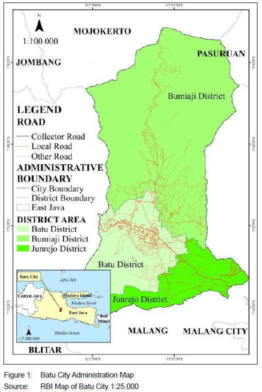
Originally part of the Malang Regency, Batu achieved autonomy as an administrative city in 2001 following the enactment of Law No. 11/2001. Covering an area of 194.17 km2, the city comprises three districts: Batu, Junrejo, and Bumiaji. Its administrative boundaries are defined as follows:
• North: Mojokerto Regency and Pasuruan Regency, and
• South, West, East: Malang Regency
The city had a population of 221,714 in 2023, with an annual growth rate of 0.27% between 2020 and 2023 (Badan Pusat Statistik, 2024: 51). Agriculture and tourism are the primary economic sectors. The agricultural industry thrives, due to the favourable mountainous terrain and cool climate, supporting the cultivation of horticultural products such as fruits, flowers, and vegetables (Fitroya, 2018: 85-86).
Tourism plays a central role in the local economy, positioning Batu City as one of the most popular destinations in East Java, attracting approximately 8.7 million visitors in 2023 (Badan Pusat Statistik, 2024: 302). The city's scenic beauty, fresh climate, and mountainous surroundings, including Mount Panderman, Mount Arjuna, and Mount Wukir, serve as key attractions.
4. METHODS
4.1 Research design
This study adopts a mixed-methods approach, combining both qualitative and quantitative research techniques (Creswell, 2021). The qualitative component involves a comprehensive document review to gather data on infrastructure development planning and its alignment with the spatial plan. The key documents analysed include the RKPD for 2017-2019 and 2022-2024, as well as the Batu City RTRW for 2010-2030. Direct observation was conducted to collect geospatial coordinates for mapping the integration between infrastructure development locations and the RTRW's primary programmes. The quantitative component follows Bethlehem's (2009) approach, employing a structured survey questionnaire to assess stakeholders' knowledge and understanding of the Batu City RTRW and its role in development programme planning. Data analysis was conducted using both inferential and decision-making methods:
• The chi-square test was applied to examine the relationship between stakeholders' understanding of the RTRW and the alignment of planned development locations with spatial objectives.
• The SWOT-AHP (Strengths, Weaknesses, Opportunities, and Threats combined with the Analytical Hierarchy Process) method was used to statistically derive strategic recommendations for enhancing stakeholder engagement and improving synchronisation between the RTRW and development planning processes.
This integrative research design provides a robust framework for understanding and improving the integration of spatial and development planning in Batu City.
4.2 Population and sample
The population in this study comprises stakeholders involved in the planning of development programmes. The research sample includes 45 stakeholders within the mandatory government affairs sector, which are governed by Law No. 23, Article 363 of 2014, concerning Regional Governments in Indonesia. This law regulates collaborative activities conducted by regional governments with other regions, third parties, and institutions or foreign regional governments, all based on considerations of efficiency and effectiveness in public services. Mandatory government affairs for the 2016-2019 and 2022-2024 periods, with infrastructure development programmes, encompass sectors such as education, health, housing and settlement, tourism, agriculture and forestry, environment, public works, and spatial planning.
Following the Minister of Home Affairs Regulation No. 5 of 2017, stakeholders are categorised according to their roles in the planning, control, and evaluation of regional development. Thus, the sample is limited to stakeholders involved in the preparation of work programme planning. Based on this criterion, the sampling design in this study employed sequential sampling with multiple techniques (Moh, 2003). In the first stage, the researcher selected a sample of 25 stakeholders involved in planning development programmes within the mandatory government affairs sector. These respondents were chosen through direct appointments by the Head of the Development Programming Division. This appointment process reflects the structural and bureaucratic nature of Indonesian Regional Government units, as defined by Government Regulation No. 18, Article 89/2016, concerning regional apparatus. As a result, stakeholders were selected based on their primary roles and responsibilities in development programme planning.
To enrich the data for analysis, the researcher expanded the sample in the second stage. This phase involved broadening the respondent pool to include staff from the development programming division. The inclusion criterion stipulated that respondents must have prior experience in preparing programme proposals or plans for the Regional Development Planning Document (RKPD) at least once. As a result, 20 additional stakeholders were included, bringing the total sample size to 45. Of the 45 distributed questionnaires, only 22 were valid for analysis, resulting in a response rate of 49% (see Table 1).

4.3 Data collection
The first data-collection method is literature review. The review involves comparing the infrastructure development location planning map, sourced from the Batu City RTRW (Spatial Plan) document for 20102030, with development programme plans obtained from the Batu City Regional Work Plan (RKPD) documents for the years 2017, 2018, 2019, 2022, 2023, and 2024.
The selection of these specific years is guided by the following considerations:
a. Pre-pandemic period: The years 2017 to 2019 represent a period of normal development activity, unaffected by the Covid-19 pandemic;
b. Pandemic impact: Development programme planning during 2020 and 2021 was largely redirected toward managing the pandemic, rendering these RKPD documents less representative of regular regional development activities;
c. Post-pandemic recovery: The years 2022 to 2024 mark a return to normal planning conditions, making them suitable for analysing development strategies under standard circumstances.
The second data-collection method is observation and field survey. Ground checking is a field activity which ensures that the coordinates on the map align with the location of land used for regional infrastructure development (Pontoh et al., 2013). The purpose of ground checking is to take the coordinates displayed on the map for mapping the integration of the location of the infrastructure development programme with the RTRW main programme. The mapping in the research uses Geography Information System (GIS) tools and the GIS software is ArcGIS 10.8.
The third data-collection method is a structured survey questionnaire. A structured survey questionnaire is a research instrument that uses a predefined list of questions to guide respondents (Sugiyono, 2017; Ramdhan, 2021). This method was employed to gather data on the mechanisms for preparing development programmes by the Regional Apparatus Organisation (OPD) stakeholders involved in the research.
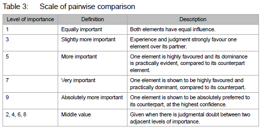
The questionnaire comprised three questions designed to evaluate respondents' knowledge, understanding, and utilisation of the Batu City Spatial Plan (RTRW) in the development programme planning process. It consisted of closed-ended questions with tick-box response options. Respondents were first required to select either "Yes" or "No" based on their circumstances. Following this, they could choose from a set of predefined options to indicate their reasons for selecting either "Yes" or "No". The AHP questionnaire presented elements within the four SWOT components as closed-ended questions. Respondents were instructed to rate these elements on a 1-9 scale, where 1 represented "equally important" and 9 indicated "extremely important", based on their perceived importance in the preparation of development programme plans in Batu City.
4.4 Data-analysis method
Using Statistical Product and Service Solutions (SPSS), the data-analysis method in this research includes descriptive spatial analysis, AHP SWOT, and chi-square test (Rismen, Lovia & Ramadoni, 2023).
Descriptive spatial analysis is a method that uses statistical methods and GIS to identify spatial patterns and trends from data. It examines spatial positions and objects in relation to the phenomena being studied (Irwansyah, 2013). This approach is used to analyse the integration of infrastructure development planning locations for the 2017-2019 and 2022-2024 periods with the Regional Spatial Planning (RTRW) document. In this study, descriptive spatial methods were chosen, due to the availability of three types of spatial data: points, lines, and polygons. However, only point data, representing the locations of proposed infrastructure development, were available in the RKPD (Regional Government Work Plan). The line data, on the other hand, were derived from the spatial plan map of the main programmes documented in the RTRW. This method was selected because the proposed infrastructure location map was not available for the analysis period of this study. The spatial analysis procedure consists of five steps:
1. Location analysis: The locations of infrastructure development plans in the RKPD document were identified. This allowed for the extraction of point and line (vector) data, which were subsequently used to create maps.
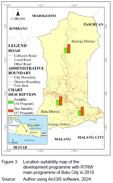
2. Compatibility assessment: The infrastructure development locations from Step 1 were compared with the main programme locations outlined in the RTRW 2010-2030 document. This comparison involved checking the alignment of land use with the spatial pattern specified in the RTRW. The results of this compatibility check are presented in Table 2. A location is considered compatible if the infrastructure development in the RKPD aligns with a corresponding main programme in the RTRW and if both the programme and location coincide. In contrast, the location is deemed incompatible if the infrastructure development is part of the RTRW main programme but does not match the spatial location. Similarly, if the infrastructure programme is not part of the RTRW main programme, it is also deemed incompatible.
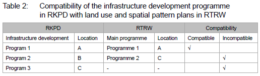
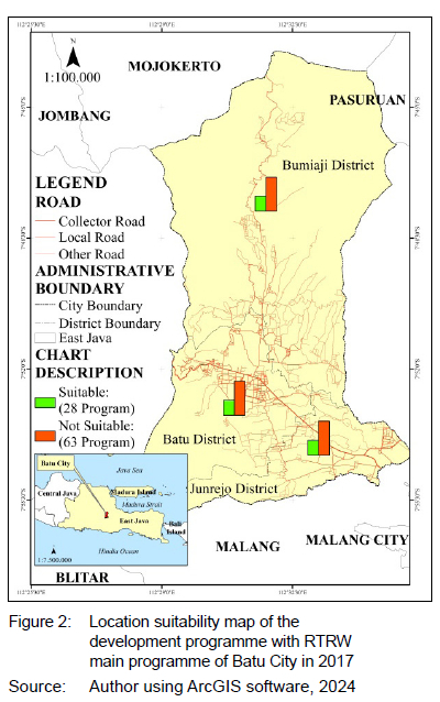
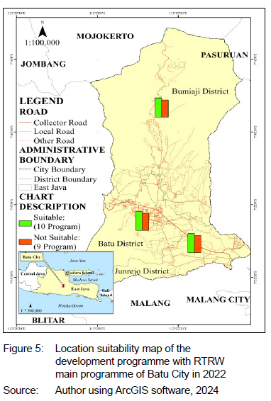
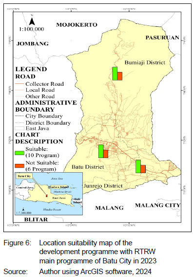
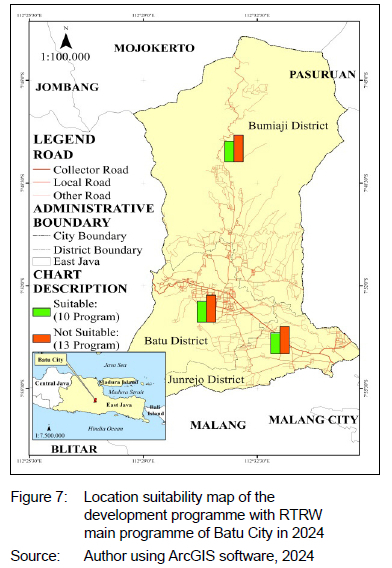
3. Suitability mapping: Based on the results of the compatibility analysis, suitability maps were created. These maps were generated at a 1:25,000 scale, using ArcGIS software.
4. Map layout: The final maps were enhanced with the addition of map boundaries, grids, legends, orientation markers, and scale bars to improve the clarity and readability of the data visualisation.
5. Final map: A map displaying the suitability of the infrastructure development programme plan for Batu City during the 20172019 and 2022-2024 periods was produced (see Figures 2 to 7).

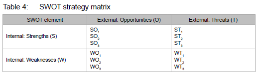
The SWOT-AHP method combines the Strengths, Weaknesses, Opportunities, and Threats (SWOT) analysis with the Analytical Hierarchy Process (AHP), creating a robust decision-making framework known as SWOT-AHP (Saaty & Islam, 2015). This integrated approach leverages the SWOT framework to identify key factors affecting a decision, while employing the AHP methodology to assign relative weights to these factors, thereby supporting the formulation of strategic decisions (Saaty & Islam, 2015). The SWOT-AHP process largely follows the conventional AHP approach but is enriched by the inclusion of SWOT analysis elements. The process begins with the decomposition of the decision problem into relevant criteria and sub-criteria, establishing a hierarchical structure (Saaty & Islam, 2015). Pairwise comparisons are then conducted between these elements, and the resulting judgments are synthesised to identify alternative strategies based on priority rankings (Saaty & Islam, 2015). In this study, the Batu City Government is faced with assessing internal and external environmental factors that influence the implementation of the city's spatial planning (RTRW) development programme.
The SWOT-AHP analysis is executed in two distinct stages. In the first stage, the SWOT method is employed to identify factors of strengths, weaknesses, opportunities, and threats that influence strategies aimed at enhancing the implementation of the RTRW development programme. The second stage involves applying the AHP to the identified SWOT factors. In this stage, each factor is weighted, or scored, to determine its relative importance, thus guiding the selection of strategies to improve RTRW implementation. Although the overall process follows the conventional AHP framework, certain modifications are made to suit the SWOT-AHP approach. Specifically, the goal of the analysis is to prioritise strategies for enhancing RTRW implementation, while the factors and alternatives are derived from the earlier SWOT analysis. The weighting of these elements is performed, using Saaty's scale of pairwise comparison (Saaty & Islam, 2015). The data used for SWOT-AHP analysis include the importance levels of various criteria and factors.
Once the AHP analysis is conducted, the weights for each SWOT component are determined. These weighted values are then used to link the SWOT elements and develop strategic options. These strategies are categorised as follows:
• SO (Strengths-Opportunities): Leveraging strengths to capitalise on opportunities.
• ST (Strengths-Threats): Utilising strengths to mitigate threats.
• WO (Weaknesses-Opportunities): Addressing weaknesses while exploiting opportunities.
• WT (Weaknesses-Threats): Reducing weaknesses to combat threats.
The strategic priorities are derived by aggregating the weights of the SWOT components linked to each strategic direction (Kahraman, 2008). These total weights are ranked, with the highest-ranked strategy reflecting the most prioritised course of action for enhancing RTRW implementation in Batu City's development agenda. The SWOT-AHP methodology in this study uses Saaty's 9-point scale for pairwise comparison of criteria. The scale provides a standardised way of assessing the relative importance of one factor over another:
These comparisons are made between the elements within the SWOT matrix, and the relative importance is assigned to each based on expert judgment.
The strategy matrix generated from the SWOT-AHP analysis categorises strategies based on the intersection of internal (strengths and weaknesses) and external (opportunities and threats) factors. The matrix helps visualise the various strategic options available, as shown in Table 4.
To complement the SWOT-AHP analysis, a chi-square test (Turhan, 2020) is used to examine the relationship between stakeholders' understanding and knowledge of the RTRW development programme and the locations where the development is planned. Chi-square test correlations between non-numeric variables and the distribution of categorical responses across groups is appropriate, given that the data on understanding and knowledge are ordinal in nature. A significance level of 5% is employed, meaning that a p-value of less than 0.05 indicates a significant relationship between stakeholder knowledge and the location of development programmes, while a p-value greater than or equal to 0.05 suggests no significant relationship.
5. RESULTS AND DISCUSSION
5.1 The integration of infrastructure development programmes between RTRW and RKPD (2017-2019, 20222024) in Batu City
The assessment comprised two components, namely strategic and tactical. The strategic assessment focused on programmatic alignment, evaluating compliance with zoning regulations, land-use patterns, and the city's macro-spatial objectives. This component examined whether the objectives, strategies, and activities outlined in the Annual Development Programmes such as local government work plans aligned with the spatial structure and patterns defined in the Regional Spatial Plan (RTRW). In contrast, the tactical assessment was site-specific and pragmatic, concentrating on the physical location of projects to ensure their legal compliance and contextual suitability.
5.1.1 Strategic: Alignment of annual development programmes with spatial pattern plan indications in the RTRW
This study assesses the conformity between the infrastructure development locations listed in the Batu City Regional Work Plan (RKPD) for 2017-2019 and 20222024 and the indications of the Spatial Pattern Realisation Plan in the RTRW (2010-2030). The RTRW provides guidance on spatial utilisation by specifying proposed development programmes, locations, timelines, budgets, funding sources, and implementing agencies.
The RTRW divides the spatial development timeline into four phases over 20 years:
• Phase I (2010-2015)
• Phase II (2016-2020)
• Phase III (2021-2025)
• Phase IV (2026-2030)
This study focuses on infrastructure development during Phase II (20162020) and Phase III (2021-2025).
Table 5 summarises the distribution of infrastructure development programmes based on government affairs over the selected years:
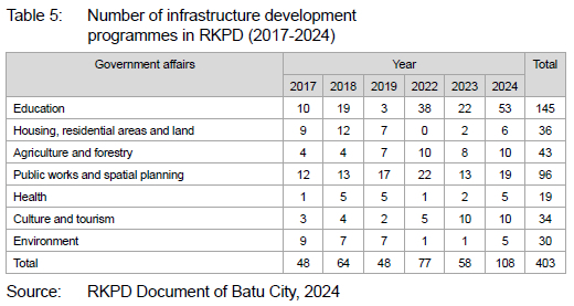
The data show an average of 67 infrastructure development programmes per year for 2017, 2018,2019, 2022, 2023, and 2024. These programmes support the realisation of the spatial structure outlined in the RTRW.
Batu City's economy relies heavily on agriculture and tourism, supported by green infrastructure such as forests, plantations, and agricultural zones. Government efforts increasingly integrate tourism and agriculture, converting some agricultural areas into agrotourism destinations. Infrastructure development to support tourism activities has largely centred on physical improvements such as road networks, park benches, photography spots, and sanitation facilities. However, non-infrastructure initiatives such as management scheme development, service quality improvement, and community empowerment have received limited attention.
Spatial use planning in the RTRW specifies key development programmes and their locations. The research identified six development programmes that aligned with RTRW indications:
1. Road and bridge improvement programmes along Batu-Selecta, Songgoriti-Pandesari, Sultan Agung, and Tulungrejo-Sumbergondo corridors.
2. Construction of roads and bridges in the Dau-Pendem-Junrejo-Tlekung-Oro-Oro Ombo-Pesanggrahan section.
3. Development of primary and secondary irrigation canals.
4. Creation of city parks, including the Lippo Mall area in Temas Village.
5. Forest rehabilitation around springs.
6. Housing development in Oro-Oro Ombo and Tlekung Villages.
Additional development programmes from 2022 to 2024 included road festivals, riverbank preservation, historical building conservation, and agrotourism village planning.
The development of formal housing, overseen by public works and spatial planning, aligns with spatial designations outlined in the RTRW document, particularly in Oro-Oro Ombo (Batu District) and Tlekung (Junrejo District). These formal settlements, planned and recognised by the government, provide managed housing infrastructure (UNHCR, 2015). The strategic location of these sub-districts supports city centre functions: Batu District serves as the administrative, commercial, and tourism hub, while Junrejo supports urban settlements, health services, higher education, and office functions.
Notable residential developments in Batu District include Mutiara Residence, Kusuma Estate Baru, and Villa Kusuma Agro. Junrejo hosts Kayana Regency, Emerald Villas, and Grand Mandiri Land Housing. However, these developments, driven by private property entrepreneurs, often extend beyond the RTRW infrastructure guidelines, with housing projects frequently encroaching on productive agricultural land through land purchases and permits issued by local authorities - a long-standing phenomenon in Indonesia.
Land-use changes in Junrejo and Batu Districts illustrate significant transformations between 2006 and 2023. Built-up land expanded by 5.2% (1,035.8 ha), while forested areas decreased by 5% (1,005.1 ha) and paddy flelds shrank by 0.5% (94 ha). This shift is largely attributed to deforestation and land conversion for residential and tourism purposes. Empirical assessments (Yudichandra Widiatmaka & Anwar, 2020) found that 52.63% of land transitioned from non-built to built-up categories. In Junrejo alone, residential land grew by 3.93% between 2014 and 2023, increasing from 489.86 ha to 588.57 ha. Concurrently, paddy flelds declined by 72.44%, dropping from 2,399.98 ha in 2016 to 1,738.56 ha by 2023. This rapid conversion reflects the transformatior of rice fields into residential areas, commercial properties, and tourism infrastructure, reshaping land-use patterns in the region.
The planned infrastructure development location for education and health in Batu City does not align with the RTRW document. Both sectors have focused solely on maintaining existing facilities rather than constructing new ones, limiting the capacity to fully meet residents' needs. Consequently, the RKPD primarily emphasises improvements rather than expansion in health and education infrastructure.
Infrastructure development plays a key role in enhancing residents' quality of life (Hadiwijoyo & Anisa, 2019), often measured by the Human Development Index (HDI). The HDI encompasses health (Life Expectancy/AHH), education (Literacy Rate/AMH), and living standards. Table 6 shows that from 2017 to 2023, Batu City's average life expectancy (AHH) was 73.33 years, surpassing East Java's 71.36. Meanwhile, the literacy rate (AMH) averaged 9.154 years of schooling, notably higher than the provincial figure of 7.692, indicating progress in education.
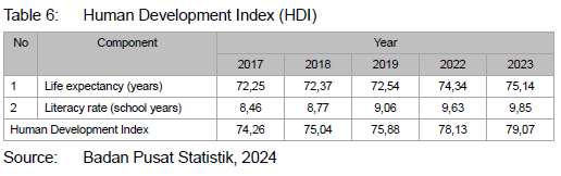
The HDI score for Batu City rose steadily from 74.26 in 2017 to 79.07 in 2023, averaging 76.48 over the period. This improvement reflects advancements in health, education, and quality of life, supported by adequate healthcare services and educational initiatives. However, infrastructure development remains largely tourism-oriented, exemplified by the new Among Tani Main Market, which began operations in 2023 (Febrianto, 2024). Physical infrastructure investment in non-tourism sectors continues to lag, highlighting a need for greater alignment with RTRW goals to support sustainable urban development.
5.1.2 Tactical: Compatibility of infrastructure development locations between annual development planning and spatial planning documents in Batu City
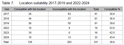
Figures 2 to 7 and Table 7 illustrate the integration of infrastructure development locations with the Batu City Spatial Plan (RTRW) for the periods 2017-2019 and 2022-2024. Analysis of location suitability reveals that only 38.6% of infrastructure development programmes were compatible with spatial designations in the RTRW between 2017 and 2024. Out of 331 identified development programmes, 128 were aligned with the RTRW, while 203 were not, showing that 61.4% of infrastructure development programmes were not compatible with spatial designations in the RTRW. This significant gap shows the lack of synergy between spatial planning (RTRW) and annual development planning (RKPD).
The misalignment highlights several factors. Rapid transitions from agricultural to non-agricultural land use and the emergence of tourism activities demand ongoing revisions to spatial planning. Informal planning processes appear to remain more dominant than formal planning mechanisms, even though formal stakeholders demonstrate a high level of understanding of spatial planning policies. According to survey results (Table 9), 82% of stakeholders reported strong familiarity with RTRW regulations.

Despite the noted deficiencies, Table 8 shows that development programmes for seven mandatory government sectors exhibit a high level of compatibility with the RTRW, achieving a conformity rate of 95.61%. Sectors such as education, environmental affairs, and public works achieved full compliance, while other sectors, including housing and tourism, also demonstrated high compatibility levels.
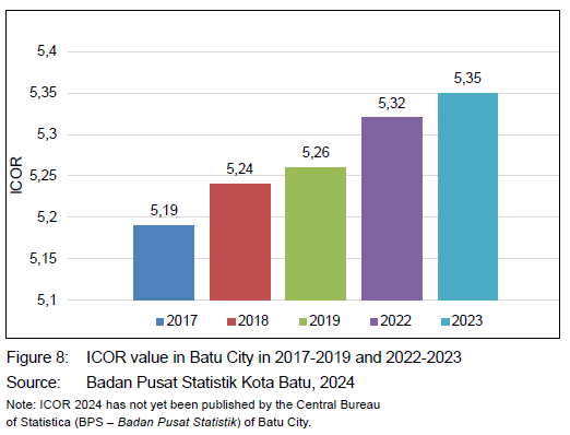
The suitability of the location of infrastructure development in the RTW with the development programme in the RKPD is supported by investment that tends to increase. This is evident from the Incremental Capital Output Ratio (ICOR) value in 2017-2019 and 2022-2023. The ICOR value is a macroeconomic parameter that describes the ratio of capital investment to the results obtained (output) using investment. A rising ICOR suggests lower investment efficiency, meaning more capital is required to generate additional output. This trend could indicate higher costs of investment or diminishing returns on infrastructure projects.
This trend also indicates that relatively stable infrastructure development is an attraction for investors to invest. The focus of investment is in the tourism sector and its supporters (trade, hotels, restaurants), which means that external factors such as tourism demand, economic stability and security of Indonesia are factors that affect ICOR. ICOR shows a positive value and increases by 0.16 during the analysis year (Figure 8).
The high compatibility rate for these mandatory sectors indicates that stakeholders have generally referred to RTRW guidelines when formulating development programmes. This suggests an effective utilisation of spatial planning, particularly through the integration of RTRW with RKPD, the city's annual development planning document coordinated by the Batu City Development Planning and Research Agency. This alignment confirms the importance of formal spatial planning as a guiding tool for infrastructure development, although continuous improvements are needed to address the relatively weak coordination between technical services such as agriculture and health.
5.2 Stakeholder knowledge and practice of using spatial planning documents (RTRW) in determining the location of infrastructure development programmes
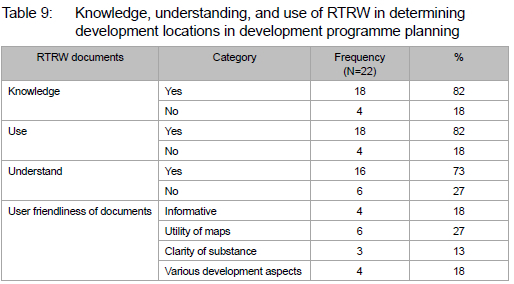
The utilisation ofthe Regional Spatial Planning Document (RTRW) in development programme planning was assessed based on stakeholder knowledge, understanding,and application of the document regarding development locations. This assessment is contextualised by comparing the number of programmes that incorporated RTRW guidelines with those that did not The extent of RTRW involvement serves as an indicator of stakeholder awareness and commitment to sustainable development. Table 9 presents the percentages of knowledge, understanding, and usage of RTRW among stakeholders:
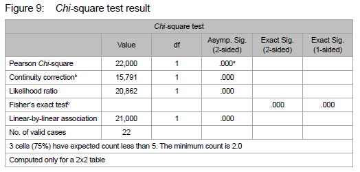
The findings in Table 9 reveal that 82% of stakeholders demonstrated both knowledge and application of RTRW in preparing location development programmes,while 73% exhibited a clear understanding of RTRW. In addition 18% had knowledge of RTRW but did not apply it, and 27% lacked comprehension altogether. The Chi-square test yields a p-value of 0.000, which is smaller than the significance level of 0.05, indicating a strong, significant relationship between stakeholder understanding and knowledge of the RTRW in infrastructure development planning. This relationshipis attributed to factors such as the informative nature of the RTRW (18%), the usefulness of maps for understanding locations (27%), the clarity of its substance (13%), and its comprehensive attention to development aspects (18%). Despite this, 22.5% of stakeholders still reported challenges in understanding the RTRW material.
This finding can be theoretically explained using Andragogy Theory, which defines adult learning and self-directed responsibility in decisionmaking (Knowles, 1979: 45-47). In this context, adult stakeholders in Batu City, who are expected to take responsibility for decisions within development planning, are mainly able to solve problems and navigate challenges related to the RTRW, as they possess the maturity required for critical decision-making (Sudjana, 2005). The application of RTRW in planning infrastructure programmes aligns with the principles of Andragogy, which highlight the importance of understanding spatial planning for informed decision-making in the context of infrastructure development.
Stakeholders involved in preparing development programmes highlighted the importance of referring to the RTRW. This finding is supported by evidence that stakeholders were actively engaged in discussions during the RTRW document drafting process organised by the Regional Development Planning Agency (Bappeda) and the Research and Development Agency (Litbang) of Batu City. Despite this involvement, 86% of stakeholders from agencies outside Bappeda Litbang did not consistently use the RTRW in their planning activities. The use of the RTRW by stakeholders in development planning is influenced by their knowledge of its existence and content. Table 10 summarises how stakeholders in Batu City access spatial planning information and their use of the Regional Spatial Planning Document (RTRW) in preparing development programme plans (RKPD).
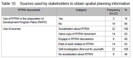
Stakeholders obtained information about spatial planning primarily through socialisation sessions about the RTRW organised by Bappeda Litbang (100%) and self-investigation (100%). In addition, 63% of stakeholders reported owning a copy of the RTRW document and having job roles related to it, whereas 40% engaged in discussions about the RTRW and reported receiving no socialisation. However, a critical observation is that good knowledge of spatial planning does not always translate into its effective application. The implementation of development planning is influenced by multiple factors, including external and internal environments, human resources, systems and policies, scientific knowledge, and funding availability (Riyadi & Baratakusumah, 2004).
Spatial planning in Indonesia follows Government Regulation No. 21, Article 23, paragraph (2) of 2021 concerning the implementation of spatial planning. The process includes several stages: preparation of a framework and methodology; data collection (administrative, population, land sector, disaster, and map data); data processing and analysis (regional potential and environmental carrying capacity); formulation of the spatial planning concept, and drafting spatial planning regulations.
Despite this structured approach, the RTRW often remains underutilised. Without active usage, the RTRW remains largely ineffective as a tool for regional development guidance. This issue is not unique to Batu City. It reflects a broader trend across Indonesia's autonomous regions. For example, Sumedang Regency experienced deviations from the 2011-2031 RTRW, with paddy fields and other land types being repurposed, leading to significant changes in land use (Khaerani, Sitorus & Rusdian, 2018). West Aceh Regency similarly encountered deviations, with protected forests being converted to production and plantation areas.
Challenges in spatial planning are not exclusive to Indonesia. In Nigeria, for instance, the city of Jos has faced a mismatch between spatial plans and actual development outcomes, largely due to political, cultural, institutional, and legal constraints (Gupta, 2001; Obateru, 2004). Rapid urban expansion, slum settlements, and environmental degradation are common consequences in developing countries such as India and Nigeria (Oyesiku, 2004; Jiriko, 2008). These nations have many urban-biased policies, influenced by proximity to government centres and the rapid growth of urban areas (Lipton, 1977).
In contrast, developed countries such as Scotland have made significant strides in integrated spatial planning (Larsson, 2006). Scotland's approach emphasises the integration of spatial planning with other policy sectors to coordinate land use and infrastructure provision effectively. This example shows the potential for comprehensive spatial planning strategies to address land-use challenges more systematically in Batu City and beyond.
5.3 Strategy to increase the synchronisation of regional spatial planning with the development programme of Batu City
Effective spatial planning requires synchronisation with development programmes, in order to support sustainable regional growth. When these elements are not integrated, an implementation strategy becomes essential. This section presents the analysis derived from a stakeholder survey, evaluated using the SWOT-AHP (Strengths, Weaknesses, Opportunities, and Threats - Analytic Hierarchy Process) method. The findings are summarised in Tables 11-14.
Strategie directions for enhanced synchronisation of RTRW utilisation in preparing development programme planning include:
SO1: Form a specialised task force comprising professionals with expertise in spatial planning (RTRW) and regional development (RKPD). This team should facilitate integrated and evidence-based planning processes to enhance development synchronisation.
ST1: Ensure sustained government engagement and adherence to RTRW principles, supporting a planning environment conducive to improved quality of life for Batu City residents.
WO1: Develop a dynamic RTRW framework that responds to evolving societal and environmental conditions that incorporates inclusive community participation mechanisms.
SO2: Maintain the city government's commitment to spatial planning implementation while institutionalising opportunities for RTRW revisions every five years to accommodate changes in development needs.
WT1: Implement strict sanctions to address misalignment between development programmes and RTRW directives, recognising the adverse impacts of such discrepancies on environmental sustainability.
WT2: Develop synergistic policy frameworks that align RTRW implementation with development programmes, thereby minimising environmental degradation.
ST2: Provide detailed and actionable RTRW materials to guide the development of programmes aligned with spatial planning objectives, thereby boosting community productivity.
WO2: Institutionalise RTRW as a fundamental criterion for development programme approval. In addition, enact legal frameworks mandating compliance with spatial planning directives to ensure sustainable development outcomes.
6. CONCLUSION
The integration between Batu City's spatial planning document (RTRW) and its annual development programme plan (RKPD) remains weak, with an integration level of only 38.67%. This disconnect stems from three primary factors:
1. Differences in knowledge and understanding regarding the spatial priorities for infrastructure development outlined in the RTRW compared to the RKPD.
2. The RTRW is often treated as a formal document created solely to meet the administrative requirements stipulated by the Ministry of Home Affairs Regulation No. 86/2017, rather than as a strategic planning tool.
3. Temporal misalignment, where the RTRW covers a 20-year planning horizon, while the RKPD is prepared annually as part of the budget submission process.
This limited integration has already contributed to environmental challenges and undermines efforts toward sustainable development. Given Indonesia's regulatory framework, including Presidential Regulation No. 111/2022 and the Ministry of National Development Planning Regulation No. 7/2018, local governments are mandated to align development efforts with the SDGs. Batu City has adopted the integration of development and environmental sustainability as a key strategy to achieve the SDGs. Its long-term development targets (RPJPD) for 2025-2045 emphasise a more inclusive and environmentally responsible approach to sustainable development. For example, the Batu City government has implemented several strategies. One key initiative is protected agricultural land (LSD) mapping across seven villages, namely Dadaprejo, Torongrejo, Pendem, Mojorejo, Junrejo, Beji, and Temas, to monitor and safeguard agricultural land.
The city is also working to align its spatial planning with its regional vision: "Civil Batu City: Sustainable, Agro-Creative, Integrated, Superior, Synergistic, Accommodating, and Ecological Towards the Golden Generation 2045". This vision is being integrated into the formulation of the Regional Medium-Term Development Plan (RPJMD) 2025-2030, ensuring that spatial planning efforts contribute to long-term economic and environmental sustainability.
However, weak coordination between technical services as implementers of development and stakeholders who realise planning documents, risks hindering these objectives.
To address these challenges, Batu City must adopt a more progressive and coordinated strategy. A crucial first step is the establishment of a task force responsible for harmonising the RTRW and RKPD, ensuring that annual development programmes align with long-term spatial objectives. Equally important, the Batu City government must support a strong, collaborative commitment among all Regional Apparatus Organisations (OPD) involved in the development planning process to facilitate the successful integration of the RTRW and RKPD.
By taking these steps, Batu City can move toward a more integrated and sustainable development framework, aligning local development goals with national regulations and environmental sustainability targets.
REFERENCES
ADEBAYO, T.S., AKADIRI, S., ASUZU, C. & HAMISU, N. 2023. Impact of tourist arrivals on environmental quality: A way towards environmental sustainability targets. Current Issues in Tourism, 26(6), pp. 958-976. https://doi.org/10.1080/13683500.2022.2045914 [ Links ]
AMRULLAH, K. 2024. Musrenbang Kecamatan Junrejo Kota Batu, Berikut Ini Usulan yang Ditampung demi Pembangunan. Radar Batu. [Online]. Available at: <https://radarbatu.jawapos.com/kota-batu/2324386301/musrenbang-kecamatan-junrejo-kota-batu-berikut-ini-usulan-yang-ditampung-demi-pembangunan> [Accessed: 23 May 2024]. [ Links ]
ARDIANSYAH, F. 2023. Hingga April, 77 Bencana Alam Terjadi di Kota Batu. Radio Republik Indonesia, 5 April. [Online]. Available at: <https://www.rri.co.id/malang/daerah/205404/hingga-april-77-bencana-alam-terjadi-di-kota-batu> [Accessed: 23 May 2024]. [ Links ]
BADAN PUSAT STATISTIK. 2006. Kota Batu Dalam Angka. Kota Batu: Badan Pusat Statistik Kota Batu. [ Links ]
BADAN PUSAT STATISTIK. 2022. Kota Batu Dalam Angka. Kota Batu: Badan Pusat Statistik Kota Batu. [ Links ]
BADAN PUSAT STATISTIK. 2024. Kota Batu Dalam Angka. Kota Batu: Badan Pusat Statistik Kota Batu. [ Links ]
BADAN PUSAT STATISTIK KOTA BATU. 2024. Human Development Index (HDI) of Batu Municipality. [Online]. Available at: <https://batukota.bps.go.id/en/statistics-table/2/ODEjMg==/human-development-index-hdi-of-batu-municipality.html> [Accessed: 1 February 2025]. [ Links ]
BETHLEHEM, J. 2009. Applied survey methods: A statistical perspective. Hoboken, NJ: John Wiley & Sons. https://doi.org/10.1002/9780470494998 [ Links ]
BROCKETT, C.D. 2019. Land, power, and poverty: Agrarian transformation and political conflict in Central America. London: Routledge. https://doi.org/10.4324/9780429034060 [ Links ]
BRUVO, J. & JAKOVCIC, M. 2019. Strategic city projects as a strategic planning tool: An overview of terms and models. Hrvatski geografski glasnik/ Croatian Geographical Bulletin, 81, pp. 5-29. https://doi.org/10.21861/HGG.2019.81.01.01 [ Links ]
CAHYANI, D.T., MUNIBAH, K. & MULYANTO, B. 2019. Spatial utilization control for supporting development acceleration: Case study in South Tangerang City, Banten Indonesia. IOP Conference Series: Earth and Environmental Science, 393(1), p. 12070. https://doi.org/10.1088/1755-1315/393/1/012070 [ Links ]
CRESWELL, J.W. 2021. A concise introduction to mixed methods research. Thousand Oaks, CA: Sage Publications. [ Links ]
DINAS PERTANIAN. 2024. Laporan Kinerja Instansi Pemerintah (LKjIP) Dinas Pertanian Kota Batu Tahun Anggaran 2024. Batu. [ Links ]
FARIDA, I. 2024. Pembangunan tata ruang di indonesia: Tantangan dan harapan. Jurnal Ilmiah Galuh Justisi, 12(1), pp. 88-99. https://doi.org/10.25157/justisi.v12i1.13040 [ Links ]
FEBRIANTO, V. 2024. Ikon wisata baru Kota Batu itu adalah Pasar Induk Among Tani. ANTARA, 31 January. [Online]. Available at: <https://www.antaranews.com/berita/3941046/ikon-wisata-baru-kota-batu-itu-adalah-pasar-induk-among-tani> [23 May 2024] [ Links ]
FITROYA, N.H. 2018. Evaluas! Strategi Pengembangan Pertanian Organik Di Kota Batu (Studi Pada Dinas Pertanian Dan Kehutanan Kota Batu). Universitas Brawijaya. DOI: SKR/ FIA/2018/88/051802246 [ Links ]
GRIGG, N.S. 2010. Infrastructure finance: The business of infrastructure for a sustainable future (Vol. 536). Hoboken, NJ: John Wiley & Sons. https://doi.org/10.1002/9781118266182 [ Links ]
GUPTA, D.K. 2001. Public policy analysis. Concepts, tools and techniques. Washington, D.C.: Congressional Quarterly. [ Links ]
HADIWIJOYO, S.S. & ANISA, F.D. 2019. Perencanaan Pembangunan Daerah. Suatu Pengantar. Depok: Rajawali Pers. [ Links ]
HADIWIJOYO, S.S. & ANISA, F.D. 2020. Perencanaan pembangunan daerah berbasis SDGs. Depok: Rajawali Pers. [ Links ]
HASTUTI, E. 2011. Kajian Perencanaan Ruang Terbuka Hijau (RTH) perumahan sebagai bahan revisi SNI 03-1733-2004. Jurnal Standarisasi, 13(1), pp. 35-44. [ Links ]
IRWANSYAH, R. 2013. Sistem informasi geografis: prinsip dasar dan pengembangan aplikasi. Yogyakarta: Digibooks. [ Links ]
JIRIKO, K. 2008. Urban Master Planning Paradigm in Nigeria: What future? Kaduna: Mba Prints+ Graphics. [ Links ]
JUWITA, M.R., SUPRIYADI, A., XINYANG, J. & WANG, T. 2021. The challenges of spatial planning in Indonesia under the background of local autonomy. World Regional Studies, 30(1), pp. 48-56. DOI: 10.3969/j.issn.1004-9479.2021.01.2019357 [ Links ]
KAHRAMAN, C. 2008. Multi-criteria decision making methods and fuzzy sets. Boston: Springer. https://doi.org/10.1007/978-0-387-76813-7_1 [ Links ]
KHAERANI, R., SITORUS, S. & RUSDIANA, O. 2018. Analisis Penyimpangan Penggunaan Lahan Berdasrakan Rencana Tata Ruang Wilayah Kabupaten Sumedang. Tataloka, 20(4), pp. 399-409. https://doi.org/10.14710/tataloka.20.4.399-409 [ Links ]
KNOWLES, M. 1979. The adult learning. 3rd edition. Houston: Gulf Publishing. [ Links ]
KUSRIYAH, S. 2023. The implementation of spatial planning policy through spatial utilization to realize sustainable regional spatial order. Journal of Governance and Regulation, 12(4 Special Issue), pp. 277-286. https://doi.org/10.22495/jgrv12i4siart7 [ Links ]
KUSRIYAH, S. & WITASARI, A. 2024. Sosialisasi kebijakan penataan ruang melalui pemanfaatan ruang untuk pembangunan yang berkelanjutan. Jurnal Penelitian Dan Pengabdian Kepada Masyarakat UNSIQ, 11(1), pp. 16-24. https://doi.org/10.32699/ppkm.v11i01.5680 [ Links ]
LARSSON, G. 2006. Spatial planning systems in Western Europe: An overview. Amsterdam, Netherlands: IOS Press. [ Links ]
LIPTON, M. 1977. Why poor stay poor: A study of urban bias in world development. London: Maurice Temple Smith Ltd. https://doi.org/10.5771/0506-7286-1978-4-462 [ Links ]
LIU, Y. & ZHOU, Y. 2021. Territory spatial planning and national governance system in China. Land Use Policy, 102, article 105288. https://doi.org/10.1016/j.landusepol.2021.105288 [ Links ]
MATTERNICHT, G. 2017. Land use planning. Working paper. Germany, Bonn: United Nations Convention to Combat Desertification. [ Links ]
MOH, N. 2003. Metode Penelitian. Jakarta: Ghalia Indonesia. [ Links ]
NURLAMBANG, T. 2020. Geographic and institution matters in achieving sustainable development in Indonesia. In: Bański, J. (Ed.). Dilemmas of regional and local development. London: Routledge, pp. 72-85. https://doi.org/10.4324/9780429433863-6 [ Links ]
OBATERU, O. 2004. Planning and administration. In: Tunde, O. et al. Readings in urban and regional planning. Ibadan, Nigeria: Macmillan, pp. 325-375. [ Links ]
ODENDAAL, N. & MCCANN, A. 2016. Spatial planning in the Global South: Reflections on the Cape Town Spatial Development Framework. International Development Planning Review, 38, pp. 405-423. https://doi.org/10.3828/idpr.2016.23 [ Links ]
OYESIKU, O.K. 2004. Town and country planning law and administration in Nigeria. In: Tunde, O. et al. Readings in urban and regional planning. Ibadan, Nigeria: Macmillan, pp. 257-269. [ Links ]
PEMERINTAH INDONESIA. 2014. Undang-undang (UU) Nomor 23 Tahun 2014 tentang Pemerintahan Daerah. Jakarta: Pemerintah Indonesia. [Online]. Available at: <https://peraturan.bpk.go.id/Details/38685/uu-no-23-tahun-2014> [Accessed: 23 May 2024]. [ Links ]
PEMERINTAH KOTA BATU. 2011. Peraturan daerah kota batu nomor 7 tahun 2011 tentang rencana tata ruang wilayah kota batu tahuN 2010-2030. Kota Batu: Pemerintah Kota Batu. [Online]. Available at: <http://103.211.82.11/daftar_informasi/detail/rencana-tata-ruang-wilayah-rtrw-kota-batu-tahun-2010-2030_tahun-2011_badan-perencanaan-pembangunan-penelitian-dan-pengembangan-daerah> [Accessed: 23 May 2024]. [ Links ]
PERMANA PUTRA, R., NURUL HIDAYATI, A. & SOEWAMI, I. 2021. Strategi Pembangunan Perkotaan Berkelanjutan di Kota Batu. Jurnal Inovasi Penelitian, 1(9), pp. 1-20. [ Links ]
PONTOH, N., HUDALAH, D., INDRADJATI, P. & VIANTARI, D. 2013. Dasar-Dasar Survei untuk Perencanaan Wilayah dan Kota. Bandung: Penerbit ITB. [ Links ]
RAMDHAN, M. 2021. Metode penelitian. Surabaya: Cipta Media Nusantara. [ Links ]
RIAWAN, W. 2022. Sinkronisasi Program Pemanfaatan Ruang (SPPR) Kota Tanjungpinang Dalam Mendukung Penyusunan Prioritas Program Pembangunan Daerah. Jurnal Pelita Kota, 3(1), pp. 136-149. https://doi.org/10.51742/pelita.v3i1.510 [ Links ]
RIFANI, A. et al. 2020. Development strategies of the agropolitan area in Cilacap Regency. IOP Conference Series: Earth and Environmental Science, 451(1), article 12021. https://doi.org/10.1088/1755-1315/451/1/012021 [ Links ]
RISMEN, S., LOVIA, L. & RAMADON, R. 2023. Pelatihan Pengolahan Data Menggunakan Software SPSS. ADMA: Jurnal Pengabdian dan Pemberdayaan Masyarakat, 3(2), pp. 357-364. https://doi.org/10.30812/adma.v3i2.2259 [ Links ]
RIYADI, R. & BARATAKUSUMAH, D. 2004. Perencanaan Pembangunan Daerah: Strategi Menggali Potensi Dalam Mewujudkan Otonomi Daerah. Jakarta: Gramedia Pustaka Utama. [ Links ]
RUSTAN, I.R. NAWAWI, J., NARA, N. & ABDULLAH, T. 2022. Regional medium-term development planning based on regional development from top-down approach. Journal of Positive School Psychology, 6(6), pp. 3327-3338. [ Links ]
SAATY, T.L. & ISLAM, R. 2015. Hierarchon Vol. 2: A dictionary of AHP hierarchies. Pittsburgh: RWS Publications. [ Links ]
SENTANU, I., PRABOWO, A., KUMALASARI, K., GALIH, A. & WISMANU, R. 2021. Stakeholder collaboration model for ecotourism development in Indonesia: Case study from Batu City East Java Province. Journal of Government and Civil Society, 5(2), pp. 214-236. https://doi.org/10.31000/jgcs.v5i2.4420 [ Links ]
SUDJANA, H. 2005. Strategi Pembelajaran. Bandung: Falah Production. [ Links ]
SUGIYONO, P. 2017. Metode Peneliian. Kuantitatif, Kualitatif, Dan R&D. Bandung: ALFABETA. [ Links ]
SUHARTINI, N. & JONES, P. 2023. Urbanization and the development of the Kampung in Indonesia. In: Beyond the Informal. The Urban Book Series. Springer, Cham. pp. 57-77. https://doi.org/10.1007/978-3-031-22239-9_4 [ Links ]
SUSILO, R., DHARMAWAN, A. & KURNIAWAN, F. 2021. Accept or against the change: The adaptation of the lor brantas society towards the development of Batu City. Folia Geographica, 63(1), pp. 143-165. [ Links ]
TITISARI, E., WAHID, J., ASIKIN, J. & HERLINDAH, H. & DEWI, H. 2024. Community development strategy through identification of tangible and intangible assets for the development of Baran Buring tourism Kampung. Indonesian Journal of Urban and Environmental Technology, 7(2), pp. 119-133. https://doi.org/10.25105/urbanenvirotech.v7i2.18067 [ Links ]
TURHAN, N.S. 2020. Karl Pearson's chi-square tests. Educational Research and Reviews, 15(9), pp. 575-580. https://doi.org/10.5897/ERR2019.3817 [ Links ]
UNHCR (United Nations High Commissioner for Refugees). 2015. CCCM Iraq IDP site typologies and duties and responsibilities. [Online]. Available at: <https://data.unhcr.org/en/documents/download/52225> [Accessed: 23 May 2024. [ Links ]
VALENTINA, A., ARIETA, S., SAMNUZULSARI, T., IGIASI, T. & RAHMAWATI, N. 2024. Social mapping in Batam City for urban development. BIO Web of Conferences, 134, article 04001. https://doi.org/10.1051/bioconf/202413404001 [ Links ]
WIJAYANTO, P.K., HAKIM, L., ZAUHAR, S. & SAID, A. 2023. The effectiveness of the "top-down, bottom-up" approach for understanding the implementation of regional autonomy in Batu City tourism development. Perspectives on Global Development and Technology, 21(3-4), pp. 237-251. https://doi.org/10.1163/15691497-12341629 [ Links ]
WISNUBROTO, E.I., RUSTIADI, E., FAUZI, A. & MURTILAKSONO, K. 2021. The dynamic changes in peri-urban agricultural area and typology of multi-function agriculture in Batu City, Indonesia. IOP Conference Series: Earth and Environmental Science, 667(1), article 012093. https://doi.org/10.1088/1755-1315/667/1/012093 [ Links ]
YASIN, I., AHMAD, N. & CHAUDHARY, M. 2021. The impact of financial development, political institutions, and urbanization on environmental degradation: Evidence from 59 less-developed economies. Environment, Development and Sustainability, 23, pp. 6698-6721. https://doi.org/10.1007/s10668-020-00885-w [ Links ]
YUDICHANDRA, F.K., WIDIATMAKA, W. & ANWAR, S. 2020. Perubahan dan Prediksi Penggunaan Lahan Menggunakan Markov - Cellular Automata di Kota Batu. Tataloka, 22(2), pp. 202-211. https://doi.org/10.14710/tataloka.22.2.202-211 [ Links ]
Received: August 2024
Peer reviewed and revised: April 2025
Published: June 2025
* The author(s) declared no potential conflicts of Interest with respect to the research, authorship, and/or publication of this article
